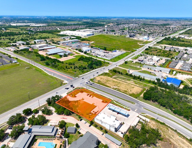
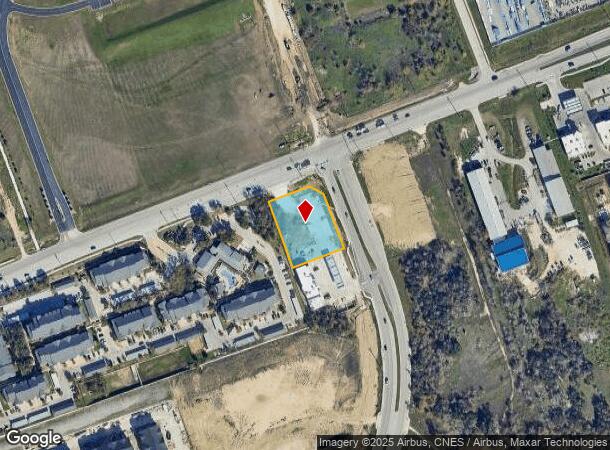
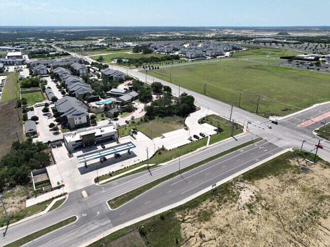
Property Record
610 Westinghouse Rd, Georgetown, TX 78626

This Property Is For Sale
Current Lease Availabilities
Property Detail
610 Westinghouse Rd
Austin
Horizontal Westinghouse Tract (Blk B Lts
Austin-Round Rock-San Marcos, TX
S12777 - HORIZONTAL WESTINGHOUSE TRACT (BLK B LTS 3 & 4), BLOCK B, LOT 4, ACRES 1.055
R623029
Williamson
Commercialacreage
Texas
2024
3,4
2025
1.06 AC
020822
Georgetown
NEARBY LISTINGS FOR SALE OR LEASE
DEMOGRAPHICS near 610 Westinghouse Rd
1 mile
3 mile
5 mile
2024 Total Population
9,713
54,746
177,390
2029 Population
14,090
79,247
256,656
Pop Growth 2024-2029
+ 45.06%
+ 44.75%
+ 44.68%
Average Age
37
36
37
2024 Total Households
3,968
21,063
63,856
HH Growth 2024-2029
+ 46.52%
+ 45.98%
+ 46.09%
Median Household Inc
$132,788
$99,511
$111,424
Avg Household Size
2.40
2.60
2.70
2024 Avg HH Vehicles
2.00
2.00
2.00
Median Home Value
$507,701
$455,993
$460,404
Median Year Built
2011
2010
2010
Nearby Places
Map Layers
Map Styles
 Street
 Aerial
Transit
 Traffic
 Biking
Places
Listings with unknown addresses are not visible on the map
- Restaurants
- Banks
- Shops
- Fitness
- Groceries
PUBLIC TRANSPORTATION
AIRPORT
Austin-Bergstrom International
Drive
Walk
Distance
Austin-Bergstrom International
47 min
34.1 mi
Killeen Municipal
Drive
Walk
Distance
Killeen Municipal
58 min
45.7 mi
Robert Gray AAF
Drive
Walk
Distance
Robert Gray AAF
61 min
47.5 mi
Nearby Properties
Address
Land Use
TOTAL SIZE
Lot Size
Zoning
Address
Land Use
TOTAL SIZE
Lot Size
Zoning
489,460 SF
55.81 AC
PF3
Address
Land Use
TOTAL SIZE
Lot Size
Zoning
543,047 SF
76.14 AC
PUD
Address
Land Use
TOTAL SIZE
Lot Size
Zoning
215,033 SF
101 AC
HEC
Address
Land Use
TOTAL SIZE
Lot Size
Zoning
374,545 SF
38.86 AC
Address
Land Use
TOTAL SIZE
Lot Size
Zoning
145,000 SF
147.12 AC
Address
Land Use
TOTAL SIZE
Lot Size
Zoning
334,021 SF
50.48 AC
3-OF
Address
Land Use
TOTAL SIZE
Lot Size
Zoning
354,066 SF
40.51 AC
Address
Land Use
TOTAL SIZE
Lot Size
Zoning
345,000 SF
48.61 AC
Address
Land Use
TOTAL SIZE
Lot Size
Zoning
467,100 SF
35.12 AC
Address
Land Use
TOTAL SIZE
Lot Size
Zoning
374,225 SF
11.58 AC
Address
Land Use
TOTAL SIZE
Lot Size
Zoning
411,020 SF
29.91 AC
PUD
Address
Land Use
TOTAL SIZE
Lot Size
Zoning
331,518 SF
21.88 AC
Address
Land Use
TOTAL SIZE
Lot Size
Zoning
301,452 SF
14.19 AC
Address
Land Use
TOTAL SIZE
Lot Size
Zoning
364,432 SF
20.56 AC
MF
Address
Land Use
TOTAL SIZE
Lot Size
Zoning
325,550 SF
15.42 AC
Address
Land Use
TOTAL SIZE
Lot Size
Zoning
379,701 SF
18.43 AC
Address
Land Use
TOTAL SIZE
Lot Size
Zoning
300,061 SF
19.19 AC
Address
Land Use
TOTAL SIZE
Lot Size
Zoning
295,680 SF
16 AC
MF
Address
Land Use
TOTAL SIZE
Lot Size
Zoning
299,400 SF
15.91 AC
MF
Address
Land Use
TOTAL SIZE
Lot Size
Zoning
450,880 SF
54.28 AC
Address
Land Use
TOTAL SIZE
Lot Size
Zoning
446,815 SF
30.55 AC
Address
Land Use
TOTAL SIZE
Lot Size
Zoning
294,145 SF
14.46 AC
Address
Land Use
TOTAL SIZE
Lot Size
Zoning
285,760 SF
15.71 AC
Address
Land Use
TOTAL SIZE
Lot Size
Zoning
217,013 SF
20.44 AC
Address
Land Use
TOTAL SIZE
Lot Size
Zoning
236,569 SF
26.86 AC
PUD
Address
Land Use
TOTAL SIZE
Lot Size
Zoning
395,492 SF
7.16 AC
Address
Land Use
TOTAL SIZE
Lot Size
Zoning
297,937 SF
14.44 AC
Address
Land Use
TOTAL SIZE
Lot Size
Zoning
326,218 SF
44.54 AC
Address
Land Use
TOTAL SIZE
Lot Size
Zoning
364,797 SF
13.50 AC
Address
Land Use
TOTAL SIZE
Lot Size
Zoning
236,046 SF
9.77 AC
The World's #1 Commercial Real Estate Marketplace
Connect with us
© 2026 CoStar Group
The information above has been obtained from sources believed reliable. While we do not doubt its accuracy we have not verified it and make no guarantee, warranty or representation about it. It is your responsibility to independently confirm its accuracy and completeness. Any projections, opinions, assumptions, or estimates used are for example only and do not represent the current or future performance of the property. The value of this transaction to you depends on tax and other factors which should be evaluated by your tax, financial, and legal advisors. You and your advisors should conduct a careful, independent investigation of the property to determine to your satisfaction the suitability of the property for your needs.