Property Record
6100 Bethuy Rd, Ira, MI 48023


Save to a Folder
{{folder.Name}}
{{folder.ListingIds.length}} Properties
{{folder.ListingIds.length}} Property
Create a New Folder
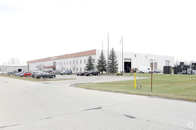
Property Detail
6100 Bethuy Rd
23-005-1001-200
BEG AT NW COR AS NOW MONUMENTED, SAID CORNER BEING 16.75' WESTERLY OF AND ALONG THE NORTHERLY SECTION LINE FROM A POINT DELINEATED AS THE NW COR, TH S 00D 21M 34S E 920.48' ALONG THE WLY LINE OF SECTION AS NOW MONUMENTED TO THE POB, TH E 685.99', TH
Manufacturinglight
Saint Clair
I-2
Michigan
B and X Area of moderate flood hazard, usually the area between the limits of the 100-year and 500-year floods.
6.52 AC
2025
St Clair & Lapeer Counties
2025
Detroit
650100
Detroit-Warren-Dearborn, MI
80,600 SF
NEARBY LISTINGS FOR SALE OR LEASE
DEMOGRAPHICS near 6100 Bethuy Rd
1 mile
3 mile
5 mile
2025 Total Population
137
15,276
42,390
2030 Population
136
15,505
43,174
Pop Growth 2025-2030
(0.73%)
+ 1.50%
+ 1.85%
Average Age
44
41
41
2025 Total Households
50
5,254
15,178
HH Growth 2025-2030
0.00%
+ 1.58%
+ 1.92%
Median Household Inc
$107,143
$94,051
$88,546
Avg Household Size
2.60
2.70
2.60
2025 Avg HH Vehicles
3.00
2.00
2.00
Median Home Value
$280,768
$299,172
$297,277
Median Year Built
1984
1994
1995
Nearby Places
Map Layers
Map Styles
 Street
 Aerial
Layers
 Traffic
 Biking
Places
Listings with unknown addresses are not visible on the map
- Restaurants
- Banks
- Shops
- Fitness
- Groceries
Nearby Properties
Address
Land Use
TOTAL SIZE
Lot Size
Zoning
Address
Land Use
TOTAL SIZE
Lot Size
Zoning
115,695 SF
Address
Land Use
TOTAL SIZE
Lot Size
Zoning
210,688 SF
20.13 AC
CG
Address
Land Use
TOTAL SIZE
Lot Size
Zoning
7,262 SF
127.87 AC
MH
Address
Land Use
TOTAL SIZE
Lot Size
Zoning
276,497 SF
31.19 AC
I-1
Address
Land Use
TOTAL SIZE
Lot Size
Zoning
89,620 SF
17.89 AC
Address
Land Use
TOTAL SIZE
Lot Size
Zoning
60,123 SF
120 AC
I-2
Address
Land Use
TOTAL SIZE
Lot Size
Zoning
176,142 SF
21.95 AC
IND
Address
Land Use
TOTAL SIZE
Lot Size
Zoning
49,600 SF
14.50 AC
I-2
Address
Land Use
TOTAL SIZE
Lot Size
Zoning
21,944 SF
131.37 AC
CG
Address
Land Use
TOTAL SIZE
Lot Size
Zoning
15,788 SF
4.28 AC
CG
Address
Land Use
TOTAL SIZE
Lot Size
Zoning
7.93 AC
I-1
Address
Land Use
TOTAL SIZE
Lot Size
Zoning
56,505 SF
I-1
Address
Land Use
TOTAL SIZE
Lot Size
Zoning
5,682 SF
47.12 AC
RT
Address
Land Use
TOTAL SIZE
Lot Size
Zoning
45 AC
RT
Address
Land Use
TOTAL SIZE
Lot Size
Zoning
88,925 SF
7.49 AC
GC
Address
Land Use
TOTAL SIZE
Lot Size
Zoning
3,436 SF
41 AC
RLD
Address
Land Use
TOTAL SIZE
Lot Size
Zoning
35,352 SF
3.26 AC
RM-2
Address
Land Use
TOTAL SIZE
Lot Size
Zoning
34,517 SF
4.59 AC
I
Address
Land Use
TOTAL SIZE
Lot Size
Zoning
67,040 SF
15 AC
I-1
Address
Land Use
TOTAL SIZE
Lot Size
Zoning
14,744 SF
1.94 AC
CG
Address
Land Use
TOTAL SIZE
Lot Size
Zoning
19,179 SF
116.03 AC
R-80
Address
Land Use
TOTAL SIZE
Lot Size
Zoning
40,344 SF
18.42 AC
C3 GEN
Address
Land Use
TOTAL SIZE
Lot Size
Zoning
33,320 SF
2.34 AC
I-2
Address
Land Use
TOTAL SIZE
Lot Size
Zoning
10,030 SF
3.88 AC
I-2
Address
Land Use
TOTAL SIZE
Lot Size
Zoning
15,200 SF
9.95 AC
M1 LIG
Address
Land Use
TOTAL SIZE
Lot Size
Zoning
1,500 SF
186.84 AC
AG
Address
Land Use
TOTAL SIZE
Lot Size
Zoning
3,321 SF
72.15 AC
AEC
Address
Land Use
TOTAL SIZE
Lot Size
Zoning
22,616 SF
3.07 AC
GC
Address
Land Use
TOTAL SIZE
Lot Size
Zoning
28,912 SF
5 AC
IND
The World's #1 Commercial Real Estate Marketplace
Connect with us
© 2026 CoStar Group
The information above has been obtained from sources believed reliable. While we do not doubt its accuracy we have not verified it and make no guarantee, warranty or representation about it. It is your responsibility to independently confirm its accuracy and completeness. Any projections, opinions, assumptions, or estimates used are for example only and do not represent the current or future performance of the property. The value of this transaction to you depends on tax and other factors which should be evaluated by your tax, financial, and legal advisors. You and your advisors should conduct a careful, independent investigation of the property to determine to your satisfaction the suitability of the property for your needs.