Property Record
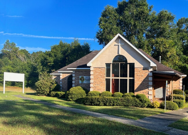
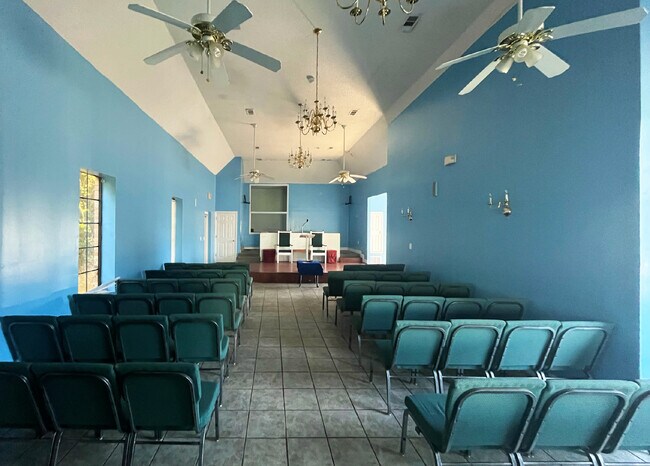
6100 Moffett Rd, Mobile, AL 36618

Property Detail
6100 Moffett Rd
23-08-33-2-000-018.001
BEG AT A PT ON TH NE SD OF TH STATE HWY NO 98 OR MOFFETT RD (80 FT ROW) A DIS OF 463 FT NWLY FROM WHERE TH N-S/L OF TH CNTR
Recreationalentertainmentgeneral
MOBILE
B and X Area of moderate flood hazard, usually the area between the limits of the 100-year and 500-year floods.
Alabama
0
0.18 AC
2025
West Mobile
003408
Mobile
2,090 SF
Mobile, AL
NEARBY LISTINGS FOR SALE OR LEASE
-
-
View all Mobile listings for sale on LoopNet.com
DEMOGRAPHICS near 6100 Moffett Rd
1 mile
3 mile
5 mile
2024 Total Population
843
25,506
73,110
2029 Population
834
25,122
72,484
Pop Growth 2024-2029
(1.07%)
(1.51%)
(0.86%)
Average Age
43
40
39
2024 Total Households
331
9,482
27,467
HH Growth 2024-2029
(0.91%)
(1.56%)
(0.97%)
Median Household Inc
$53,854
$57,010
$55,323
Avg Household Size
2.50
2.60
2.50
2024 Avg HH Vehicles
2.00
2.00
2.00
Median Home Value
$221,951
$160,229
$181,270
Median Year Built
1987
1978
1978
Nearby Places
Map Layers
Map Styles
 Street
 Aerial
Transit
 Traffic
 Biking
Places
Listings with unknown addresses are not visible on the map
- Restaurants
- Banks
- Shops
- Fitness
- Groceries
PUBLIC TRANSPORTATION
AIRPORT
Mobile Regional
Drive
Walk
Distance
Mobile Regional
19 min
8.7 mi
Mobile International
Drive
Walk
Distance
Mobile International
24 min
14.9 mi
Freight Ports
Port of Mobile
Drive
Walk
Distance
Port of Mobile
20 min
14.0 mi
SALE & LEASE HISTORY
LISTING DATE
SALE/LEASE

Oct 13, 2025
For Sale
Nearby Properties
Address
Land Use
TOTAL SIZE
Lot Size
Zoning
Address
Land Use
TOTAL SIZE
Lot Size
Zoning
15,960 SF
11.06 AC
Address
Land Use
TOTAL SIZE
Lot Size
Zoning
120,284 SF
15.36 AC
Address
Land Use
TOTAL SIZE
Lot Size
Zoning
93,199 SF
622 AC
Address
Land Use
TOTAL SIZE
Lot Size
Zoning
180,836 SF
28.59 AC
Address
Land Use
TOTAL SIZE
Lot Size
Zoning
12,800 SF
160.22 AC
Address
Land Use
TOTAL SIZE
Lot Size
Zoning
29,904 SF
6.70 AC
Address
Land Use
TOTAL SIZE
Lot Size
Zoning
63,771 SF
12.85 AC
Address
Land Use
TOTAL SIZE
Lot Size
Zoning
73,500 SF
Address
Land Use
TOTAL SIZE
Lot Size
Zoning
89,430 SF
70.53 AC
Address
Land Use
TOTAL SIZE
Lot Size
Zoning
3,200 SF
119 AC
Address
Land Use
TOTAL SIZE
Lot Size
Zoning
20,485 SF
148.31 AC
Address
Land Use
TOTAL SIZE
Lot Size
Zoning
9,296 SF
9.88 AC
Address
Land Use
TOTAL SIZE
Lot Size
Zoning
1,976 SF
77 AC
Address
Land Use
TOTAL SIZE
Lot Size
Zoning
2,052 SF
119.74 AC
Address
Land Use
TOTAL SIZE
Lot Size
Zoning
51,452 SF
9 AC
Address
Land Use
TOTAL SIZE
Lot Size
Zoning
141,514 SF
19 AC
Address
Land Use
TOTAL SIZE
Lot Size
Zoning
89,556 SF
18 AC
Address
Land Use
TOTAL SIZE
Lot Size
Zoning
35,110 SF
Address
Land Use
TOTAL SIZE
Lot Size
Zoning
58,828 SF
15.08 AC
Address
Land Use
TOTAL SIZE
Lot Size
Zoning
22,046 SF
4.62 AC
Address
Land Use
TOTAL SIZE
Lot Size
Zoning
55,653 SF
7.02 AC
Address
Land Use
TOTAL SIZE
Lot Size
Zoning
41,306 SF
5.26 AC
Address
Land Use
TOTAL SIZE
Lot Size
Zoning
37,632 SF
5.40 AC
Address
Land Use
TOTAL SIZE
Lot Size
Zoning
5,825 SF
41.85 AC
Address
Land Use
TOTAL SIZE
Lot Size
Zoning
45,468 SF
3.91 AC
Address
Land Use
TOTAL SIZE
Lot Size
Zoning
122.39 AC
Address
Land Use
TOTAL SIZE
Lot Size
Zoning
14,688 SF
6.50 AC
Address
Land Use
TOTAL SIZE
Lot Size
Zoning
35,926 SF
9.17 AC
Address
Land Use
TOTAL SIZE
Lot Size
Zoning
46,492 SF
17 AC
Address
Land Use
TOTAL SIZE
Lot Size
Zoning
73,637 SF
16 AC
The World's #1 Commercial Real Estate Marketplace
Connect with us
© 2026 CoStar Group
The information above has been obtained from sources believed reliable. While we do not doubt its accuracy we have not verified it and make no guarantee, warranty or representation about it. It is your responsibility to independently confirm its accuracy and completeness. Any projections, opinions, assumptions, or estimates used are for example only and do not represent the current or future performance of the property. The value of this transaction to you depends on tax and other factors which should be evaluated by your tax, financial, and legal advisors. You and your advisors should conduct a careful, independent investigation of the property to determine to your satisfaction the suitability of the property for your needs.