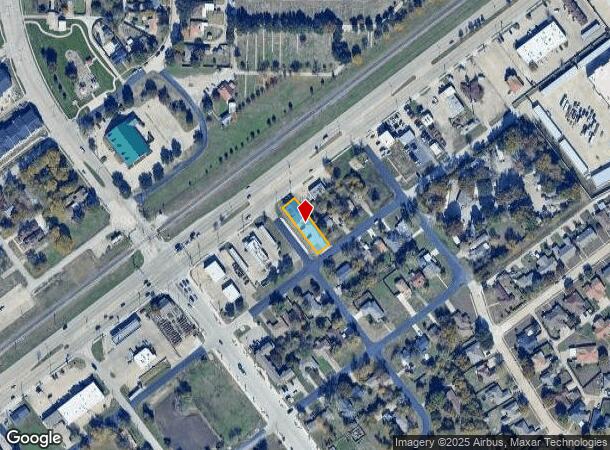
Property Record
6100 Highway 78, Sachse, TX 75048
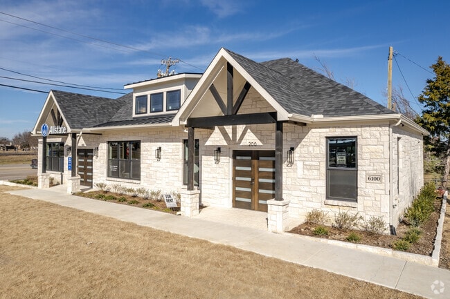
This Property Is For Sale
NEARBY LISTINGS FOR SALE OR LEASE
Property Detail
6100 Highway 78
Dallas/Ft Worth
Balleza
Dallas-Fort Worth-Arlington, TX
BALLEZA BLK A LT 1 ACS 0.218 INT202000174815 DD07022020 CO-DC 0005002400100 2CK00050024
480008100A0010000
Dallas
Officebuilding
Texas
2024
1
2025
0.22 AC
018154
Garland
2,362 SF
DEMOGRAPHICS near 6100 Highway 78
1 Mile
3 Mile
5 Mile
2024 Total Population
12,572
77,165
245,425
2029 Population
13,630
85,938
270,553
Pop Growth 2024-2029
+ 8.42%
+ 11.37%
+ 10.24%
Average Age
39
38
38
2024 Total Households
4,176
24,900
80,792
HH Growth 2024-2029
+ 8.43%
+ 10.90%
+ 9.89%
Median Household Inc
$112,652
$113,667
$96,151
Avg Household Size
3.00
3.10
3.00
2024 Avg HH Vehicles
2.00
2.00
2.00
Median Home Value
$309,289
$341,650
$301,204
Median Year Built
2002
2002
1999
Nearby Places
- Restaurants
- Banks
- Shops
- Fitness
- Groceries
PUBLIC TRANSPORTATION
AIRPORT
Dallas Love Field
DRIVE
WALK
Distance
Dallas Love Field
34 min
28.2 mi
Dallas-Fort Worth International
DRIVE
WALK
Distance
Dallas-Fort Worth International
37 min
36.4 mi
Freight Ports
Port of Shreveport
DRIVE
WALK
Distance
Port of Shreveport
1 min
177.8 mi
Nearby Properties
Address
Land Use
TOTAL SIZE
Lot Size
Zoning
Address
Land Use
TOTAL SIZE
Lot Size
Zoning
650,164 SF
66.57 AC
Z02
Address
Land Use
TOTAL SIZE
Lot Size
Zoning
350,553 SF
18.71 AC
MF-M
Address
Land Use
TOTAL SIZE
Lot Size
Zoning
328,843 SF
11.70 AC
Z239
Address
Land Use
TOTAL SIZE
Lot Size
Zoning
361,965 SF
11.12 AC
Z06
Address
Land Use
TOTAL SIZE
Lot Size
Zoning
231,434 SF
11.27 AC
Z06
Address
Land Use
TOTAL SIZE
Lot Size
Zoning
367,458 SF
13.42 AC
Address
Land Use
TOTAL SIZE
Lot Size
Zoning
310,382 SF
11.78 AC
Z148
Address
Land Use
TOTAL SIZE
Lot Size
Zoning
320,801 SF
10.14 AC
Z236
Address
Land Use
TOTAL SIZE
Lot Size
Zoning
250,602 SF
4.99 AC
Z01
Address
Land Use
TOTAL SIZE
Lot Size
Zoning
285,392 SF
19.44 AC
MF-M
Address
Land Use
TOTAL SIZE
Lot Size
Zoning
423,253 SF
30.26 AC
Z239
Address
Land Use
TOTAL SIZE
Lot Size
Zoning
441,356 SF
74.94 AC
Address
Land Use
TOTAL SIZE
Lot Size
Zoning
385,735 SF
13.13 AC
Address
Land Use
TOTAL SIZE
Lot Size
Zoning
266,957 SF
11.34 AC
MFR
Address
Land Use
TOTAL SIZE
Lot Size
Zoning
342,658 SF
4.94 AC
Z239
Address
Land Use
TOTAL SIZE
Lot Size
Zoning
366,600 SF
8.09 AC
Z06
Address
Land Use
TOTAL SIZE
Lot Size
Zoning
331,684 SF
9.80 AC
Z148
Address
Land Use
TOTAL SIZE
Lot Size
Zoning
403,206 SF
4 AC
Z239
Address
Land Use
TOTAL SIZE
Lot Size
Zoning
117,500 SF
16.71 AC
Z239
Address
Land Use
TOTAL SIZE
Lot Size
Zoning
65,595 SF
19.22 AC
Z239
Address
Land Use
TOTAL SIZE
Lot Size
Zoning
286,659 SF
9.94 AC
Z236
Address
Land Use
TOTAL SIZE
Lot Size
Zoning
259,280 SF
5.15 AC
Z01
Address
Land Use
TOTAL SIZE
Lot Size
Zoning
228,536 SF
10.54 AC
MF-M
Address
Land Use
TOTAL SIZE
Lot Size
Zoning
114,945 SF
19.71 AC
TC
Address
Land Use
TOTAL SIZE
Lot Size
Zoning
60,593 SF
35.93 AC
Z06
Address
Land Use
TOTAL SIZE
Lot Size
Zoning
473,201 SF
13.32 AC
Address
Land Use
TOTAL SIZE
Lot Size
Zoning
223,052 SF
5.81 AC
Z236
Address
Land Use
TOTAL SIZE
Lot Size
Zoning
173,273 SF
4 AC
Z02
Address
Land Use
TOTAL SIZE
Lot Size
Zoning
148.23 AC
Z02
Address
Land Use
TOTAL SIZE
Lot Size
Zoning
111,948 SF
9.92 AC
Z239
The World's #1 Commercial Real Estate Marketplace
Connect with us
© 2025 CoStar Group
The information above has been obtained from sources believed reliable. While we do not doubt its accuracy we have not verified it and make no guarantee, warranty or representation about it. It is your responsibility to independently confirm its accuracy and completeness. Any projections, opinions, assumptions, or estimates used are for example only and do not represent the current or future performance of the property. The value of this transaction to you depends on tax and other factors which should be evaluated by your tax, financial, and legal advisors. You and your advisors should conduct a careful, independent investigation of the property to determine to your satisfaction the suitability of the property for your needs.