Property Record
6102 Clay Ave Sw, Grand Rapids, MI 49548
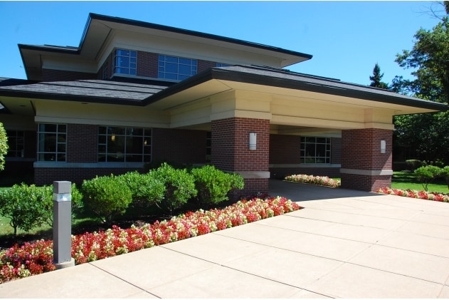
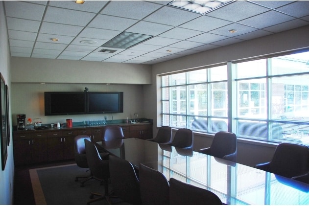
This Property Is For Sale
NEARBY LISTINGS FOR SALE OR LEASE
Property Detail
6102 Clay Ave Sw
41-21-01-600-003
THAT PART OF S 363 FT OF NFRL 1/2 NWFRL 1/4 LYING E OF A LINE WHICH IS 700 FT ELY OF /MEAS PERP TO/ SURVEY CL OF US131
Commercialnec
Kent
X
Michigan
26005C0125G
4.83 AC
2024
Byron/Gaines
2025
West Michigan
012901
Grand Rapids-Wyoming, MI
20,160 SF
DEMOGRAPHICS near 6102 Clay Ave Sw
1 Mile
3 Mile
5 Mile
2024 Total Population
7,759
74,629
178,541
2029 Population
7,783
75,340
180,336
Pop Growth 2024-2029
+ 0.31%
+ 0.95%
+ 1.01%
Average Age
35
38
38
2024 Total Households
2,791
28,040
67,418
HH Growth 2024-2029
+ 0.25%
+ 0.97%
+ 1.00%
Median Household Inc
$54,942
$66,594
$67,815
Avg Household Size
2.70
2.60
2.60
2024 Avg HH Vehicles
2.00
2.00
2.00
Median Home Value
$133,577
$222,956
$222,323
Median Year Built
1987
1983
1980
Nearby Places
Map Layers
Map Styles
 Street
 Aerial
- Restaurants
- Banks
- Shops
- Fitness
- Groceries
PUBLIC TRANSPORTATION
COMMUTER RAIL
Grand Rapids Vernon J. Ehlers Station (Pere Marquette - Amtrak)
DRIVE
WALK
Distance
Grand Rapids Vernon J. Ehlers Station (Pere Marquette - Amtrak)
13 min
8.0 mi
AIRPORT
Gerald R Ford International
DRIVE
WALK
Distance
Gerald R Ford International
22 min
9.3 mi
Freight Ports
Port Milwaukee
DRIVE
WALK
Distance
Port Milwaukee
307 min
260.9 mi
Nearby Properties
Address
Land Use
TOTAL SIZE
Lot Size
Zoning
Address
Land Use
TOTAL SIZE
Lot Size
Zoning
290,627 SF
Address
Land Use
TOTAL SIZE
Lot Size
Zoning
295,027 SF
51.42 AC
I3
Address
Land Use
TOTAL SIZE
Lot Size
Zoning
63,788 SF
124.62 AC
D1
Address
Land Use
TOTAL SIZE
Lot Size
Zoning
48.43 AC
PUD-PL UNI
Address
Land Use
TOTAL SIZE
Lot Size
Zoning
649,177 SF
55.67 AC
SD-IT
Address
Land Use
TOTAL SIZE
Lot Size
Zoning
487,739 SF
73.87 AC
RR
Address
Land Use
TOTAL SIZE
Lot Size
Zoning
26.94 AC
Address
Land Use
TOTAL SIZE
Lot Size
Zoning
Address
Land Use
TOTAL SIZE
Lot Size
Zoning
38.98 AC
PUD-PL UNI
Address
Land Use
TOTAL SIZE
Lot Size
Zoning
112,040 SF
9.69 AC
PUD3
Address
Land Use
TOTAL SIZE
Lot Size
Zoning
Address
Land Use
TOTAL SIZE
Lot Size
Zoning
386,450 SF
29.10 AC
Address
Land Use
TOTAL SIZE
Lot Size
Zoning
264,739 SF
26.56 AC
I2
Address
Land Use
TOTAL SIZE
Lot Size
Zoning
25.05 AC
R3-MED RES
Address
Land Use
TOTAL SIZE
Lot Size
Zoning
465,772 SF
61.95 AC
I1
Address
Land Use
TOTAL SIZE
Lot Size
Zoning
206,562 SF
15.12 AC
R1
Address
Land Use
TOTAL SIZE
Lot Size
Zoning
22.35 AC
Address
Land Use
TOTAL SIZE
Lot Size
Zoning
179,436 SF
24.94 AC
I2
Address
Land Use
TOTAL SIZE
Lot Size
Zoning
212,353 SF
16.52 AC
R4
Address
Land Use
TOTAL SIZE
Lot Size
Zoning
20.30 AC
Address
Land Use
TOTAL SIZE
Lot Size
Zoning
128,872 SF
7.32 AC
PUD3
Address
Land Use
TOTAL SIZE
Lot Size
Zoning
20.50 AC
RR
Address
Land Use
TOTAL SIZE
Lot Size
Zoning
2,593 SF
18 AC
PUD-PL UNI
Address
Land Use
TOTAL SIZE
Lot Size
Zoning
Address
Land Use
TOTAL SIZE
Lot Size
Zoning
Address
Land Use
TOTAL SIZE
Lot Size
Zoning
158,240 SF
13.56 AC
R4
Address
Land Use
TOTAL SIZE
Lot Size
Zoning
179,056 SF
17.75 AC
PUD1
Address
Land Use
TOTAL SIZE
Lot Size
Zoning
349,885 SF
8.92 AC
I1
Address
Land Use
TOTAL SIZE
Lot Size
Zoning
31,658 SF
2.47 AC
PUD3
Address
Land Use
TOTAL SIZE
Lot Size
Zoning
229,572 SF
16.20 AC
PUD-PL UNI
The World's #1 Commercial Real Estate Marketplace
Connect with us
© 2025 CoStar Group
The information above has been obtained from sources believed reliable. While we do not doubt its accuracy we have not verified it and make no guarantee, warranty or representation about it. It is your responsibility to independently confirm its accuracy and completeness. Any projections, opinions, assumptions, or estimates used are for example only and do not represent the current or future performance of the property. The value of this transaction to you depends on tax and other factors which should be evaluated by your tax, financial, and legal advisors. You and your advisors should conduct a careful, independent investigation of the property to determine to your satisfaction the suitability of the property for your needs.