Property Record
6003 Bay Island Dr, Garland, TX 75043
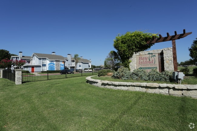
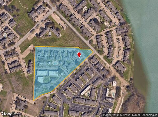
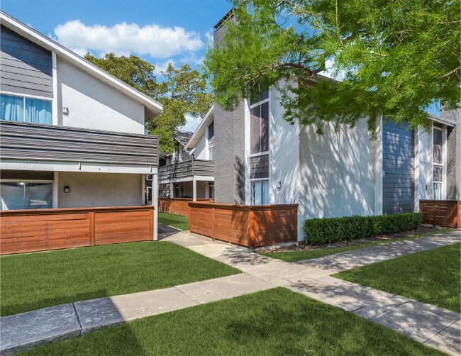

This Property Is For Sale
NEARBY LISTINGS FOR SALE OR LEASE
-
-
View all Garland listings for sale on LoopNet.com
Property Detail
6003 Bay Island Dr
Dallas-Fort Worth-Arlington, TX
Bay Island 2
26032500030010000
BAY ISLAND 2 BLK C PT LT 1 & PT ABST 791 ACS 6.789 INT202200226845 DD08172022 CO-DC 0325000300100 2CG03250003
Apartment
Dallas
X
Texas
48257C0025E
1
2024
6.79 AC
2025
Garland
018141
Dallas/Ft Worth
115,665 SF
DEMOGRAPHICS near 6003 Bay Island Dr
1 Mile
3 Mile
5 Mile
2024 Total Population
5,587
42,017
145,384
2029 Population
5,648
42,632
153,798
Pop Growth 2024-2029
+ 1.09%
+ 1.46%
+ 5.79%
Average Age
35
39
39
2024 Total Households
2,586
15,439
50,990
HH Growth 2024-2029
+ 0.73%
+ 1.33%
+ 6.20%
Median Household Inc
$42,903
$77,654
$85,837
Avg Household Size
2.10
2.70
2.80
2024 Avg HH Vehicles
2.00
2.00
2.00
Median Home Value
$139,627
$264,931
$272,281
Median Year Built
1982
1988
1987
Nearby Places
- Restaurants
- Banks
- Shops
- Fitness
- Groceries
PUBLIC TRANSPORTATION
AIRPORT
Dallas Love Field
DRIVE
WALK
Distance
Dallas Love Field
35 min
21.7 mi
Dallas-Fort Worth International
DRIVE
WALK
Distance
Dallas-Fort Worth International
47 min
38.5 mi
Freight Ports
Port of Shreveport
DRIVE
WALK
Distance
Port of Shreveport
209 min
191.3 mi
Nearby Properties
Address
Land Use
TOTAL SIZE
Lot Size
Zoning
Address
Land Use
TOTAL SIZE
Lot Size
Zoning
559,567 SF
10.85 AC
Z80
Address
Land Use
TOTAL SIZE
Lot Size
Zoning
441,557 SF
20.14 AC
Z239
Address
Land Use
TOTAL SIZE
Lot Size
Zoning
283,096 SF
10.18 AC
Z80
Address
Land Use
TOTAL SIZE
Lot Size
Zoning
260,782 SF
16.30 AC
Z77
Address
Land Use
TOTAL SIZE
Lot Size
Zoning
427,231 SF
9.96 AC
Z38
Address
Land Use
TOTAL SIZE
Lot Size
Zoning
336,685 SF
18.51 AC
Z85
Address
Land Use
TOTAL SIZE
Lot Size
Zoning
336,035 SF
21.78 AC
Z160
Address
Land Use
TOTAL SIZE
Lot Size
Zoning
710,600 SF
3.91 AC
Z80
Address
Land Use
TOTAL SIZE
Lot Size
Zoning
197,284 SF
10.70 AC
Z02
Address
Land Use
TOTAL SIZE
Lot Size
Zoning
178,125 SF
10.50 AC
Z77
Address
Land Use
TOTAL SIZE
Lot Size
Zoning
495,735 SF
2.92 AC
Z80
Address
Land Use
TOTAL SIZE
Lot Size
Zoning
138,183 SF
4.76 AC
Z80
Address
Land Use
TOTAL SIZE
Lot Size
Zoning
210,375 SF
7.54 AC
Address
Land Use
TOTAL SIZE
Lot Size
Zoning
43,600 SF
62.86 AC
Z306
Address
Land Use
TOTAL SIZE
Lot Size
Zoning
223,216 SF
13.79 AC
Z239
Address
Land Use
TOTAL SIZE
Lot Size
Zoning
43.27 AC
Z80
Address
Land Use
TOTAL SIZE
Lot Size
Zoning
92,413 SF
4.98 AC
Z85
Address
Land Use
TOTAL SIZE
Lot Size
Zoning
151,893 SF
5.40 AC
Z308
Address
Land Use
TOTAL SIZE
Lot Size
Zoning
159,595 SF
13.66 AC
Z239
Address
Land Use
TOTAL SIZE
Lot Size
Zoning
130,696 SF
16.17 AC
Z85
Address
Land Use
TOTAL SIZE
Lot Size
Zoning
100 SF
58.70 AC
Z02
Address
Land Use
TOTAL SIZE
Lot Size
Zoning
187 SF
8.80 AC
Z239
Address
Land Use
TOTAL SIZE
Lot Size
Zoning
178,197 SF
4.42 AC
Z239
Address
Land Use
TOTAL SIZE
Lot Size
Zoning
71,892 SF
5.35 AC
Z160
Address
Land Use
TOTAL SIZE
Lot Size
Zoning
82,000 SF
29.50 AC
Z386
Address
Land Use
TOTAL SIZE
Lot Size
Zoning
80,535 SF
2.35 AC
Z85
Address
Land Use
TOTAL SIZE
Lot Size
Zoning
22,771 SF
4.22 AC
Z309
Address
Land Use
TOTAL SIZE
Lot Size
Zoning
125,718 SF
8.48 AC
Z160
Address
Land Use
TOTAL SIZE
Lot Size
Zoning
72,520 SF
4.21 AC
Z239
The World's #1 Commercial Real Estate Marketplace
Connect with us
© 2025 CoStar Group
The information above has been obtained from sources believed reliable. While we do not doubt its accuracy we have not verified it and make no guarantee, warranty or representation about it. It is your responsibility to independently confirm its accuracy and completeness. Any projections, opinions, assumptions, or estimates used are for example only and do not represent the current or future performance of the property. The value of this transaction to you depends on tax and other factors which should be evaluated by your tax, financial, and legal advisors. You and your advisors should conduct a careful, independent investigation of the property to determine to your satisfaction the suitability of the property for your needs.