Property Record
611 Bell Fork Rd, Jacksonville, NC 28540
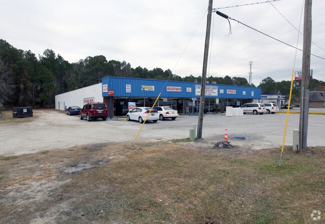

This Property Is For Sale
Property Detail
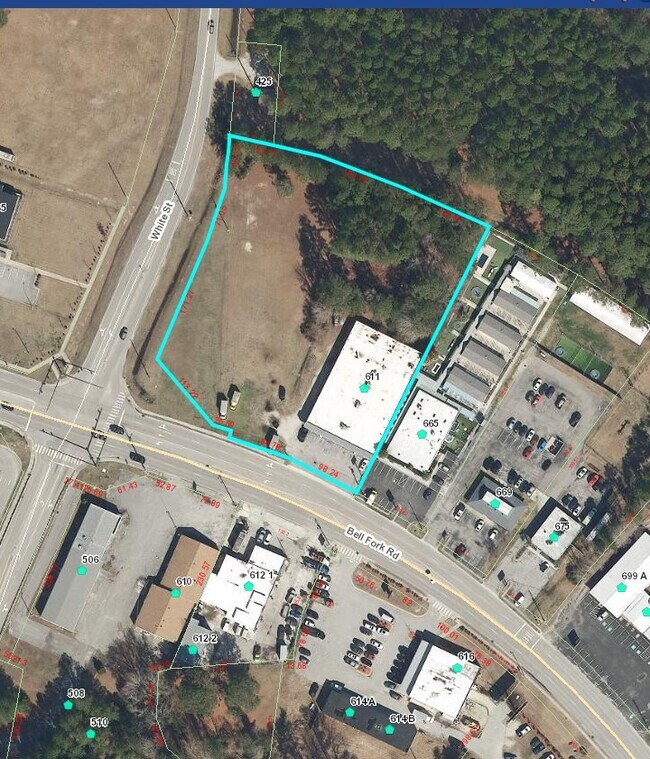
611 Bell Fork Rd
031222
BELL FORK RD
Storebuilding
Onslow
IND
North Carolina
B and X Area of moderate flood hazard, usually the area between the limits of the 100-year and 500-year floods.
2.75 AC
2025
North Carolina Southeast Area
2025
Other Market Areas
002600
Jacksonville, NC
15,000 SF
NEARBY LISTINGS FOR SALE OR LEASE
DEMOGRAPHICS near 611 Bell Fork Rd
1 mile
3 mile
5 mile
2025 Total Population
3,586
38,798
80,076
2030 Population
3,770
40,573
83,863
Pop Growth 2025-2030
+ 5.13%
+ 4.57%
+ 4.73%
Average Age
34
33
32
2025 Total Households
1,307
15,072
28,849
HH Growth 2025-2030
+ 5.66%
+ 4.88%
+ 5.08%
Median Household Inc
$51,917
$55,045
$59,671
Avg Household Size
2.50
2.40
2.50
2025 Avg HH Vehicles
2.00
2.00
2.00
Median Home Value
$167,558
$218,225
$234,258
Median Year Built
1983
1984
1992
Nearby Places
Map Layers
Map Styles
 Street
 Aerial
Layers
 Traffic
 Biking
Places
Listings with unknown addresses are not visible on the map
- Restaurants
- Banks
- Shops
- Fitness
- Groceries
PUBLIC TRANSPORTATION
AIRPORT
Albert J Ellis
Drive
Walk
Distance
Albert J Ellis
33 min
17.4 mi
Coastal Carolina Regional
Drive
Walk
Distance
Coastal Carolina Regional
59 min
42.7 mi
Nearby Properties
Address
Land Use
TOTAL SIZE
Lot Size
Zoning
Address
Land Use
TOTAL SIZE
Lot Size
Zoning
244,010 SF
52.70 AC
CC
Address
Land Use
TOTAL SIZE
Lot Size
Zoning
11,192 SF
64.76 AC
OI
Address
Land Use
TOTAL SIZE
Lot Size
Zoning
164,207 SF
43.55 AC
OI
Address
Land Use
TOTAL SIZE
Lot Size
Zoning
189,717 SF
1.93 AC
DTB
Address
Land Use
TOTAL SIZE
Lot Size
Zoning
185,000 SF
57.05 AC
OI
Address
Land Use
TOTAL SIZE
Lot Size
Zoning
87,143 SF
71.12 AC
OI
Address
Land Use
TOTAL SIZE
Lot Size
Zoning
25,860 SF
13.10 AC
RMF-HD
Address
Land Use
TOTAL SIZE
Lot Size
Zoning
10,560 SF
42.87 AC
RSF-7
Address
Land Use
TOTAL SIZE
Lot Size
Zoning
50,600 SF
17 AC
CC
Address
Land Use
TOTAL SIZE
Lot Size
Zoning
38,147 SF
3.14 AC
DTB
Address
Land Use
TOTAL SIZE
Lot Size
Zoning
94,547 SF
6.37 AC
DTB
Address
Land Use
TOTAL SIZE
Lot Size
Zoning
2,951 SF
16.39 AC
RMF-HD
Address
Land Use
TOTAL SIZE
Lot Size
Zoning
24,882 SF
7.30 AC
RMF-HD
Address
Land Use
TOTAL SIZE
Lot Size
Zoning
204,711 SF
9.70 AC
CC
Address
Land Use
TOTAL SIZE
Lot Size
Zoning
40,838 SF
48.30 AC
O-I
Address
Land Use
TOTAL SIZE
Lot Size
Zoning
16,248 SF
21.09 AC
RMF-HD
Address
Land Use
TOTAL SIZE
Lot Size
Zoning
94,263 SF
5.88 AC
DTB
Address
Land Use
TOTAL SIZE
Lot Size
Zoning
124,749 SF
16.31 AC
CC
Address
Land Use
TOTAL SIZE
Lot Size
Zoning
2,289 SF
7.22 AC
RMF-HD
Address
Land Use
TOTAL SIZE
Lot Size
Zoning
139,938 SF
13.87 AC
CC
Address
Land Use
TOTAL SIZE
Lot Size
Zoning
27,856 SF
20.11 AC
CC
Address
Land Use
TOTAL SIZE
Lot Size
Zoning
41,676 SF
16.53 AC
CC
Address
Land Use
TOTAL SIZE
Lot Size
Zoning
3,369 SF
79.40 AC
RMF-LD
Address
Land Use
TOTAL SIZE
Lot Size
Zoning
7,740 SF
16.50 AC
RMF-LD
Address
Land Use
TOTAL SIZE
Lot Size
Zoning
10,368 SF
23.17 AC
CC
Address
Land Use
TOTAL SIZE
Lot Size
Zoning
828 SF
8.56 AC
RMF-HD
Address
Land Use
TOTAL SIZE
Lot Size
Zoning
130,374 SF
15.72 AC
CC
Address
Land Use
TOTAL SIZE
Lot Size
Zoning
7,008 SF
9.72 AC
RMF-HD
Address
Land Use
TOTAL SIZE
Lot Size
Zoning
18,312 SF
16.25 AC
IND
Address
Land Use
TOTAL SIZE
Lot Size
Zoning
1,584 SF
61.32 AC
PDR
The World's #1 Commercial Real Estate Marketplace
Connect with us
© 2026 CoStar Group
The information above has been obtained from sources believed reliable. While we do not doubt its accuracy we have not verified it and make no guarantee, warranty or representation about it. It is your responsibility to independently confirm its accuracy and completeness. Any projections, opinions, assumptions, or estimates used are for example only and do not represent the current or future performance of the property. The value of this transaction to you depends on tax and other factors which should be evaluated by your tax, financial, and legal advisors. You and your advisors should conduct a careful, independent investigation of the property to determine to your satisfaction the suitability of the property for your needs.