Property Record
611 E 151St St, Phoenix, IL 60426
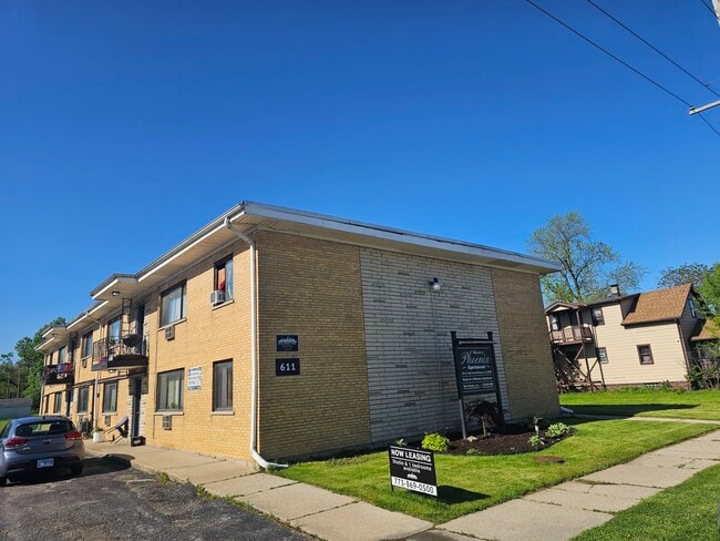
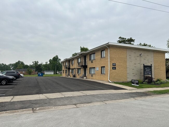
This Property Is For Sale
Property Detail
611 E 151St St
Chicago-Naperville-Elgin, IL-IN
(PHOENIX)(PARK) ADD TO (HARVEY) SUB OF LOT 5 OF RAVEN SLOOTS SUB OF LOTS 2-7 & LOT 15 IN SCHOOL TRUSTEES SUB OF SEC SEC 16-36
29-16-102-007-0000
Cook
Apartment
Illinois
B and X Area of moderate flood hazard, usually the area between the limits of the 100-year and 500-year floods.
2-7,1
2023
0.67 AC
2025
Southern Cook County
827200
Chicago
NEARBY LISTINGS FOR SALE OR LEASE
DEMOGRAPHICS near 611 E 151St St
1 mile
3 mile
5 mile
2024 Total Population
13,070
101,489
267,516
2029 Population
13,563
104,677
272,496
Pop Growth 2024-2029
+ 3.77%
+ 3.14%
+ 1.86%
Average Age
40
40
40
2024 Total Households
4,730
36,092
97,477
HH Growth 2024-2029
+ 3.53%
+ 3.01%
+ 1.61%
Median Household Inc
$51,747
$53,317
$57,725
Avg Household Size
2.70
2.70
2.60
2024 Avg HH Vehicles
1.00
2.00
2.00
Median Home Value
$118,316
$139,220
$161,913
Median Year Built
1959
1963
1962
Nearby Places
Map Layers
Map Styles
 Street
 Aerial
Transit
 Traffic
 Biking
Places
Listings with unknown addresses are not visible on the map
- Restaurants
- Banks
- Shops
- Fitness
- Groceries
PUBLIC TRANSPORTATION
TRANSIT/SUBWAY
Harvey Station (Metra Electric Line - Northeast Illinois Regional Commuter Railroad (Metra))
Drive
Walk
Distance
Harvey Station (Metra Electric Line - Northeast Illinois Regional Commuter Railroad (Metra))
3 min
17 min
0.9 mi
COMMUTER RAIL
Drive
Walk
Distance
3 min
17 min
0.8 mi
Harvey Station (Metra Electric Line - Northeast Illinois Regional Commuter Railroad (Metra))
Drive
Walk
Distance
Harvey Station (Metra Electric Line - Northeast Illinois Regional Commuter Railroad (Metra))
4 min
17 min
0.9 mi
AIRPORT
Chicago Midway International
Drive
Walk
Distance
Chicago Midway International
30 min
16.9 mi
Chicago O'Hare International
Drive
Walk
Distance
Chicago O'Hare International
55 min
38.6 mi
Nearby Properties
Address
Land Use
TOTAL SIZE
Lot Size
Zoning
Address
Land Use
TOTAL SIZE
Lot Size
Zoning
Address
Land Use
TOTAL SIZE
Lot Size
Zoning
Address
Land Use
TOTAL SIZE
Lot Size
Zoning
1.45 AC
Address
Land Use
TOTAL SIZE
Lot Size
Zoning
6.19 AC
Address
Land Use
TOTAL SIZE
Lot Size
Zoning
88,008 SF
3.96 AC
Address
Land Use
TOTAL SIZE
Lot Size
Zoning
4.85 AC
Address
Land Use
TOTAL SIZE
Lot Size
Zoning
44,184 SF
5 AC
Address
Land Use
TOTAL SIZE
Lot Size
Zoning
60,864 SF
5.55 AC
Address
Land Use
TOTAL SIZE
Lot Size
Zoning
40,489 SF
6.43 AC
Address
Land Use
TOTAL SIZE
Lot Size
Zoning
2.86 AC
Address
Land Use
TOTAL SIZE
Lot Size
Zoning
Address
Land Use
TOTAL SIZE
Lot Size
Zoning
Address
Land Use
TOTAL SIZE
Lot Size
Zoning
Address
Land Use
TOTAL SIZE
Lot Size
Zoning
67,314 SF
1.19 AC
Address
Land Use
TOTAL SIZE
Lot Size
Zoning
44,189 SF
3.09 AC
Address
Land Use
TOTAL SIZE
Lot Size
Zoning
49,229 SF
1.31 AC
Address
Land Use
TOTAL SIZE
Lot Size
Zoning
Address
Land Use
TOTAL SIZE
Lot Size
Zoning
216,386 SF
16.84 AC
PD 42
Address
Land Use
TOTAL SIZE
Lot Size
Zoning
38,111 SF
6.70 AC
Address
Land Use
TOTAL SIZE
Lot Size
Zoning
25,290 SF
1.05 AC
Address
Land Use
TOTAL SIZE
Lot Size
Zoning
233,490 SF
10.19 AC
Address
Land Use
TOTAL SIZE
Lot Size
Zoning
9,992 SF
1.40 AC
Address
Land Use
TOTAL SIZE
Lot Size
Zoning
6.34 AC
Address
Land Use
TOTAL SIZE
Lot Size
Zoning
Address
Land Use
TOTAL SIZE
Lot Size
Zoning
180,139 SF
18.78 AC
Address
Land Use
TOTAL SIZE
Lot Size
Zoning
225,800 SF
22.52 AC
M3-2,M1-2
Address
Land Use
TOTAL SIZE
Lot Size
Zoning
Address
Land Use
TOTAL SIZE
Lot Size
Zoning
Address
Land Use
TOTAL SIZE
Lot Size
Zoning
68,208 SF
1.28 AC
The World's #1 Commercial Real Estate Marketplace
Connect with us
© 2026 CoStar Group
The information above has been obtained from sources believed reliable. While we do not doubt its accuracy we have not verified it and make no guarantee, warranty or representation about it. It is your responsibility to independently confirm its accuracy and completeness. Any projections, opinions, assumptions, or estimates used are for example only and do not represent the current or future performance of the property. The value of this transaction to you depends on tax and other factors which should be evaluated by your tax, financial, and legal advisors. You and your advisors should conduct a careful, independent investigation of the property to determine to your satisfaction the suitability of the property for your needs.