Property Record
611 Eastgate Pkwy, Columbus, OH 43230
NEARBY LISTINGS FOR SALE OR LEASE
Property Detail
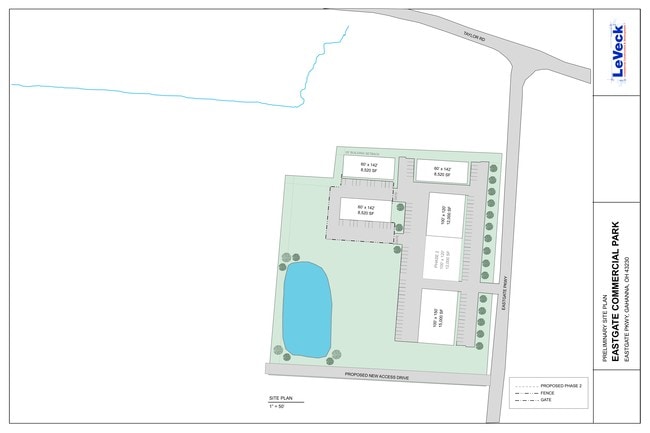
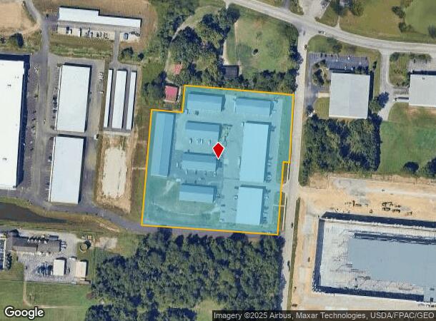
611 Eastgate Pkwy
027-000146
David Taylors Subdivision
Warehouse
TAYLOR ROAD R16 T1 1/4T3 7.624 ACRES
X
Franklin
39049C0213K
Ohio
2024
7.62 AC
2024
Airport
007303
Columbus
91,280 SF
Columbus, OH
DEMOGRAPHICS near 611 Eastgate Pkwy
1 Mile
3 Mile
5 Mile
2024 Total Population
4,488
65,888
180,969
2029 Population
4,500
65,820
181,639
Pop Growth 2024-2029
+ 0.27%
(0.10%)
+ 0.37%
Average Age
37
38
39
2024 Total Households
1,805
25,245
71,446
HH Growth 2024-2029
+ 0.28%
(0.12%)
+ 0.27%
Median Household Inc
$64,835
$79,950
$70,302
Avg Household Size
2.50
2.60
2.50
2024 Avg HH Vehicles
2.00
2.00
2.00
Median Home Value
$311,462
$257,338
$244,443
Median Year Built
1996
1994
1986
Nearby Places
Map Layers
Map Styles
 Street
 Aerial
- Restaurants
- Banks
- Shops
- Fitness
- Groceries
PUBLIC TRANSPORTATION
AIRPORT
John Glenn Columbus International
DRIVE
WALK
Distance
John Glenn Columbus International
15 min
6.1 mi
Freight Ports
Port of Baltimore
DRIVE
WALK
Distance
Port of Baltimore
453 min
395.2 mi
SALE & LEASE HISTORY
LISTING DATE
SALE/LEASE

Jun 19, 2019
For Lease
Nearby Properties
Address
Land Use
TOTAL SIZE
Lot Size
Zoning
Address
Land Use
TOTAL SIZE
Lot Size
Zoning
761,542 SF
21.30 AC
Address
Land Use
TOTAL SIZE
Lot Size
Zoning
208,472 SF
1.45 AC
Address
Land Use
TOTAL SIZE
Lot Size
Zoning
329,049 SF
38.53 AC
Address
Land Use
TOTAL SIZE
Lot Size
Zoning
1,003,816 SF
75.60 AC
Address
Land Use
TOTAL SIZE
Lot Size
Zoning
978,491 SF
72.31 AC
Address
Land Use
TOTAL SIZE
Lot Size
Zoning
164,095 SF
33.71 AC
Address
Land Use
TOTAL SIZE
Lot Size
Zoning
147,649 SF
5.15 AC
Address
Land Use
TOTAL SIZE
Lot Size
Zoning
122,526 SF
27 AC
Address
Land Use
TOTAL SIZE
Lot Size
Zoning
514,341 SF
46.79 AC
Address
Land Use
TOTAL SIZE
Lot Size
Zoning
705,707 SF
107.11 AC
Address
Land Use
TOTAL SIZE
Lot Size
Zoning
60,056 SF
25.98 AC
Address
Land Use
TOTAL SIZE
Lot Size
Zoning
137,136 SF
69.71 AC
Address
Land Use
TOTAL SIZE
Lot Size
Zoning
464,796 SF
7.33 AC
Address
Land Use
TOTAL SIZE
Lot Size
Zoning
166,628 SF
9.98 AC
Address
Land Use
TOTAL SIZE
Lot Size
Zoning
201,687 SF
20.97 AC
Address
Land Use
TOTAL SIZE
Lot Size
Zoning
43,829 SF
27.86 AC
Address
Land Use
TOTAL SIZE
Lot Size
Zoning
253,893 SF
12.57 AC
Address
Land Use
TOTAL SIZE
Lot Size
Zoning
171,366 SF
28.27 AC
Address
Land Use
TOTAL SIZE
Lot Size
Zoning
170,209 SF
15.03 AC
Address
Land Use
TOTAL SIZE
Lot Size
Zoning
51,968 SF
22.80 AC
Address
Land Use
TOTAL SIZE
Lot Size
Zoning
82,450 SF
28.27 AC
Address
Land Use
TOTAL SIZE
Lot Size
Zoning
264,250 SF
10.31 AC
Address
Land Use
TOTAL SIZE
Lot Size
Zoning
133,426 SF
8.64 AC
Address
Land Use
TOTAL SIZE
Lot Size
Zoning
511,125 SF
24.90 AC
Address
Land Use
TOTAL SIZE
Lot Size
Zoning
25,512 SF
18.89 AC
Address
Land Use
TOTAL SIZE
Lot Size
Zoning
176,140 SF
9.24 AC
Address
Land Use
TOTAL SIZE
Lot Size
Zoning
209,585 SF
24.94 AC
Address
Land Use
TOTAL SIZE
Lot Size
Zoning
88,963 SF
14 AC
Address
Land Use
TOTAL SIZE
Lot Size
Zoning
95,576 SF
16 AC
Address
Land Use
TOTAL SIZE
Lot Size
Zoning
29,720 SF
20.20 AC
The World's #1 Commercial Real Estate Marketplace
Connect with us
© 2026 CoStar Group
The information above has been obtained from sources believed reliable. While we do not doubt its accuracy we have not verified it and make no guarantee, warranty or representation about it. It is your responsibility to independently confirm its accuracy and completeness. Any projections, opinions, assumptions, or estimates used are for example only and do not represent the current or future performance of the property. The value of this transaction to you depends on tax and other factors which should be evaluated by your tax, financial, and legal advisors. You and your advisors should conduct a careful, independent investigation of the property to determine to your satisfaction the suitability of the property for your needs.