Property Record
611 Maple Ave, Hamilton, OH 45011
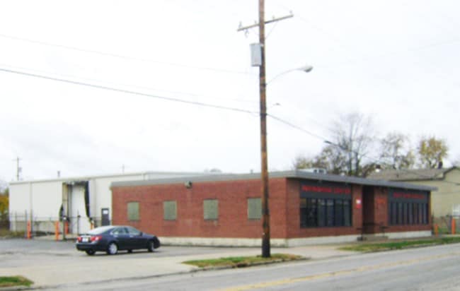
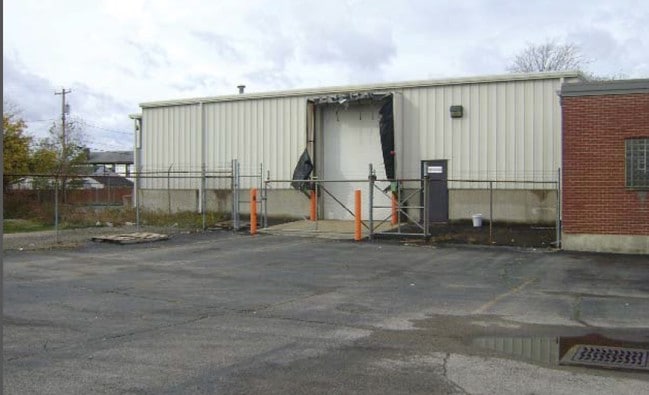
This Property Is For Sale
Current Lease Availabilities
Property Detail
611 Maple Ave
Cincinnati, OH-KY-IN
1973 ENT CONS W/ 073
P6441-019-000-071
Butler
Storebuilding
Ohio
B and X Area of moderate flood hazard, usually the area between the limits of the 100-year and 500-year floods.
1973
2024
0.45 AC
2025
Butler County
000400
Cincinnati/Dayton
8,054 SF
NEARBY LISTINGS FOR SALE OR LEASE
DEMOGRAPHICS near 611 Maple Ave
1 mile
3 mile
5 mile
2025 Total Population
16,182
73,674
129,484
2030 Population
16,827
75,846
132,917
Pop Growth 2025-2030
+ 3.99%
+ 2.95%
+ 2.65%
Average Age
36
39
40
2025 Total Households
5,762
28,602
49,651
HH Growth 2025-2030
+ 4.37%
+ 3.04%
+ 2.71%
Median Household Inc
$44,296
$59,116
$70,096
Avg Household Size
2.40
2.40
2.50
2025 Avg HH Vehicles
1.00
2.00
2.00
Median Home Value
$91,415
$178,854
$231,809
Median Year Built
1947
1956
1970
Nearby Places
Map Layers
Map Styles
 Street
 Aerial
Transit
 Traffic
 Biking
Places
Listings with unknown addresses are not visible on the map
- Restaurants
- Banks
- Shops
- Fitness
- Groceries
PUBLIC TRANSPORTATION
AIRPORT
Cincinnati/Northern Kentucky International
Drive
Walk
Distance
Cincinnati/Northern Kentucky International
65 min
45.1 mi
Nearby Properties
Address
Land Use
TOTAL SIZE
Lot Size
Zoning
Address
Land Use
TOTAL SIZE
Lot Size
Zoning
659,723 SF
27.80 AC
Address
Land Use
TOTAL SIZE
Lot Size
Zoning
336,010 SF
5.56 AC
ADV
Address
Land Use
TOTAL SIZE
Lot Size
Zoning
34,129 SF
13.88 AC
Address
Land Use
TOTAL SIZE
Lot Size
Zoning
14.65 AC
Address
Land Use
TOTAL SIZE
Lot Size
Zoning
14,559 SF
27.50 AC
Address
Land Use
TOTAL SIZE
Lot Size
Zoning
112,027 SF
0.78 AC
Address
Land Use
TOTAL SIZE
Lot Size
Zoning
28.47 AC
Address
Land Use
TOTAL SIZE
Lot Size
Zoning
30.51 AC
Address
Land Use
TOTAL SIZE
Lot Size
Zoning
2.75 AC
Address
Land Use
TOTAL SIZE
Lot Size
Zoning
34.58 AC
Address
Land Use
TOTAL SIZE
Lot Size
Zoning
0.37 AC
Address
Land Use
TOTAL SIZE
Lot Size
Zoning
215,969 SF
16.08 AC
ADV
Address
Land Use
TOTAL SIZE
Lot Size
Zoning
178,152 SF
63.48 AC
Address
Land Use
TOTAL SIZE
Lot Size
Zoning
124,549 SF
9.75 AC
Address
Land Use
TOTAL SIZE
Lot Size
Zoning
32,000 SF
10.24 AC
Address
Land Use
TOTAL SIZE
Lot Size
Zoning
220,612 SF
1.79 AC
Address
Land Use
TOTAL SIZE
Lot Size
Zoning
162,982 SF
16.96 AC
Address
Land Use
TOTAL SIZE
Lot Size
Zoning
259,203 SF
22.23 AC
Address
Land Use
TOTAL SIZE
Lot Size
Zoning
446,660 SF
30.51 AC
Address
Land Use
TOTAL SIZE
Lot Size
Zoning
310,200 SF
28.23 AC
Address
Land Use
TOTAL SIZE
Lot Size
Zoning
75,402 SF
0.45 AC
Address
Land Use
TOTAL SIZE
Lot Size
Zoning
166,169 SF
12.19 AC
Address
Land Use
TOTAL SIZE
Lot Size
Zoning
225,687 SF
22.43 AC
Address
Land Use
TOTAL SIZE
Lot Size
Zoning
111,418 SF
9.44 AC
Address
Land Use
TOTAL SIZE
Lot Size
Zoning
203,940 SF
11.01 AC
Address
Land Use
TOTAL SIZE
Lot Size
Zoning
Address
Land Use
TOTAL SIZE
Lot Size
Zoning
Address
Land Use
TOTAL SIZE
Lot Size
Zoning
111,174 SF
17.78 AC
Address
Land Use
TOTAL SIZE
Lot Size
Zoning
51,906 SF
0.81 AC
Address
Land Use
TOTAL SIZE
Lot Size
Zoning
408,194 SF
47.14 AC
The World's #1 Commercial Real Estate Marketplace
Connect with us
© 2026 CoStar Group
The information above has been obtained from sources believed reliable. While we do not doubt its accuracy we have not verified it and make no guarantee, warranty or representation about it. It is your responsibility to independently confirm its accuracy and completeness. Any projections, opinions, assumptions, or estimates used are for example only and do not represent the current or future performance of the property. The value of this transaction to you depends on tax and other factors which should be evaluated by your tax, financial, and legal advisors. You and your advisors should conduct a careful, independent investigation of the property to determine to your satisfaction the suitability of the property for your needs.