Property Record
611 W 2Nd St, Bonner Springs, KS 66012
NEARBY LISTINGS FOR SALE OR LEASE
Property Detail
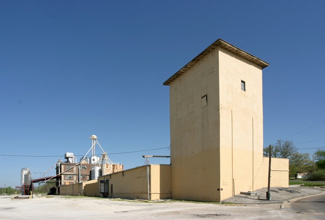
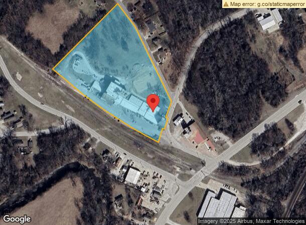
611 W 2Nd St
Kansas City, MO-KS
Tiblow Mills
203800
TIBLOW MILLS, S32, T11, R23, ACRES 6.89, LOT A, LOT B LS NELY 25.5FT & 12FT VAC ST ADJ; ALSO BEG SE COR LOT A; S20W-50.65FT, NWLY CUR RT-629.99FT, N47W-151.09FT, N48E-50.17FT, S47E-146.99FT, SELY CUR LT-610.39FT TO POB; ALSO BLUE GRASS RIDGE: L23 TO
Nightclub
Wyandotte
X
Kansas
20209C0117E
a
2025
9.79 AC
2025
Bonner Springs
044900
Kansas City
48,717 SF
DEMOGRAPHICS near 611 W 2Nd St
1 Mile
3 Mile
5 Mile
2024 Total Population
3,916
16,492
43,811
2029 Population
3,806
16,609
44,508
Pop Growth 2024-2029
(2.81%)
+ 0.71%
+ 1.59%
Average Age
38
38
38
2024 Total Households
1,545
5,835
15,345
HH Growth 2024-2029
(2.85%)
+ 0.45%
+ 1.45%
Median Household Inc
$64,737
$105,809
$109,434
Avg Household Size
2.50
2.80
2.80
2024 Avg HH Vehicles
2.00
2.00
2.00
Median Home Value
$177,855
$291,216
$314,525
Median Year Built
1962
1992
1998
Nearby Places
Map Layers
Map Styles
 Street
 Aerial
- Restaurants
- Banks
- Shops
- Fitness
- Groceries
PUBLIC TRANSPORTATION
AIRPORT
Kansas City International
DRIVE
WALK
Distance
Kansas City International
41 min
31.7 mi
Nearby Properties
Address
Land Use
TOTAL SIZE
Lot Size
Zoning
Address
Land Use
TOTAL SIZE
Lot Size
Zoning
276,310 SF
23.27 AC
PI
Address
Land Use
TOTAL SIZE
Lot Size
Zoning
50,750 SF
42.95 AC
I-1
Address
Land Use
TOTAL SIZE
Lot Size
Zoning
297,198 SF
60.55 AC
Address
Land Use
TOTAL SIZE
Lot Size
Zoning
66,916 SF
14.72 AC
AG
Address
Land Use
TOTAL SIZE
Lot Size
Zoning
80,190 SF
16.86 AC
R-1
Address
Land Use
TOTAL SIZE
Lot Size
Zoning
170,000 SF
12.71 AC
PI
Address
Land Use
TOTAL SIZE
Lot Size
Zoning
170,000 SF
12.71 AC
PI
Address
Land Use
TOTAL SIZE
Lot Size
Zoning
170,000 SF
14.87 AC
PI
Address
Land Use
TOTAL SIZE
Lot Size
Zoning
170,000 SF
12.72 AC
PI
Address
Land Use
TOTAL SIZE
Lot Size
Zoning
575,616 SF
35.52 AC
PI
Address
Land Use
TOTAL SIZE
Lot Size
Zoning
141,032 SF
68.59 AC
A1
Address
Land Use
TOTAL SIZE
Lot Size
Zoning
28,210 SF
317.17 AC
Address
Land Use
TOTAL SIZE
Lot Size
Zoning
161,076 SF
20.27 AC
CH
Address
Land Use
TOTAL SIZE
Lot Size
Zoning
22,136 SF
24.15 AC
Address
Land Use
TOTAL SIZE
Lot Size
Zoning
27,784 SF
2.53 AC
BC1
Address
Land Use
TOTAL SIZE
Lot Size
Zoning
6,380 SF
296.16 AC
BA1
Address
Land Use
TOTAL SIZE
Lot Size
Zoning
36,712 SF
8.70 AC
PUDMR
Address
Land Use
TOTAL SIZE
Lot Size
Zoning
9,157 SF
1.46 AC
PUDMR
Address
Land Use
TOTAL SIZE
Lot Size
Zoning
57,743 SF
6.18 AC
BR2
Address
Land Use
TOTAL SIZE
Lot Size
Zoning
19,113 SF
2.06 AC
BA2
Address
Land Use
TOTAL SIZE
Lot Size
Zoning
10,540 SF
15.05 AC
AG
Address
Land Use
TOTAL SIZE
Lot Size
Zoning
7,167 SF
1.01 AC
BR2
Address
Land Use
TOTAL SIZE
Lot Size
Zoning
167,873 SF
18.68 AC
BR2
Address
Land Use
TOTAL SIZE
Lot Size
Zoning
15,657 SF
1.46 AC
Address
Land Use
TOTAL SIZE
Lot Size
Zoning
154.64 AC
WC
Address
Land Use
TOTAL SIZE
Lot Size
Zoning
29,615 SF
1.98 AC
BR2
Address
Land Use
TOTAL SIZE
Lot Size
Zoning
20,354 SF
12.54 AC
BI1
Address
Land Use
TOTAL SIZE
Lot Size
Zoning
20,025 SF
5.32 AC
BA2
Address
Land Use
TOTAL SIZE
Lot Size
Zoning
27,277 SF
3.34 AC
PUDMR
Address
Land Use
TOTAL SIZE
Lot Size
Zoning
48,142 SF
490.85 AC
The World's #1 Commercial Real Estate Marketplace
Connect with us
© 2026 CoStar Group
The information above has been obtained from sources believed reliable. While we do not doubt its accuracy we have not verified it and make no guarantee, warranty or representation about it. It is your responsibility to independently confirm its accuracy and completeness. Any projections, opinions, assumptions, or estimates used are for example only and do not represent the current or future performance of the property. The value of this transaction to you depends on tax and other factors which should be evaluated by your tax, financial, and legal advisors. You and your advisors should conduct a careful, independent investigation of the property to determine to your satisfaction the suitability of the property for your needs.