Property Record
611 W Lamm Rd, Freeport, IL 61032

Save to a Folder
{{folder.Name}}
{{folder.ListingIds.length}} Properties
{{folder.ListingIds.length}} Property
Create a New Folder
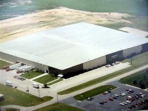
Property Detail
611 W Lamm Rd
Freeport, IL
PT NW1/4 SEC 18-26-8
18-19-18-100-014
Stephenson
Manufacturinglight
Illinois
B and X Area of moderate flood hazard, usually the area between the limits of the 100-year and 500-year floods.
11.48 AC
2025
Illinois North Area
2025
Other Market Areas
001200
NEARBY LISTINGS FOR SALE OR LEASE
DEMOGRAPHICS near 611 W Lamm Rd
1 mile
3 mile
5 mile
2025 Total Population
144
17,814
26,477
2030 Population
141
17,669
26,162
Pop Growth 2025-2030
(2.08%)
(0.81%)
(1.19%)
Average Age
50
42
43
2025 Total Households
57
7,633
11,531
HH Growth 2025-2030
(1.75%)
(1.01%)
(1.37%)
Median Household Inc
$55,714
$49,245
$51,313
Avg Household Size
2.20
2.20
2.20
2025 Avg HH Vehicles
2.00
1.00
1.00
Median Home Value
$130,769
$79,392
$97,963
Median Year Built
1962
1952
1958
Nearby Places
Map Layers
Map Styles
 Street
 Aerial
Layers
 Traffic
 Biking
Places
Listings with unknown addresses are not visible on the map
- Restaurants
- Banks
- Shops
- Fitness
- Groceries
PUBLIC TRANSPORTATION
AIRPORT
Chicago/Rockford International
Drive
Walk
Distance
Chicago/Rockford International
52 min
35.2 mi
Nearby Properties
Address
Land Use
TOTAL SIZE
Lot Size
Zoning
Address
Land Use
TOTAL SIZE
Lot Size
Zoning
499,200 SF
36.03 AC
Address
Land Use
TOTAL SIZE
Lot Size
Zoning
16.04 AC
Address
Land Use
TOTAL SIZE
Lot Size
Zoning
21.95 AC
Address
Land Use
TOTAL SIZE
Lot Size
Zoning
10.52 AC
Address
Land Use
TOTAL SIZE
Lot Size
Zoning
3.51 AC
Address
Land Use
TOTAL SIZE
Lot Size
Zoning
7.62 AC
Address
Land Use
TOTAL SIZE
Lot Size
Zoning
46.61 AC
Address
Land Use
TOTAL SIZE
Lot Size
Zoning
77,686 SF
4.37 AC
Address
Land Use
TOTAL SIZE
Lot Size
Zoning
26.60 AC
Address
Land Use
TOTAL SIZE
Lot Size
Zoning
2.85 AC
Address
Land Use
TOTAL SIZE
Lot Size
Zoning
1.44 AC
Address
Land Use
TOTAL SIZE
Lot Size
Zoning
15.25 AC
Address
Land Use
TOTAL SIZE
Lot Size
Zoning
10.37 AC
Address
Land Use
TOTAL SIZE
Lot Size
Zoning
13.20 AC
Address
Land Use
TOTAL SIZE
Lot Size
Zoning
Address
Land Use
TOTAL SIZE
Lot Size
Zoning
2.02 AC
Address
Land Use
TOTAL SIZE
Lot Size
Zoning
4.21 AC
Address
Land Use
TOTAL SIZE
Lot Size
Zoning
23,153 SF
6.41 AC
Address
Land Use
TOTAL SIZE
Lot Size
Zoning
5.14 AC
Address
Land Use
TOTAL SIZE
Lot Size
Zoning
Address
Land Use
TOTAL SIZE
Lot Size
Zoning
4.13 AC
Address
Land Use
TOTAL SIZE
Lot Size
Zoning
38.59 AC
Address
Land Use
TOTAL SIZE
Lot Size
Zoning
8,525 SF
3.02 AC
Address
Land Use
TOTAL SIZE
Lot Size
Zoning
9.32 AC
Address
Land Use
TOTAL SIZE
Lot Size
Zoning
7,754 SF
0.61 AC
Address
Land Use
TOTAL SIZE
Lot Size
Zoning
3.36 AC
Address
Land Use
TOTAL SIZE
Lot Size
Zoning
9,917 SF
5.50 AC
Address
Land Use
TOTAL SIZE
Lot Size
Zoning
18,145 SF
1.43 AC
Address
Land Use
TOTAL SIZE
Lot Size
Zoning
0.78 AC
The World's #1 Commercial Real Estate Marketplace
Connect with us
© 2026 CoStar Group
The information above has been obtained from sources believed reliable. While we do not doubt its accuracy we have not verified it and make no guarantee, warranty or representation about it. It is your responsibility to independently confirm its accuracy and completeness. Any projections, opinions, assumptions, or estimates used are for example only and do not represent the current or future performance of the property. The value of this transaction to you depends on tax and other factors which should be evaluated by your tax, financial, and legal advisors. You and your advisors should conduct a careful, independent investigation of the property to determine to your satisfaction the suitability of the property for your needs.