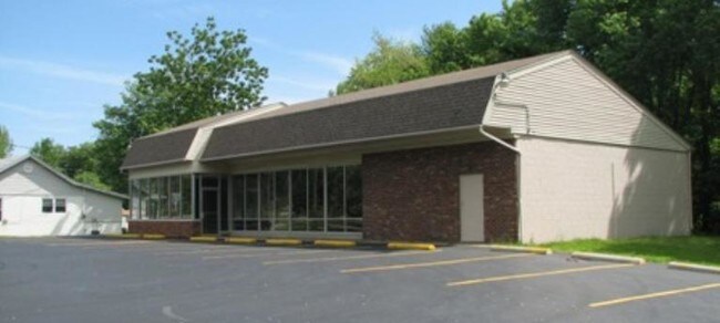
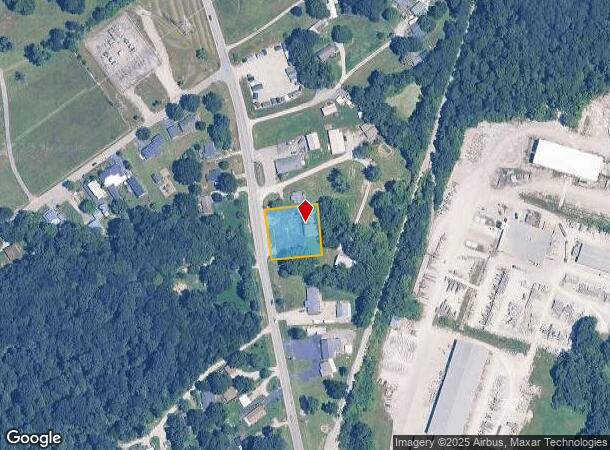
Property Record
6110 Grant Line Rd, New Albany, IN 47150
NEARBY LISTINGS FOR SALE OR LEASE
Property Detail
6110 Grant Line Rd
22-05-12-700-057.001-007
PRT S 1/2 127 ILL. GNT. 0.60 A.
Storebuilding
Floyd
X
Indiana
18019C0168E
0.60 AC
2024
Outlying Floyd County
2024
Louisville
070902
Louisville-Jefferson County, KY-IN
2,664 SF
DEMOGRAPHICS near 6110 Grant Line Rd
1 Mile
3 Mile
5 Mile
2024 Total Population
1,664
25,637
64,544
2029 Population
1,682
26,456
66,813
Pop Growth 2024-2029
+ 1.08%
+ 3.19%
+ 3.52%
Average Age
44
40
41
2024 Total Households
629
9,671
25,582
HH Growth 2024-2029
+ 1.11%
+ 3.17%
+ 3.55%
Median Household Inc
$102,155
$81,779
$66,203
Avg Household Size
2.50
2.60
2.40
2024 Avg HH Vehicles
2.00
2.00
2.00
Median Home Value
$267,768
$238,436
$199,013
Median Year Built
1995
1994
1986
Nearby Places
Map Layers
Map Styles
 Street
 Aerial
- Restaurants
- Banks
- Shops
- Fitness
- Groceries
PUBLIC TRANSPORTATION
AIRPORT
Louisville Muhammad Ali International
DRIVE
WALK
Distance
Louisville Muhammad Ali International
32 min
20.7 mi
Freight Ports
Port of Toledo
DRIVE
WALK
Distance
Port of Toledo
360 min
311.0 mi
SALE & LEASE HISTORY
LISTING DATE
SALE/LEASE

Mar 07, 2018
For Sale
Nearby Properties
Address
Land Use
TOTAL SIZE
Lot Size
Zoning
Address
Land Use
TOTAL SIZE
Lot Size
Zoning
27,360 SF
10.17 AC
Address
Land Use
TOTAL SIZE
Lot Size
Zoning
21,540 SF
9.35 AC
Address
Land Use
TOTAL SIZE
Lot Size
Zoning
84,873 SF
15.71 AC
Address
Land Use
TOTAL SIZE
Lot Size
Zoning
11,695 SF
18.33 AC
Address
Land Use
TOTAL SIZE
Lot Size
Zoning
270,377 SF
17.54 AC
Address
Land Use
TOTAL SIZE
Lot Size
Zoning
204,750 SF
26.96 AC
Address
Land Use
TOTAL SIZE
Lot Size
Zoning
58,884 SF
7.92 AC
Address
Land Use
TOTAL SIZE
Lot Size
Zoning
81,000 SF
44.74 AC
Address
Land Use
TOTAL SIZE
Lot Size
Zoning
2,300 SF
15.14 AC
Address
Land Use
TOTAL SIZE
Lot Size
Zoning
27,039 SF
3.35 AC
Address
Land Use
TOTAL SIZE
Lot Size
Zoning
80,812 SF
10.05 AC
Address
Land Use
TOTAL SIZE
Lot Size
Zoning
3,760 SF
3.05 AC
Address
Land Use
TOTAL SIZE
Lot Size
Zoning
44,144 SF
6.26 AC
Address
Land Use
TOTAL SIZE
Lot Size
Zoning
17,572 SF
9.25 AC
Address
Land Use
TOTAL SIZE
Lot Size
Zoning
27,132 SF
4.27 AC
Address
Land Use
TOTAL SIZE
Lot Size
Zoning
56,496 SF
7.28 AC
Address
Land Use
TOTAL SIZE
Lot Size
Zoning
21.12 AC
Address
Land Use
TOTAL SIZE
Lot Size
Zoning
19,426 SF
3.97 AC
Address
Land Use
TOTAL SIZE
Lot Size
Zoning
13,712 SF
2 AC
Address
Land Use
TOTAL SIZE
Lot Size
Zoning
200,208 SF
10.66 AC
Address
Land Use
TOTAL SIZE
Lot Size
Zoning
101,806 SF
8.60 AC
Address
Land Use
TOTAL SIZE
Lot Size
Zoning
23,508 SF
1.99 AC
Address
Land Use
TOTAL SIZE
Lot Size
Zoning
23,508 SF
2.05 AC
Address
Land Use
TOTAL SIZE
Lot Size
Zoning
175,036 SF
11.49 AC
Address
Land Use
TOTAL SIZE
Lot Size
Zoning
27,738 SF
6.50 AC
Address
Land Use
TOTAL SIZE
Lot Size
Zoning
88,507 SF
9.97 AC
Address
Land Use
TOTAL SIZE
Lot Size
Zoning
2,352 SF
3.09 AC
Address
Land Use
TOTAL SIZE
Lot Size
Zoning
42,916 SF
28.21 AC
Address
Land Use
TOTAL SIZE
Lot Size
Zoning
48,208 SF
3 AC
Address
Land Use
TOTAL SIZE
Lot Size
Zoning
15,000 SF
5 AC
The World's #1 Commercial Real Estate Marketplace
Connect with us
© 2025 CoStar Group
The information above has been obtained from sources believed reliable. While we do not doubt its accuracy we have not verified it and make no guarantee, warranty or representation about it. It is your responsibility to independently confirm its accuracy and completeness. Any projections, opinions, assumptions, or estimates used are for example only and do not represent the current or future performance of the property. The value of this transaction to you depends on tax and other factors which should be evaluated by your tax, financial, and legal advisors. You and your advisors should conduct a careful, independent investigation of the property to determine to your satisfaction the suitability of the property for your needs.