Property Record
6111 E Dougherty Rd, Acampo, CA 95220


Property Detail
6111 E Dougherty Rd
017-140-56
88-CONVEY 0.08 AC FOR RD WIDENING 88011664
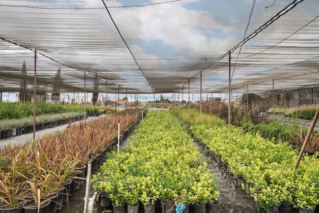
Horticulturegrowinghousesagricultural
San Joaquin
AG40
California
B and X Area of moderate flood hazard, usually the area between the limits of the 100-year and 500-year floods.
21.72 AC
2025
Lodi
2025
Stockton/Modesto
004600
Stockton-Lodi, CA
99,080 SF
NEARBY LISTINGS FOR SALE OR LEASE
DEMOGRAPHICS near 6111 E Dougherty Rd
1 mile
3 mile
5 mile
2024 Total Population
282
19,082
76,863
2029 Population
280
19,814
80,496
Pop Growth 2024-2029
(0.71%)
+ 3.84%
+ 4.73%
Average Age
41
38
39
2024 Total Households
103
6,674
27,710
HH Growth 2024-2029
(0.97%)
+ 3.94%
+ 4.80%
Median Household Inc
$103,000
$64,485
$79,194
Avg Household Size
2.70
2.80
2.70
2024 Avg HH Vehicles
3.00
2.00
2.00
Median Home Value
$1,016,216
$459,142
$465,447
Median Year Built
1974
1965
1976
Nearby Places
Map Layers
Map Styles
 Street
 Aerial
Transit
 Traffic
 Biking
Places
Listings with unknown addresses are not visible on the map
- Restaurants
- Banks
- Shops
- Fitness
- Groceries
PUBLIC TRANSPORTATION
COMMUTER RAIL
Lodi Amtrak Station (San Joaquins - Amtrak)
Drive
Walk
Distance
Lodi Amtrak Station (San Joaquins - Amtrak)
9 min
4.0 mi
AIRPORT
Stockton Metro
Drive
Walk
Distance
Stockton Metro
31 min
22.4 mi
Freight Ports
Port of Stockton
Drive
Walk
Distance
Port of Stockton
30 min
20.9 mi
SALE & LEASE HISTORY
LISTING DATE
SALE/LEASE

Oct 05, 2023
For Sale
Nearby Properties
Address
Land Use
TOTAL SIZE
Lot Size
Zoning
Address
Land Use
TOTAL SIZE
Lot Size
Zoning
4,800 SF
101.66 AC
AG40
Address
Land Use
TOTAL SIZE
Lot Size
Zoning
172,680 SF
7 AC
M
Address
Land Use
TOTAL SIZE
Lot Size
Zoning
580,500 SF
43.38 AC
Address
Land Use
TOTAL SIZE
Lot Size
Zoning
1,044,011 SF
20.24 AC
Address
Land Use
TOTAL SIZE
Lot Size
Zoning
10,100 SF
9.98 AC
IL
Address
Land Use
TOTAL SIZE
Lot Size
Zoning
473,000 SF
17.85 AC
Address
Land Use
TOTAL SIZE
Lot Size
Zoning
400,000 SF
17.81 AC
Address
Land Use
TOTAL SIZE
Lot Size
Zoning
334,515 SF
27.13 AC
Address
Land Use
TOTAL SIZE
Lot Size
Zoning
5,000 SF
6.69 AC
Address
Land Use
TOTAL SIZE
Lot Size
Zoning
12,167 SF
16.71 AC
IL
Address
Land Use
TOTAL SIZE
Lot Size
Zoning
55,632 SF
4.69 AC
Address
Land Use
TOTAL SIZE
Lot Size
Zoning
22,239 SF
1.32 AC
M
Address
Land Use
TOTAL SIZE
Lot Size
Zoning
21.73 AC
Address
Land Use
TOTAL SIZE
Lot Size
Zoning
261,100 SF
9.54 AC
Address
Land Use
TOTAL SIZE
Lot Size
Zoning
76,532 SF
3 AC
Address
Land Use
TOTAL SIZE
Lot Size
Zoning
41,946 SF
3.73 AC
Address
Land Use
TOTAL SIZE
Lot Size
Zoning
21.24 AC
Address
Land Use
TOTAL SIZE
Lot Size
Zoning
78.99 AC
AG40
Address
Land Use
TOTAL SIZE
Lot Size
Zoning
138,000 SF
19.03 AC
Address
Land Use
TOTAL SIZE
Lot Size
Zoning
13.89 AC
Address
Land Use
TOTAL SIZE
Lot Size
Zoning
48,000 SF
5.84 AC
AG20
Address
Land Use
TOTAL SIZE
Lot Size
Zoning
3,000 SF
11.20 AC
IT
Address
Land Use
TOTAL SIZE
Lot Size
Zoning
127,104 SF
18.11 AC
Address
Land Use
TOTAL SIZE
Lot Size
Zoning
1.21 AC
Address
Land Use
TOTAL SIZE
Lot Size
Zoning
23,227 SF
1.89 AC
O
Address
Land Use
TOTAL SIZE
Lot Size
Zoning
27,412 SF
32.63 AC
AG20
Address
Land Use
TOTAL SIZE
Lot Size
Zoning
52,020 SF
5.45 AC
Address
Land Use
TOTAL SIZE
Lot Size
Zoning
45,817 SF
2.95 AC
Address
Land Use
TOTAL SIZE
Lot Size
Zoning
50,112 SF
4.12 AC
Address
Land Use
TOTAL SIZE
Lot Size
Zoning
4.15 AC
The World's #1 Commercial Real Estate Marketplace
Connect with us
© 2026 CoStar Group
The information above has been obtained from sources believed reliable. While we do not doubt its accuracy we have not verified it and make no guarantee, warranty or representation about it. It is your responsibility to independently confirm its accuracy and completeness. Any projections, opinions, assumptions, or estimates used are for example only and do not represent the current or future performance of the property. The value of this transaction to you depends on tax and other factors which should be evaluated by your tax, financial, and legal advisors. You and your advisors should conduct a careful, independent investigation of the property to determine to your satisfaction the suitability of the property for your needs.