Property Record
6125 Iron Bridge Rd, North Chesterfield, VA 23234

This Property Is For Sale
NEARBY LISTINGS FOR SALE OR LEASE
Property Detail
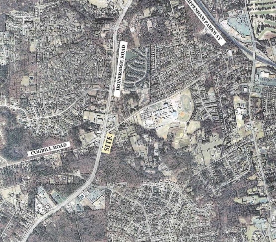
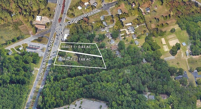
6125 Iron Bridge Rd
776-68-21-85-300-000
Courthouse Rd
Apartment
COURTHOUSE RD
X
Chesterfield
5101290100E
Virginia
2025
0.84 AC
2025
Iron Bridge Corridor
100805
Richmond VA
1,344 SF
Richmond, VA
DEMOGRAPHICS near 6125 Iron Bridge Rd
1 Mile
3 Mile
5 Mile
2024 Total Population
8,262
68,499
140,047
2029 Population
9,078
74,558
150,725
Pop Growth 2024-2029
+ 9.88%
+ 8.85%
+ 7.62%
Average Age
39
38
39
2024 Total Households
2,999
24,568
51,306
HH Growth 2024-2029
+ 10.00%
+ 8.96%
+ 7.69%
Median Household Inc
$72,631
$61,595
$59,735
Avg Household Size
2.70
2.70
2.60
2024 Avg HH Vehicles
2.00
2.00
2.00
Median Home Value
$246,086
$235,644
$236,429
Median Year Built
1986
1982
1980
Nearby Places
Map Layers
Map Styles
 Street
 Aerial
- Restaurants
- Banks
- Shops
- Fitness
- Groceries
PUBLIC TRANSPORTATION
COMMUTER RAIL
Richmond Main Street Amtrak Station (Northeast Regional - Amtrak)
DRIVE
WALK
Distance
Richmond Main Street Amtrak Station (Northeast Regional - Amtrak)
17 min
8.6 mi
AIRPORT
Richmond International
DRIVE
WALK
Distance
Richmond International
24 min
15.8 mi
Freight Ports
Virginia Port Authority - Richmond
DRIVE
WALK
Distance
Virginia Port Authority - Richmond
15 min
8.2 mi
Nearby Properties
Address
Land Use
TOTAL SIZE
Lot Size
Zoning
Address
Land Use
TOTAL SIZE
Lot Size
Zoning
73,867 SF
54.52 AC
R7 - SINGL
Address
Land Use
TOTAL SIZE
Lot Size
Zoning
231,168 SF
57.31 AC
R7 - SINGL
Address
Land Use
TOTAL SIZE
Lot Size
Zoning
387,548 SF
16.18 AC
C3 - COMMU
Address
Land Use
TOTAL SIZE
Lot Size
Zoning
117,516 SF
21.23 AC
R7 - SINGL
Address
Land Use
TOTAL SIZE
Lot Size
Zoning
12.42 AC
RTH - RES,
Address
Land Use
TOTAL SIZE
Lot Size
Zoning
613,315 SF
12.94 AC
I1 - LT IN
Address
Land Use
TOTAL SIZE
Lot Size
Zoning
83,186 SF
25.90 AC
O2 - CORP
Address
Land Use
TOTAL SIZE
Lot Size
Zoning
16,052 SF
552.02 AC
I1 - LT IN
Address
Land Use
TOTAL SIZE
Lot Size
Zoning
290,200 SF
50.99 AC
R7 - SINGL
Address
Land Use
TOTAL SIZE
Lot Size
Zoning
100 SF
22.70 AC
R7 - SINGL
Address
Land Use
TOTAL SIZE
Lot Size
Zoning
99,934 SF
27.15 AC
A - AGRICU
Address
Land Use
TOTAL SIZE
Lot Size
Zoning
100 SF
12.96 AC
R7 - SINGL
Address
Land Use
TOTAL SIZE
Lot Size
Zoning
117,740 SF
9.95 AC
R-48 MULTI
Address
Land Use
TOTAL SIZE
Lot Size
Zoning
100 SF
15.43 AC
RMF - RES,
Address
Land Use
TOTAL SIZE
Lot Size
Zoning
103,863 SF
20.55 AC
R7 - SINGL
Address
Land Use
TOTAL SIZE
Lot Size
Zoning
138,860 SF
23.68 AC
RMF - RES,
Address
Land Use
TOTAL SIZE
Lot Size
Zoning
132,570 SF
12.60 AC
R-48 MULTI
Address
Land Use
TOTAL SIZE
Lot Size
Zoning
100 SF
10.85 AC
R7 - SINGL
Address
Land Use
TOTAL SIZE
Lot Size
Zoning
6.90 AC
R7 - SINGL
Address
Land Use
TOTAL SIZE
Lot Size
Zoning
100 SF
8.02 AC
R7 - SINGL
Address
Land Use
TOTAL SIZE
Lot Size
Zoning
47,011 SF
8.23 AC
O2 - CORP
Address
Land Use
TOTAL SIZE
Lot Size
Zoning
56,148 SF
6.97 AC
R7 - SINGL
Address
Land Use
TOTAL SIZE
Lot Size
Zoning
100 SF
18.40 AC
RMF - RES,
Address
Land Use
TOTAL SIZE
Lot Size
Zoning
100 SF
12.93 AC
RMF - RES,
Address
Land Use
TOTAL SIZE
Lot Size
Zoning
5,412 SF
18.62 AC
C3 - COMMU
Address
Land Use
TOTAL SIZE
Lot Size
Zoning
100 SF
17.10 AC
RMF - RES,
Address
Land Use
TOTAL SIZE
Lot Size
Zoning
92,000 SF
5.41 AC
C5 - GEN B
Address
Land Use
TOTAL SIZE
Lot Size
Zoning
34,312 SF
7.74 AC
O2 - CORP
Address
Land Use
TOTAL SIZE
Lot Size
Zoning
100 SF
7.70 AC
R7 - SINGL
Address
Land Use
TOTAL SIZE
Lot Size
Zoning
132,570 SF
12.60 AC
R-48 MULTI
The World's #1 Commercial Real Estate Marketplace
Connect with us
© 2026 CoStar Group
The information above has been obtained from sources believed reliable. While we do not doubt its accuracy we have not verified it and make no guarantee, warranty or representation about it. It is your responsibility to independently confirm its accuracy and completeness. Any projections, opinions, assumptions, or estimates used are for example only and do not represent the current or future performance of the property. The value of this transaction to you depends on tax and other factors which should be evaluated by your tax, financial, and legal advisors. You and your advisors should conduct a careful, independent investigation of the property to determine to your satisfaction the suitability of the property for your needs.