Property Record
6111 W 7000 S, West Jordan, UT 84081

This Property Is For Sale
NEARBY LISTINGS FOR SALE OR LEASE
Property Detail
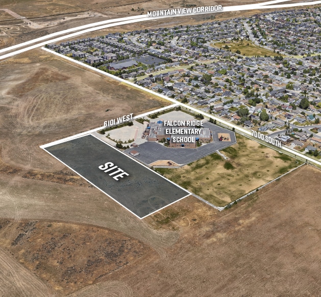
6111 W 7000 S
Salt Lake City, UT
Kearns
20-26-100-005-4002
PRIVILEGE TAX ON YIELD ON THE FOLLOWING DESC: BEG S 47 FT FRN 1/4 COR SEC 26, T2S, R2W, SLM; W 892.90 FT; S 886.40 FT; E892.90 FT; N 886.40 FT TO BEG. LESS THAT PORTION INSIDE KEARNS IMP DIST. 6.69 AC M OR L.
Federalproperty
Salt Lake
X
Utah
49035C0410G
6.69 AC
0
Central Valley West
2025
Salt Lake City
113542
DEMOGRAPHICS near 6111 W 7000 S
1 Mile
3 Mile
5 Mile
2024 Total Population
12,590
98,160
237,369
2029 Population
12,841
99,980
240,943
Pop Growth 2024-2029
+ 1.99%
+ 1.85%
+ 1.51%
Average Age
31
33
35
2024 Total Households
3,272
27,068
67,558
HH Growth 2024-2029
+ 1.93%
+ 1.79%
+ 1.44%
Median Household Inc
$98,999
$91,016
$90,672
Avg Household Size
3.80
3.50
3.40
2024 Avg HH Vehicles
3.00
2.00
2.00
Median Home Value
$388,181
$386,360
$387,041
Median Year Built
2004
1999
1990
Nearby Places
- Restaurants
- Banks
- Shops
- Fitness
- Groceries
PUBLIC TRANSPORTATION
AIRPORT
Salt Lake City International
DRIVE
WALK
Distance
Salt Lake City International
23 min
14.0 mi
Freight Ports
Port of Stockton
DRIVE
WALK
Distance
Port of Stockton
716 min
693.7 mi
Nearby Properties
Address
Land Use
TOTAL SIZE
Lot Size
Zoning
Address
Land Use
TOTAL SIZE
Lot Size
Zoning
338,177 SF
21.91 AC
M-1
Address
Land Use
TOTAL SIZE
Lot Size
Zoning
233,853 SF
6.05 AC
HFR
Address
Land Use
TOTAL SIZE
Lot Size
Zoning
308,722 SF
21.29 AC
M-1
Address
Land Use
TOTAL SIZE
Lot Size
Zoning
1,113,459 SF
80.09 AC
M
Address
Land Use
TOTAL SIZE
Lot Size
Zoning
187.81 AC
P-F
Address
Land Use
TOTAL SIZE
Lot Size
Zoning
362,000 SF
51.81 AC
P-F
Address
Land Use
TOTAL SIZE
Lot Size
Zoning
609,061 SF
40 AC
M-1
Address
Land Use
TOTAL SIZE
Lot Size
Zoning
321,528 SF
15.77 AC
R-3-16
Address
Land Use
TOTAL SIZE
Lot Size
Zoning
256,167 SF
13.56 AC
P-C
Address
Land Use
TOTAL SIZE
Lot Size
Zoning
188,632 SF
12.11 AC
PC
Address
Land Use
TOTAL SIZE
Lot Size
Zoning
114.79 AC
PF
Address
Land Use
TOTAL SIZE
Lot Size
Zoning
187,717 SF
15.02 AC
R-M
Address
Land Use
TOTAL SIZE
Lot Size
Zoning
536,706 SF
12.80 AC
SC-2
Address
Land Use
TOTAL SIZE
Lot Size
Zoning
40,042 SF
15.43 AC
R-3-16
Address
Land Use
TOTAL SIZE
Lot Size
Zoning
200,665 SF
20.95 AC
4192
Address
Land Use
TOTAL SIZE
Lot Size
Zoning
836,998 SF
14.25 AC
SC-2
Address
Land Use
TOTAL SIZE
Lot Size
Zoning
250,027 SF
8.46 AC
PF
Address
Land Use
TOTAL SIZE
Lot Size
Zoning
186,337 SF
20 AC
1107
Address
Land Use
TOTAL SIZE
Lot Size
Zoning
411,226 SF
7.22 AC
SC-2
Address
Land Use
TOTAL SIZE
Lot Size
Zoning
314,994 SF
10 AC
R-3
Address
Land Use
TOTAL SIZE
Lot Size
Zoning
80 AC
PF
Address
Land Use
TOTAL SIZE
Lot Size
Zoning
72 AC
2000
Address
Land Use
TOTAL SIZE
Lot Size
Zoning
111,048 SF
39.95 AC
1308
Address
Land Use
TOTAL SIZE
Lot Size
Zoning
90,676 SF
16.65 AC
P-C
Address
Land Use
TOTAL SIZE
Lot Size
Zoning
68.49 AC
PF
Address
Land Use
TOTAL SIZE
Lot Size
Zoning
71,093 SF
29.58 AC
PF
Address
Land Use
TOTAL SIZE
Lot Size
Zoning
205,091 SF
15.71 AC
R-3-16
Address
Land Use
TOTAL SIZE
Lot Size
Zoning
281,172 SF
12.91 AC
MI
Address
Land Use
TOTAL SIZE
Lot Size
Zoning
213,118 SF
10.12 AC
M-1
Address
Land Use
TOTAL SIZE
Lot Size
Zoning
159.80 AC
4192
The World's #1 Commercial Real Estate Marketplace
Connect with us
© 2025 CoStar Group
The information above has been obtained from sources believed reliable. While we do not doubt its accuracy we have not verified it and make no guarantee, warranty or representation about it. It is your responsibility to independently confirm its accuracy and completeness. Any projections, opinions, assumptions, or estimates used are for example only and do not represent the current or future performance of the property. The value of this transaction to you depends on tax and other factors which should be evaluated by your tax, financial, and legal advisors. You and your advisors should conduct a careful, independent investigation of the property to determine to your satisfaction the suitability of the property for your needs.