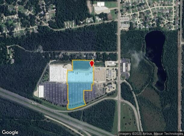
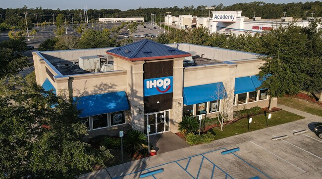
Property Record
61119 Airport Rd, Slidell, LA 70460

NEARBY LISTINGS FOR SALE OR LEASE
Property Detail
61119 Airport Rd
New Orleans-Metairie, LA
Commercial Northshore Blvd
92398
LOT A CONT 11.528 ACS SEC 30 37 8 14 STIRLING SLIDELL INST NO 1292817 INST NO 1595582 INST NO 1952380
Commercialnec
St Tammany
ARE
Louisiana
2025
a
2024
11.53 AC
040711
Slidell
97,162 SF
New Orleans/Metairie/Kenner
DEMOGRAPHICS near 61119 Airport Rd
1 Mile
3 Mile
5 Mile
2024 Total Population
2,506
17,015
53,892
2029 Population
2,680
18,262
57,962
Pop Growth 2024-2029
+ 6.94%
+ 7.33%
+ 7.55%
Average Age
41
40
40
2024 Total Households
1,051
6,465
20,591
HH Growth 2024-2029
+ 6.95%
+ 7.32%
+ 7.55%
Median Household Inc
$36,447
$58,669
$56,744
Avg Household Size
2.30
2.60
2.50
2024 Avg HH Vehicles
2.00
2.00
2.00
Median Home Value
$170,766
$166,755
$173,123
Median Year Built
1993
1990
1983
Nearby Places
Map Layers
Map Styles
 Street
 Aerial
- Restaurants
- Banks
- Shops
- Fitness
- Groceries
PUBLIC TRANSPORTATION
COMMUTER RAIL
Slidell Amtrak Station (Crescent - Amtrak)
DRIVE
WALK
Distance
Slidell Amtrak Station (Crescent - Amtrak)
8 min
4.8 mi
Freight Ports
Port of New Orleans
DRIVE
WALK
Distance
Port of New Orleans
54 min
42.0 mi
SALE & LEASE HISTORY
LISTING DATE
SALE/LEASE

Sep 25, 2016
For Lease
Sep 25, 2016
For Lease
Nearby Properties
Address
Land Use
TOTAL SIZE
Lot Size
Zoning
Address
Land Use
TOTAL SIZE
Lot Size
Zoning
192,685 SF
Address
Land Use
TOTAL SIZE
Lot Size
Zoning
208,769 SF
4.72 AC
Address
Land Use
TOTAL SIZE
Lot Size
Zoning
157,561 SF
10.06 AC
Address
Land Use
TOTAL SIZE
Lot Size
Zoning
144,638 SF
0.88 AC
Address
Land Use
TOTAL SIZE
Lot Size
Zoning
137,402 SF
76.02 AC
Address
Land Use
TOTAL SIZE
Lot Size
Zoning
63,135 SF
12.49 AC
Address
Land Use
TOTAL SIZE
Lot Size
Zoning
67,517 SF
0.89 AC
Address
Land Use
TOTAL SIZE
Lot Size
Zoning
1,940 SF
1.77 AC
Address
Land Use
TOTAL SIZE
Lot Size
Zoning
54,188 SF
1.50 AC
Address
Land Use
TOTAL SIZE
Lot Size
Zoning
131,548 SF
2.99 AC
Address
Land Use
TOTAL SIZE
Lot Size
Zoning
184,551 SF
20 AC
Address
Land Use
TOTAL SIZE
Lot Size
Zoning
108,003 SF
2.59 AC
Address
Land Use
TOTAL SIZE
Lot Size
Zoning
1,729 SF
1.22 AC
Address
Land Use
TOTAL SIZE
Lot Size
Zoning
66,130 SF
3 AC
Address
Land Use
TOTAL SIZE
Lot Size
Zoning
115,776 SF
7.50 AC
Address
Land Use
TOTAL SIZE
Lot Size
Zoning
78,962 SF
4.89 AC
Address
Land Use
TOTAL SIZE
Lot Size
Zoning
68,284 SF
7.20 AC
Address
Land Use
TOTAL SIZE
Lot Size
Zoning
21.34 AC
Address
Land Use
TOTAL SIZE
Lot Size
Zoning
30,002 SF
3.41 AC
Address
Land Use
TOTAL SIZE
Lot Size
Zoning
353,130 SF
38.95 AC
Address
Land Use
TOTAL SIZE
Lot Size
Zoning
76,595 SF
7.50 AC
Address
Land Use
TOTAL SIZE
Lot Size
Zoning
34,159 SF
1.34 AC
Address
Land Use
TOTAL SIZE
Lot Size
Zoning
26,636 SF
1.06 AC
Address
Land Use
TOTAL SIZE
Lot Size
Zoning
32,375 SF
27.60 AC
Address
Land Use
TOTAL SIZE
Lot Size
Zoning
29,388 SF
3.03 AC
Address
Land Use
TOTAL SIZE
Lot Size
Zoning
15.11 AC
Address
Land Use
TOTAL SIZE
Lot Size
Zoning
24,992 SF
5 AC
Address
Land Use
TOTAL SIZE
Lot Size
Zoning
51,986 SF
10.56 AC
Address
Land Use
TOTAL SIZE
Lot Size
Zoning
18,914 SF
3.81 AC
The World's #1 Commercial Real Estate Marketplace
Connect with us
© 2026 CoStar Group
The information above has been obtained from sources believed reliable. While we do not doubt its accuracy we have not verified it and make no guarantee, warranty or representation about it. It is your responsibility to independently confirm its accuracy and completeness. Any projections, opinions, assumptions, or estimates used are for example only and do not represent the current or future performance of the property. The value of this transaction to you depends on tax and other factors which should be evaluated by your tax, financial, and legal advisors. You and your advisors should conduct a careful, independent investigation of the property to determine to your satisfaction the suitability of the property for your needs.