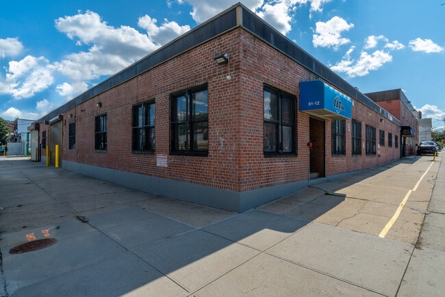
Property Record
6112 32Nd Ave, Woodside, NY 11377

Save to a Folder
{{folder.Name}}
{{folder.ListingIds.length}} Properties
{{folder.ListingIds.length}} Property
Create a New Folder
Property Detail
6112 32Nd Ave
01162-0007
Queens
Industrialgeneral
New York
M1-1
7
B and X Area of moderate flood hazard, usually the area between the limits of the 100-year and 500-year floods.
0.29 AC
2025
Northwest Queens
2026
Long Island (New York)
029700
New York-Jersey City-White Plains, NY-NJ
10,925 SF
NEARBY LISTINGS FOR SALE OR LEASE
DEMOGRAPHICS near 6112 32Nd Ave
1 mile
3 mile
5 mile
2025 Total Population
149,583
858,413
2,939,128
2030 Population
148,600
856,984
2,978,914
Pop Growth 2025-2030
(0.66%)
(0.17%)
+ 1.35%
Average Age
42
41
41
2025 Total Households
55,851
327,258
1,213,688
HH Growth 2025-2030
(0.81%)
+ 0.17%
+ 1.82%
Median Household Inc
$78,661
$86,464
$87,563
Avg Household Size
2.60
2.50
2.30
2025 Avg HH Vehicles
1.00
1.00
.00
Median Home Value
$677,664
$746,849
$846,963
Median Year Built
1949
1955
1956
Nearby Places
Map Layers
Map Styles
 Street
 Aerial
Layers
 Traffic
 Biking
Places
Listings with unknown addresses are not visible on the map
- Restaurants
- Banks
- Shops
- Fitness
- Groceries
PUBLIC TRANSPORTATION
TRANSIT/SUBWAY
Northern Boulevard (E - New York MTA Subway (The Subway), M - New York MTA Subway (The Subway), R - New York MTA Subway (The Subway))
Drive
Walk
Distance
Northern Boulevard (E - New York MTA Subway (The Subway), M - New York MTA Subway (The Subway), R - New York MTA Subway (The Subway))
1 min
9 min
0.5 mi
65 Street (E - New York MTA Subway (The Subway), M - New York MTA Subway (The Subway), R - New York MTA Subway (The Subway))
Drive
Walk
Distance
65 Street (E - New York MTA Subway (The Subway), M - New York MTA Subway (The Subway), R - New York MTA Subway (The Subway))
2 min
11 min
0.6 mi
46 Street (E - New York MTA Subway (The Subway), M - New York MTA Subway (The Subway), R - New York MTA Subway (The Subway))
Drive
Walk
Distance
46 Street (E - New York MTA Subway (The Subway), M - New York MTA Subway (The Subway), R - New York MTA Subway (The Subway))
3 min
14 min
0.7 mi
Woodside-61 Street (7 - New York MTA Subway (The Subway))
Drive
Walk
Distance
Woodside-61 Street (7 - New York MTA Subway (The Subway))
3 min
15 min
0.8 mi
69 Street (7 - New York MTA Subway (The Subway))
Drive
Walk
Distance
69 Street (7 - New York MTA Subway (The Subway))
3 min
15 min
0.8 mi
COMMUTER RAIL
Woodside Station (Babylon Branch - Long Island Rail Road, Far Rockaway Branch - Long Island Rail Road, Hempstead Branch - Long Island Rail Road, Long Beach Branch - Long Island Rail Road, Montauk Branch - Long Island Rail Road, Port Jefferson Branch - Long Island Rail Road, Port Washington Branch - Long Island Rail Road, Ronkonkoma Branch - Long Island Rail Road)
Drive
Walk
Distance
Woodside Station (Babylon Branch - Long Island Rail Road, Far Rockaway Branch - Long Island Rail Road, Hempstead Branch - Long Island Rail Road, Long Beach Branch - Long Island Rail Road, Montauk Branch - Long Island Rail Road, Port Jefferson Branch - Long Island Rail Road, Port Washington Branch - Long Island Rail Road, Ronkonkoma Branch - Long Island Rail Road)
3 min
15 min
0.8 mi
Hunterspoint Avenue Station (Hempstead Branch - Long Island Rail Road, Oyster Bay Branch - Long Island Rail Road)
Drive
Walk
Distance
Hunterspoint Avenue Station (Hempstead Branch - Long Island Rail Road, Oyster Bay Branch - Long Island Rail Road)
9 min
3.1 mi
AIRPORT
LaGuardia
Drive
Walk
Distance
LaGuardia
6 min
2.2 mi
John F Kennedy International
Drive
Walk
Distance
John F Kennedy International
19 min
13.5 mi
Newark Liberty International
Drive
Walk
Distance
Newark Liberty International
32 min
20.7 mi
Freight Ports
NY - Red Hook Container Terminal
Drive
Walk
Distance
NY - Red Hook Container Terminal
17 min
9.4 mi
SALE & LEASE HISTORY
LISTING DATE
SALE/LEASE

Sep 25, 2024
For Lease
Sep 11, 2020
For Sale
Jun 29, 2021
For Sale
Jun 20, 2024
For Sale
Jul 25, 2019
For Sale
Dec 02, 2022
For Sale
Aug 08, 2023
For Sale
Nearby Properties
Address
Land Use
TOTAL SIZE
Lot Size
Zoning
Address
Land Use
TOTAL SIZE
Lot Size
Zoning
5,519,372 SF
409.21 AC
C8-2
Address
Land Use
TOTAL SIZE
Lot Size
Zoning
23.16 AC
PARK
Address
Land Use
TOTAL SIZE
Lot Size
Zoning
2,230,742 SF
6.33 AC
R9
Address
Land Use
TOTAL SIZE
Lot Size
Zoning
1,258,350 SF
410.24 AC
PARK
Address
Land Use
TOTAL SIZE
Lot Size
Zoning
1,065,915 SF
2.13 AC
M16R10
Address
Land Use
TOTAL SIZE
Lot Size
Zoning
1,200,000 SF
10.24 AC
R9
Address
Land Use
TOTAL SIZE
Lot Size
Zoning
757,439 SF
0.91 AC
C1-9
Address
Land Use
TOTAL SIZE
Lot Size
Zoning
733,747 SF
0.98 AC
R10
Address
Land Use
TOTAL SIZE
Lot Size
Zoning
1,502,532 SF
6.35 AC
R7B
Address
Land Use
TOTAL SIZE
Lot Size
Zoning
714,224 SF
0.70 AC
R8
Address
Land Use
TOTAL SIZE
Lot Size
Zoning
772,163 SF
5.24 AC
C4-5X
Address
Land Use
TOTAL SIZE
Lot Size
Zoning
984,760 SF
2.04 AC
M3-1
Address
Land Use
TOTAL SIZE
Lot Size
Zoning
661,538 SF
11.26 AC
R7-2
Address
Land Use
TOTAL SIZE
Lot Size
Zoning
407,259 SF
0.93 AC
C5-2
Address
Land Use
TOTAL SIZE
Lot Size
Zoning
527,900 SF
0.57 AC
R10
Address
Land Use
TOTAL SIZE
Lot Size
Zoning
1,359,110 SF
1.89 AC
C5-3
Address
Land Use
TOTAL SIZE
Lot Size
Zoning
882,579 SF
0.51 AC
M16R10
Address
Land Use
TOTAL SIZE
Lot Size
Zoning
1,292,074 SF
C4-2F
Address
Land Use
TOTAL SIZE
Lot Size
Zoning
334,675 SF
10.24 AC
R9
Address
Land Use
TOTAL SIZE
Lot Size
Zoning
538,454 SF
2.37 AC
R9
Address
Land Use
TOTAL SIZE
Lot Size
Zoning
207.09 AC
PARK
Address
Land Use
TOTAL SIZE
Lot Size
Zoning
234,891 SF
3.17 AC
C4-5X
Address
Land Use
TOTAL SIZE
Lot Size
Zoning
804,200 SF
5.28 AC
R7-2
Address
Land Use
TOTAL SIZE
Lot Size
Zoning
505,416 SF
M16R10
Address
Land Use
TOTAL SIZE
Lot Size
Zoning
710,860 SF
1.52 AC
M15R9
Address
Land Use
TOTAL SIZE
Lot Size
Zoning
948,188 SF
1.30 AC
M16R10
Address
Land Use
TOTAL SIZE
Lot Size
Zoning
948 SF
282.37 AC
PARK
Address
Land Use
TOTAL SIZE
Lot Size
Zoning
219,846 SF
10.93 AC
R8
Address
Land Use
TOTAL SIZE
Lot Size
Zoning
302,854 SF
0.33 AC
C1-9
Address
Land Use
TOTAL SIZE
Lot Size
Zoning
422,128 SF
0.83 AC
R9
The World's #1 Commercial Real Estate Marketplace
Connect with us
© 2026 CoStar Group
The information above has been obtained from sources believed reliable. While we do not doubt its accuracy we have not verified it and make no guarantee, warranty or representation about it. It is your responsibility to independently confirm its accuracy and completeness. Any projections, opinions, assumptions, or estimates used are for example only and do not represent the current or future performance of the property. The value of this transaction to you depends on tax and other factors which should be evaluated by your tax, financial, and legal advisors. You and your advisors should conduct a careful, independent investigation of the property to determine to your satisfaction the suitability of the property for your needs.