Property Record
6112 N State Highway 349, Midland, TX 79705
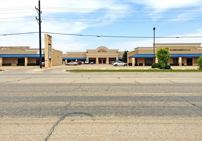

Property Detail
6112 N State Highway 349
Midland, TX
ACRES: 1.032 BLK: 004 LOT: N/2 OF 01B ADDN: 349 RANCH ESTATES SEC 11
R000203-986
Midland
Officebuilding
Texas
LR2
n/2
2025
1.03 AC
2025
Midland & Odessa
010123
Other Market Areas
4,532 SF
NEARBY LISTINGS FOR SALE OR LEASE
DEMOGRAPHICS near 6112 N State Highway 349
1 mile
3 mile
5 mile
2025 Total Population
6,291
27,459
81,887
2030 Population
7,199
30,974
90,784
Pop Growth 2025-2030
+ 14.43%
+ 12.80%
+ 10.86%
Average Age
30
34
36
2025 Total Households
2,217
10,308
30,841
HH Growth 2025-2030
+ 15.56%
+ 13.84%
+ 12.03%
Median Household Inc
$105,909
$105,471
$100,101
Avg Household Size
2.80
2.60
2.60
2025 Avg HH Vehicles
2.00
2.00
2.00
Median Home Value
$359,958
$361,529
$343,313
Median Year Built
2011
2010
1985
Nearby Places
Map Layers
Map Styles
 Street
 Aerial
Transit
 Traffic
 Biking
Places
Listings with unknown addresses are not visible on the map
- Restaurants
- Banks
- Shops
- Fitness
- Groceries
PUBLIC TRANSPORTATION
AIRPORT
Midland International Air And Space Port
Drive
Walk
Distance
Midland International Air And Space Port
22 min
16.3 mi
Freight Ports
Calhoun Port
Drive
Walk
Distance
Calhoun Port
531 min
475.9 mi
SALE & LEASE HISTORY
LISTING DATE
SALE/LEASE

Sep 11, 2017
For Lease
Oct 28, 2016
For Sale
Oct 28, 2016
For Lease
Nearby Properties
Address
Land Use
TOTAL SIZE
Lot Size
Zoning
Address
Land Use
TOTAL SIZE
Lot Size
Zoning
9,988 SF
17.46 AC
Address
Land Use
TOTAL SIZE
Lot Size
Zoning
8,290 SF
12.79 AC
Address
Land Use
TOTAL SIZE
Lot Size
Zoning
218,400 SF
14.12 AC
Address
Land Use
TOTAL SIZE
Lot Size
Zoning
5,178 SF
16.66 AC
PDOC
Address
Land Use
TOTAL SIZE
Lot Size
Zoning
94,059 SF
15.95 AC
PDMX
Address
Land Use
TOTAL SIZE
Lot Size
Zoning
37,220 SF
7.95 AC
O2
Address
Land Use
TOTAL SIZE
Lot Size
Zoning
7,793 SF
15.51 AC
Address
Land Use
TOTAL SIZE
Lot Size
Zoning
1,770 SF
19.28 AC
PDHD
Address
Land Use
TOTAL SIZE
Lot Size
Zoning
249,810 SF
9.42 AC
Address
Land Use
TOTAL SIZE
Lot Size
Zoning
12,916 SF
0.71 AC
MF1
Address
Land Use
TOTAL SIZE
Lot Size
Zoning
7,526 SF
12 AC
MF1
Address
Land Use
TOTAL SIZE
Lot Size
Zoning
46,010 SF
13.02 AC
PDOC
Address
Land Use
TOTAL SIZE
Lot Size
Zoning
2,049 SF
8.79 AC
MF1
Address
Land Use
TOTAL SIZE
Lot Size
Zoning
904 SF
11.34 AC
MF1
Address
Land Use
TOTAL SIZE
Lot Size
Zoning
1,980 SF
10.25 AC
MF1
Address
Land Use
TOTAL SIZE
Lot Size
Zoning
1,206 SF
4.08 AC
Address
Land Use
TOTAL SIZE
Lot Size
Zoning
161,148 SF
3.83 AC
MF2
Address
Land Use
TOTAL SIZE
Lot Size
Zoning
960 SF
8 AC
MF1
Address
Land Use
TOTAL SIZE
Lot Size
Zoning
247,533 SF
8 AC
PDOC
Address
Land Use
TOTAL SIZE
Lot Size
Zoning
352 SF
4.50 AC
O2
Address
Land Use
TOTAL SIZE
Lot Size
Zoning
82,265 SF
8.44 AC
PDHD
Address
Land Use
TOTAL SIZE
Lot Size
Zoning
16,016 SF
2 AC
Address
Land Use
TOTAL SIZE
Lot Size
Zoning
15,408 SF
2.16 AC
PDOC
Address
Land Use
TOTAL SIZE
Lot Size
Zoning
25,000 SF
4.87 AC
PDOC
Address
Land Use
TOTAL SIZE
Lot Size
Zoning
81,200 SF
5.19 AC
Address
Land Use
TOTAL SIZE
Lot Size
Zoning
23,136 SF
6.61 AC
MF1
Address
Land Use
TOTAL SIZE
Lot Size
Zoning
360 SF
10.02 AC
PDHD
Address
Land Use
TOTAL SIZE
Lot Size
Zoning
42,761 SF
3.65 AC
O1
Address
Land Use
TOTAL SIZE
Lot Size
Zoning
30,225 SF
2.88 AC
PDOC
The World's #1 Commercial Real Estate Marketplace
Connect with us
© 2026 CoStar Group
The information above has been obtained from sources believed reliable. While we do not doubt its accuracy we have not verified it and make no guarantee, warranty or representation about it. It is your responsibility to independently confirm its accuracy and completeness. Any projections, opinions, assumptions, or estimates used are for example only and do not represent the current or future performance of the property. The value of this transaction to you depends on tax and other factors which should be evaluated by your tax, financial, and legal advisors. You and your advisors should conduct a careful, independent investigation of the property to determine to your satisfaction the suitability of the property for your needs.