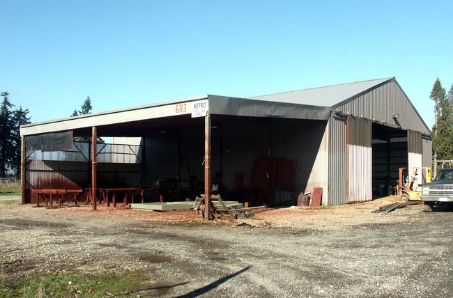
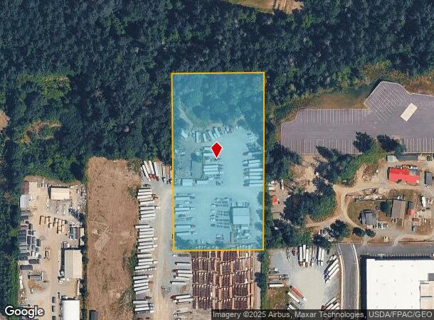
Property Record
6113 176Th St E, Puyallup, WA 98375
NEARBY LISTINGS FOR SALE OR LEASE
Property Detail
6113 176Th St E
041930-3008
SECTION 30 TOWNSHIP 19 RANGE 04 QUARTER 34 N 1/2 OF E 1/2 OF E 1/2 OF SE OF SW SEG F 3174 T/E 1985 FLTWD SANDALWOOD S#FL2AF21316037 27X56 AFN 9906280429 (MH ASSESSED ON P50000-17395)
Commercialnec
Pierce
X
Washington
53053C0576E
5 AC
2024
Puyallup/S Hill
2025
Seattle/Puget Sound
073127
Seattle-Tacoma-Bellevue, WA
3,600 SF
DEMOGRAPHICS near 6113 176Th St E
1 Mile
3 Mile
5 Mile
2024 Total Population
5,142
80,037
191,966
2029 Population
5,278
81,696
197,320
Pop Growth 2024-2029
+ 2.64%
+ 2.07%
+ 2.79%
Average Age
34
36
37
2024 Total Households
1,618
25,688
64,988
HH Growth 2024-2029
+ 2.53%
+ 2.09%
+ 2.87%
Median Household Inc
$78,982
$100,395
$94,599
Avg Household Size
3.00
3.00
2.90
2024 Avg HH Vehicles
2.00
2.00
2.00
Median Home Value
$341,362
$426,081
$427,894
Median Year Built
2000
1999
1995
Nearby Places
Map Layers
Map Styles
 Street
 Aerial
- Restaurants
- Banks
- Shops
- Fitness
- Groceries
PUBLIC TRANSPORTATION
AIRPORT
Seattle-Tacoma International
DRIVE
WALK
Distance
Seattle-Tacoma International
52 min
32.7 mi
Freight Ports
Port of Tacoma
DRIVE
WALK
Distance
Port of Tacoma
25 min
14.0 mi
Nearby Properties
Address
Land Use
TOTAL SIZE
Lot Size
Zoning
Address
Land Use
TOTAL SIZE
Lot Size
Zoning
1,381,439 SF
209.68 AC
EC
Address
Land Use
TOTAL SIZE
Lot Size
Zoning
492,365 SF
24.33 AC
EC
Address
Land Use
TOTAL SIZE
Lot Size
Zoning
1,110,154 SF
53.99 AC
EC
Address
Land Use
TOTAL SIZE
Lot Size
Zoning
782,773 SF
53.33 AC
Address
Land Use
TOTAL SIZE
Lot Size
Zoning
77,520 SF
25 AC
EC
Address
Land Use
TOTAL SIZE
Lot Size
Zoning
753,069 SF
40.94 AC
Address
Land Use
TOTAL SIZE
Lot Size
Zoning
862,167 SF
45.51 AC
EC
Address
Land Use
TOTAL SIZE
Lot Size
Zoning
1,118,480 SF
75.62 AC
Address
Land Use
TOTAL SIZE
Lot Size
Zoning
611,206 SF
30.76 AC
Address
Land Use
TOTAL SIZE
Lot Size
Zoning
305,680 SF
14.48 AC
Address
Land Use
TOTAL SIZE
Lot Size
Zoning
891,600 SF
48.79 AC
EC
Address
Land Use
TOTAL SIZE
Lot Size
Zoning
533,393 SF
26.48 AC
EC
Address
Land Use
TOTAL SIZE
Lot Size
Zoning
449,359 SF
37.20 AC
EC
Address
Land Use
TOTAL SIZE
Lot Size
Zoning
522,832 SF
33.82 AC
EC
Address
Land Use
TOTAL SIZE
Lot Size
Zoning
645,993 SF
62.57 AC
EC
Address
Land Use
TOTAL SIZE
Lot Size
Zoning
229,782 SF
13.23 AC
Address
Land Use
TOTAL SIZE
Lot Size
Zoning
477,120 SF
27.79 AC
Address
Land Use
TOTAL SIZE
Lot Size
Zoning
405,040 SF
26.44 AC
Address
Land Use
TOTAL SIZE
Lot Size
Zoning
352,930 SF
20.68 AC
Address
Land Use
TOTAL SIZE
Lot Size
Zoning
153,138 SF
9.11 AC
CC
Address
Land Use
TOTAL SIZE
Lot Size
Zoning
153,993 SF
8.83 AC
Address
Land Use
TOTAL SIZE
Lot Size
Zoning
312,225 SF
13.66 AC
EC
Address
Land Use
TOTAL SIZE
Lot Size
Zoning
218,262 SF
3.58 AC
MUD
Address
Land Use
TOTAL SIZE
Lot Size
Zoning
192,163 SF
24.26 AC
EC
Address
Land Use
TOTAL SIZE
Lot Size
Zoning
120,124 SF
16.78 AC
MSF
Address
Land Use
TOTAL SIZE
Lot Size
Zoning
300,942 SF
18.82 AC
EC
Address
Land Use
TOTAL SIZE
Lot Size
Zoning
171,185 SF
15.32 AC
EC
Address
Land Use
TOTAL SIZE
Lot Size
Zoning
311,452 SF
18.90 AC
EC
Address
Land Use
TOTAL SIZE
Lot Size
Zoning
175,315 SF
4.81 AC
NCOR
Address
Land Use
TOTAL SIZE
Lot Size
Zoning
267,365 SF
13.10 AC
EC
The World's #1 Commercial Real Estate Marketplace
Connect with us
© 2025 CoStar Group
The information above has been obtained from sources believed reliable. While we do not doubt its accuracy we have not verified it and make no guarantee, warranty or representation about it. It is your responsibility to independently confirm its accuracy and completeness. Any projections, opinions, assumptions, or estimates used are for example only and do not represent the current or future performance of the property. The value of this transaction to you depends on tax and other factors which should be evaluated by your tax, financial, and legal advisors. You and your advisors should conduct a careful, independent investigation of the property to determine to your satisfaction the suitability of the property for your needs.