Property Record
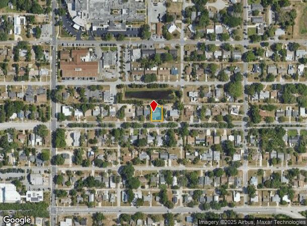
6115 Central Ave, New Port Richey, FL 34653
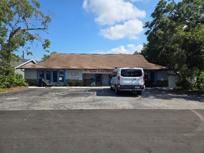

This Property Is For Sale
NEARBY LISTINGS FOR SALE OR LEASE
Property Detail
6115 Central Ave
Tampa-St. Petersburg-Clearwater, FL
Town Of New Port Richey
04-26-16-0030-05800-0250
CITY OF NEW PORT RICHEY PB 4 PG 49 LOTS 25 26 & 27 BLOCK 58
Officebuilding
Pasco
X
Florida
12101C0189G
25
2024
0.17 AC
2025
Pasco County
031401
Tampa/St Petersburg
2,635 SF
DEMOGRAPHICS near 6115 Central Ave
1 Mile
3 Mile
5 Mile
2024 Total Population
14,457
90,560
194,556
2029 Population
20,048
125,521
270,307
Pop Growth 2024-2029
+ 38.67%
+ 38.61%
+ 38.94%
Average Age
45
45
44
2024 Total Households
6,685
40,093
83,685
HH Growth 2024-2029
+ 37.35%
+ 37.39%
+ 37.76%
Median Household Inc
$45,926
$52,083
$56,258
Avg Household Size
2.10
2.20
2.30
2024 Avg HH Vehicles
1.00
2.00
2.00
Median Home Value
$225,872
$261,402
$264,670
Median Year Built
1979
1979
1980
Nearby Places
- Restaurants
- Banks
- Shops
- Fitness
- Groceries
PUBLIC TRANSPORTATION
AIRPORT
St Pete-Clearwater International
DRIVE
WALK
Distance
St Pete-Clearwater International
43 min
27.1 mi
Tampa International
DRIVE
WALK
Distance
Tampa International
50 min
33.4 mi
Freight Ports
Port of Tampa Bay
DRIVE
WALK
Distance
Port of Tampa Bay
63 min
39.0 mi
Nearby Properties
Address
Land Use
TOTAL SIZE
Lot Size
Zoning
Address
Land Use
TOTAL SIZE
Lot Size
Zoning
799,241 SF
88.92 AC
PUD
Address
Land Use
TOTAL SIZE
Lot Size
Zoning
248,561 SF
14.17 AC
C
Address
Land Use
TOTAL SIZE
Lot Size
Zoning
241,429 SF
37.59 AC
C
Address
Land Use
TOTAL SIZE
Lot Size
Zoning
351,012 SF
23.51 AC
MF2
Address
Land Use
TOTAL SIZE
Lot Size
Zoning
220,843 SF
35.13 AC
C2
Address
Land Use
TOTAL SIZE
Lot Size
Zoning
416,037 SF
50.65 AC
C1
Address
Land Use
TOTAL SIZE
Lot Size
Zoning
141,740 SF
22.84 AC
PO1
Address
Land Use
TOTAL SIZE
Lot Size
Zoning
162,716 SF
16.56 AC
MF1
Address
Land Use
TOTAL SIZE
Lot Size
Zoning
171,378 SF
17.35 AC
MF1
Address
Land Use
TOTAL SIZE
Lot Size
Zoning
149,162 SF
3.10 AC
C
Address
Land Use
TOTAL SIZE
Lot Size
Zoning
193,971 SF
4.50 AC
C1
Address
Land Use
TOTAL SIZE
Lot Size
Zoning
163,106 SF
13.97 AC
C
Address
Land Use
TOTAL SIZE
Lot Size
Zoning
122,037 SF
13.83 AC
MF1
Address
Land Use
TOTAL SIZE
Lot Size
Zoning
121,284 SF
10.25 AC
MF1
Address
Land Use
TOTAL SIZE
Lot Size
Zoning
91,660 SF
16.29 AC
C
Address
Land Use
TOTAL SIZE
Lot Size
Zoning
135,600 SF
13.34 AC
MF1
Address
Land Use
TOTAL SIZE
Lot Size
Zoning
309,759 SF
65.19 AC
AC
Address
Land Use
TOTAL SIZE
Lot Size
Zoning
112,703 SF
8.43 AC
C2
Address
Land Use
TOTAL SIZE
Lot Size
Zoning
183,139 SF
19.66 AC
C2
Address
Land Use
TOTAL SIZE
Lot Size
Zoning
16,510 SF
41.69 AC
R1
Address
Land Use
TOTAL SIZE
Lot Size
Zoning
142,856 SF
20 AC
C
Address
Land Use
TOTAL SIZE
Lot Size
Zoning
82,047 SF
21.48 AC
MF2
Address
Land Use
TOTAL SIZE
Lot Size
Zoning
133,304 SF
13.48 AC
C2
Address
Land Use
TOTAL SIZE
Lot Size
Zoning
76,160 SF
6.74 AC
MPUD
Address
Land Use
TOTAL SIZE
Lot Size
Zoning
81,272 SF
47.25 AC
MF2
Address
Land Use
TOTAL SIZE
Lot Size
Zoning
220,024 SF
25.72 AC
C1
Address
Land Use
TOTAL SIZE
Lot Size
Zoning
22,216 SF
7.20 AC
C2
Address
Land Use
TOTAL SIZE
Lot Size
Zoning
212,308 SF
10.91 AC
MF2
Address
Land Use
TOTAL SIZE
Lot Size
Zoning
41,156 SF
2.26 AC
C
Address
Land Use
TOTAL SIZE
Lot Size
Zoning
63,297 SF
7.28 AC
C2
The World's #1 Commercial Real Estate Marketplace
Connect with us
© 2025 CoStar Group
The information above has been obtained from sources believed reliable. While we do not doubt its accuracy we have not verified it and make no guarantee, warranty or representation about it. It is your responsibility to independently confirm its accuracy and completeness. Any projections, opinions, assumptions, or estimates used are for example only and do not represent the current or future performance of the property. The value of this transaction to you depends on tax and other factors which should be evaluated by your tax, financial, and legal advisors. You and your advisors should conduct a careful, independent investigation of the property to determine to your satisfaction the suitability of the property for your needs.