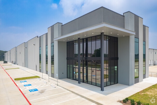
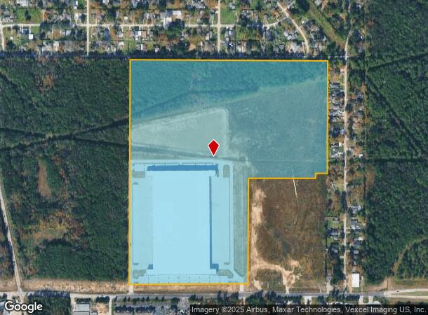
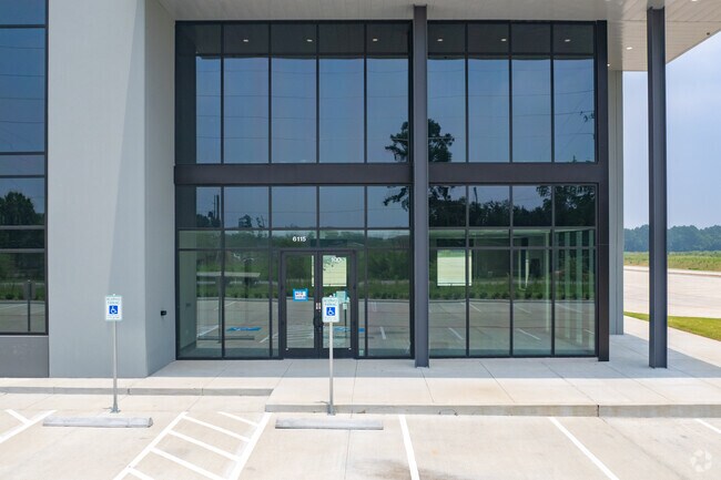
Property Record
6115 Greens Rd, Humble, TX 77396
NEARBY LISTINGS FOR SALE OR LEASE
Property Detail
6115 Greens Rd
Houston-The Woodlands-Sugar Land, TX
Nexus Logistics Park
1464500010003
RES A1 BLK 1 NEXUS LOGISTICS PARK
Outdoorrecreationbeachmountaindesert
Harris
2024
Texas
2025
76.97 AC
241501
North Hardy Toll Road
567,528 SF
Houston
DEMOGRAPHICS near 6115 Greens Rd
1 Mile
3 Mile
5 Mile
2024 Total Population
5,078
41,019
142,221
2029 Population
5,151
41,328
144,823
Pop Growth 2024-2029
+ 1.44%
+ 0.75%
+ 1.83%
Average Age
33
34
34
2024 Total Households
1,527
13,094
44,882
HH Growth 2024-2029
+ 1.05%
+ 0.44%
+ 1.71%
Median Household Inc
$50,299
$59,307
$58,018
Avg Household Size
3.00
3.00
3.10
2024 Avg HH Vehicles
2.00
2.00
2.00
Median Home Value
$125,420
$189,358
$172,716
Median Year Built
1997
1996
1993
Nearby Places
Map Layers
Map Styles
 Street
 Aerial
- Restaurants
- Banks
- Shops
- Fitness
- Groceries
PUBLIC TRANSPORTATION
AIRPORT
George Bush Intcntl/Houston
DRIVE
WALK
Distance
George Bush Intcntl/Houston
8 min
4.8 mi
William P Hobby
DRIVE
WALK
Distance
William P Hobby
43 min
27.1 mi
Freight Ports
Port of Houston
DRIVE
WALK
Distance
Port of Houston
32 min
20.8 mi
SALE & LEASE HISTORY
LISTING DATE
SALE/LEASE

Sep 13, 2022
For Lease
Nearby Properties
Address
Land Use
TOTAL SIZE
Lot Size
Zoning
Address
Land Use
TOTAL SIZE
Lot Size
Zoning
1,213,044 SF
69.99 AC
Address
Land Use
TOTAL SIZE
Lot Size
Zoning
1,767,053 SF
88.85 AC
Address
Land Use
TOTAL SIZE
Lot Size
Zoning
785,390 SF
66.02 AC
Address
Land Use
TOTAL SIZE
Lot Size
Zoning
685,400 SF
38.82 AC
Address
Land Use
TOTAL SIZE
Lot Size
Zoning
621,700 SF
67.57 AC
Address
Land Use
TOTAL SIZE
Lot Size
Zoning
514,500 SF
40.85 AC
Address
Land Use
TOTAL SIZE
Lot Size
Zoning
306,652 SF
10.67 AC
Address
Land Use
TOTAL SIZE
Lot Size
Zoning
379,570 SF
30.12 AC
Address
Land Use
TOTAL SIZE
Lot Size
Zoning
429,750 SF
24.74 AC
Address
Land Use
TOTAL SIZE
Lot Size
Zoning
320,798 SF
14.25 AC
Address
Land Use
TOTAL SIZE
Lot Size
Zoning
391,060 SF
32.42 AC
Address
Land Use
TOTAL SIZE
Lot Size
Zoning
338,700 SF
22.99 AC
Address
Land Use
TOTAL SIZE
Lot Size
Zoning
361,919 SF
23.59 AC
Address
Land Use
TOTAL SIZE
Lot Size
Zoning
448,760 SF
8.46 AC
Address
Land Use
TOTAL SIZE
Lot Size
Zoning
260,427 SF
4.50 AC
Address
Land Use
TOTAL SIZE
Lot Size
Zoning
334,510 SF
23.54 AC
Address
Land Use
TOTAL SIZE
Lot Size
Zoning
320,200 SF
19.56 AC
Address
Land Use
TOTAL SIZE
Lot Size
Zoning
73,500 SF
115.96 AC
Address
Land Use
TOTAL SIZE
Lot Size
Zoning
449,858 SF
22.20 AC
Address
Land Use
TOTAL SIZE
Lot Size
Zoning
207,720 SF
12.33 AC
Address
Land Use
TOTAL SIZE
Lot Size
Zoning
321,604 SF
16.68 AC
Address
Land Use
TOTAL SIZE
Lot Size
Zoning
246,712 SF
13.33 AC
Address
Land Use
TOTAL SIZE
Lot Size
Zoning
309,744 SF
21.50 AC
Address
Land Use
TOTAL SIZE
Lot Size
Zoning
276,464 SF
18.79 AC
Address
Land Use
TOTAL SIZE
Lot Size
Zoning
227,400 SF
19.37 AC
Address
Land Use
TOTAL SIZE
Lot Size
Zoning
262,010 SF
12.64 AC
Address
Land Use
TOTAL SIZE
Lot Size
Zoning
170,407 SF
26.31 AC
Address
Land Use
TOTAL SIZE
Lot Size
Zoning
281,252 SF
8 AC
Address
Land Use
TOTAL SIZE
Lot Size
Zoning
215,879 SF
7.30 AC
The World's #1 Commercial Real Estate Marketplace
Connect with us
© 2025 CoStar Group
The information above has been obtained from sources believed reliable. While we do not doubt its accuracy we have not verified it and make no guarantee, warranty or representation about it. It is your responsibility to independently confirm its accuracy and completeness. Any projections, opinions, assumptions, or estimates used are for example only and do not represent the current or future performance of the property. The value of this transaction to you depends on tax and other factors which should be evaluated by your tax, financial, and legal advisors. You and your advisors should conduct a careful, independent investigation of the property to determine to your satisfaction the suitability of the property for your needs.