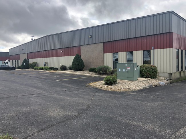
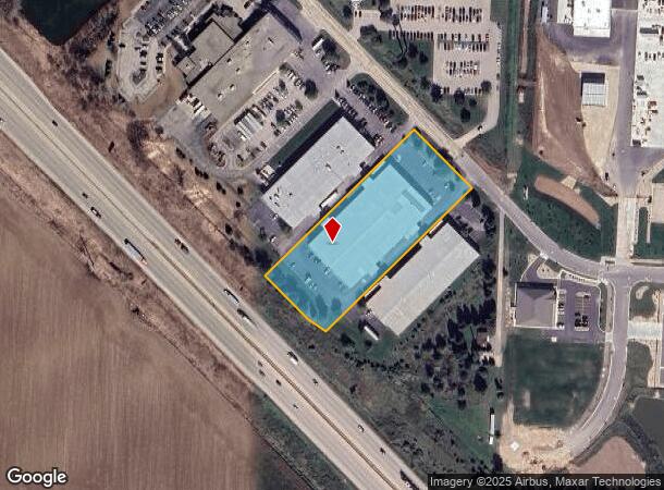
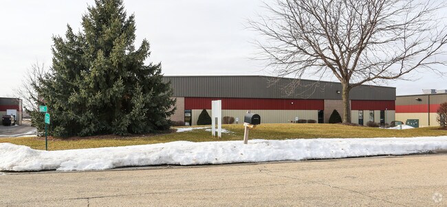
Property Record
6115-6129 Pepsi Way, Windsor, WI 53598
NEARBY LISTINGS FOR SALE OR LEASE
Property Detail
6115-6129 Pepsi Way
Madison, WI
Highway 19 Commercial Plat
0810-052-1000-9
HIGHWAY 19 COMMERCIAL PLAT-2ND ADDITION LOT 15 SUBJ TO ESMT IN DOC # 4653104 SUB J TO & TOG W/ACCESS ESMT IN DOC #5006059
Commercialnec
Dane
X
Wisconsin
55025C0254H
15
2024
2.71 AC
2024
Northeast Madison
013202
Milwaukee/Madison
DEMOGRAPHICS near 6115-6129 Pepsi Way
1 Mile
3 Mile
5 Mile
2024 Total Population
676
15,453
74,744
2029 Population
702
16,215
77,764
Pop Growth 2024-2029
+ 3.85%
+ 4.93%
+ 4.04%
Average Age
41
38
39
2024 Total Households
272
5,838
30,770
HH Growth 2024-2029
+ 3.68%
+ 4.98%
+ 4.20%
Median Household Inc
$89,338
$108,780
$79,704
Avg Household Size
2.40
2.60
2.40
2024 Avg HH Vehicles
2.00
2.00
2.00
Median Home Value
$342,253
$354,076
$299,540
Median Year Built
1988
1996
1991
Nearby Places
Map Layers
Map Styles
 Street
 Aerial
- Restaurants
- Banks
- Shops
- Fitness
- Groceries
PUBLIC TRANSPORTATION
AIRPORT
Dane County Regional/Truax Field
DRIVE
WALK
Distance
Dane County Regional/Truax Field
14 min
7.3 mi
Freight Ports
Port Milwaukee
DRIVE
WALK
Distance
Port Milwaukee
95 min
81.4 mi
SALE & LEASE HISTORY
LISTING DATE
SALE/LEASE

Sep 25, 2016
For Lease
Nov 06, 2019
For Lease
Nearby Properties
Address
Land Use
TOTAL SIZE
Lot Size
Zoning
Address
Land Use
TOTAL SIZE
Lot Size
Zoning
385,400 SF
62.07 AC
IL
Address
Land Use
TOTAL SIZE
Lot Size
Zoning
48.24 AC
Address
Land Use
TOTAL SIZE
Lot Size
Zoning
107,751 SF
22.34 AC
IL
Address
Land Use
TOTAL SIZE
Lot Size
Zoning
Address
Land Use
TOTAL SIZE
Lot Size
Zoning
37.54 AC
Address
Land Use
TOTAL SIZE
Lot Size
Zoning
24.70 AC
Address
Land Use
TOTAL SIZE
Lot Size
Zoning
Address
Land Use
TOTAL SIZE
Lot Size
Zoning
Address
Land Use
TOTAL SIZE
Lot Size
Zoning
3.77 AC
Address
Land Use
TOTAL SIZE
Lot Size
Zoning
16.64 AC
Address
Land Use
TOTAL SIZE
Lot Size
Zoning
11.01 AC
C2
Address
Land Use
TOTAL SIZE
Lot Size
Zoning
13.27 AC
ETZ
Address
Land Use
TOTAL SIZE
Lot Size
Zoning
137,665 SF
9.39 AC
IL
Address
Land Use
TOTAL SIZE
Lot Size
Zoning
20.59 AC
C2
Address
Land Use
TOTAL SIZE
Lot Size
Zoning
3.60 AC
Address
Land Use
TOTAL SIZE
Lot Size
Zoning
14.08 AC
IL
Address
Land Use
TOTAL SIZE
Lot Size
Zoning
2.59 AC
Address
Land Use
TOTAL SIZE
Lot Size
Zoning
8.19 AC
Address
Land Use
TOTAL SIZE
Lot Size
Zoning
122,038 SF
9.03 AC
IL
Address
Land Use
TOTAL SIZE
Lot Size
Zoning
14.75 AC
Address
Land Use
TOTAL SIZE
Lot Size
Zoning
12.30 AC
C2
Address
Land Use
TOTAL SIZE
Lot Size
Zoning
3.72 AC
R-4
Address
Land Use
TOTAL SIZE
Lot Size
Zoning
14.52 AC
ETZ
Address
Land Use
TOTAL SIZE
Lot Size
Zoning
Address
Land Use
TOTAL SIZE
Lot Size
Zoning
47,012 SF
10.92 AC
IG
Address
Land Use
TOTAL SIZE
Lot Size
Zoning
Address
Land Use
TOTAL SIZE
Lot Size
Zoning
38.60 AC
Address
Land Use
TOTAL SIZE
Lot Size
Zoning
7.71 AC
ETZ
Address
Land Use
TOTAL SIZE
Lot Size
Zoning
3.72 AC
C2
Address
Land Use
TOTAL SIZE
Lot Size
Zoning
6.63 AC
The World's #1 Commercial Real Estate Marketplace
Connect with us
© 2025 CoStar Group
The information above has been obtained from sources believed reliable. While we do not doubt its accuracy we have not verified it and make no guarantee, warranty or representation about it. It is your responsibility to independently confirm its accuracy and completeness. Any projections, opinions, assumptions, or estimates used are for example only and do not represent the current or future performance of the property. The value of this transaction to you depends on tax and other factors which should be evaluated by your tax, financial, and legal advisors. You and your advisors should conduct a careful, independent investigation of the property to determine to your satisfaction the suitability of the property for your needs.