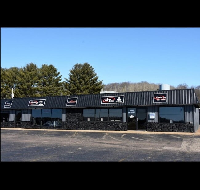
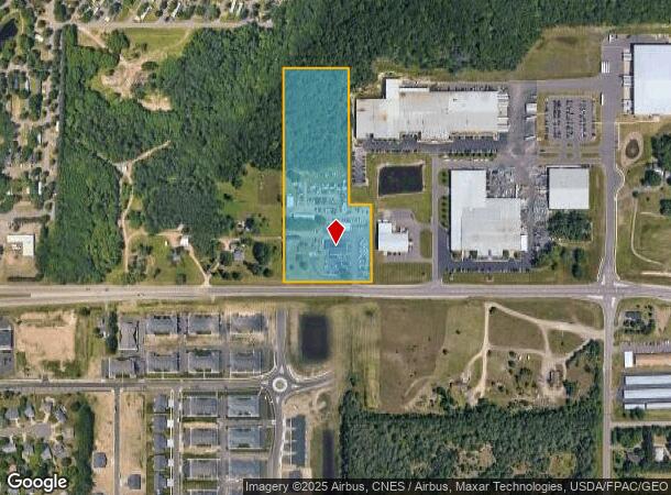
Property Record
6118 Us Highway 12, Eau Claire, WI 54701

NEARBY LISTINGS FOR SALE OR LEASE
Property Detail
6118 Us Highway 12
Eau Claire, WI
Csm No. 2747
18024-2-270925-130-9000
LOT 1 CSM 2747 (VOL 15 P 213 #1040102)
Commercialnec
Eau Claire
X
Wisconsin
55017C0750E
1
2024
9.17 AC
2024
Eau Claire/Menomonie
000402
Other Market Areas
DEMOGRAPHICS near 6118 Us Highway 12
1 Mile
3 Mile
5 Mile
2024 Total Population
3,378
24,577
68,169
2029 Population
3,595
25,864
71,034
Pop Growth 2024-2029
+ 6.42%
+ 5.24%
+ 4.20%
Average Age
40
41
39
2024 Total Households
1,436
10,658
27,905
HH Growth 2024-2029
+ 6.55%
+ 5.30%
+ 4.33%
Median Household Inc
$57,958
$66,518
$63,245
Avg Household Size
2.30
2.20
2.20
2024 Avg HH Vehicles
2.00
2.00
2.00
Median Home Value
$150,641
$256,364
$243,843
Median Year Built
1993
1991
1977
Nearby Places
Map Layers
Map Styles
 Street
 Aerial
- Restaurants
- Banks
- Shops
- Fitness
- Groceries
SALE & LEASE HISTORY
LISTING DATE
SALE/LEASE

Sep 16, 2024
For Lease
Jan 08, 2024
For Sale
Nearby Properties
Address
Land Use
TOTAL SIZE
Lot Size
Zoning
Address
Land Use
TOTAL SIZE
Lot Size
Zoning
10.07 AC
FAIRFAX CO
Address
Land Use
TOTAL SIZE
Lot Size
Zoning
520,119 SF
42.39 AC
C3
Address
Land Use
TOTAL SIZE
Lot Size
Zoning
4.28 AC
Address
Land Use
TOTAL SIZE
Lot Size
Zoning
4.94 AC
Address
Land Use
TOTAL SIZE
Lot Size
Zoning
21.41 AC
Address
Land Use
TOTAL SIZE
Lot Size
Zoning
2.70 AC
Address
Land Use
TOTAL SIZE
Lot Size
Zoning
Address
Land Use
TOTAL SIZE
Lot Size
Zoning
207,978 SF
24.47 AC
C3P
Address
Land Use
TOTAL SIZE
Lot Size
Zoning
94,173 SF
9.36 AC
C3
Address
Land Use
TOTAL SIZE
Lot Size
Zoning
13.19 AC
C
Address
Land Use
TOTAL SIZE
Lot Size
Zoning
132,943 SF
11.26 AC
Address
Land Use
TOTAL SIZE
Lot Size
Zoning
4.89 AC
FAIRFAX CO
Address
Land Use
TOTAL SIZE
Lot Size
Zoning
200,880 SF
14.86 AC
C3P
Address
Land Use
TOTAL SIZE
Lot Size
Zoning
173,473 SF
14.38 AC
C3P
Address
Land Use
TOTAL SIZE
Lot Size
Zoning
96,149 SF
5.92 AC
R3P
Address
Land Use
TOTAL SIZE
Lot Size
Zoning
169,740 SF
13.16 AC
C3P
Address
Land Use
TOTAL SIZE
Lot Size
Zoning
4.35 AC
Address
Land Use
TOTAL SIZE
Lot Size
Zoning
13.26 AC
I
Address
Land Use
TOTAL SIZE
Lot Size
Zoning
92,178 SF
3.81 AC
C3P
Address
Land Use
TOTAL SIZE
Lot Size
Zoning
85,790 SF
5.68 AC
C3
Address
Land Use
TOTAL SIZE
Lot Size
Zoning
400 SF
33.96 AC
C-R1
Address
Land Use
TOTAL SIZE
Lot Size
Zoning
18.45 AC
Address
Land Use
TOTAL SIZE
Lot Size
Zoning
0.71 AC
Address
Land Use
TOTAL SIZE
Lot Size
Zoning
50,979 SF
10.40 AC
C3P
Address
Land Use
TOTAL SIZE
Lot Size
Zoning
1.62 AC
Address
Land Use
TOTAL SIZE
Lot Size
Zoning
Address
Land Use
TOTAL SIZE
Lot Size
Zoning
92,339 SF
9.93 AC
C3
Address
Land Use
TOTAL SIZE
Lot Size
Zoning
62,964 SF
2.50 AC
R3P
Address
Land Use
TOTAL SIZE
Lot Size
Zoning
117,095 SF
18.74 AC
C3P
Address
Land Use
TOTAL SIZE
Lot Size
Zoning
11,336 SF
3.70 AC
The World's #1 Commercial Real Estate Marketplace
Connect with us
© 2025 CoStar Group
The information above has been obtained from sources believed reliable. While we do not doubt its accuracy we have not verified it and make no guarantee, warranty or representation about it. It is your responsibility to independently confirm its accuracy and completeness. Any projections, opinions, assumptions, or estimates used are for example only and do not represent the current or future performance of the property. The value of this transaction to you depends on tax and other factors which should be evaluated by your tax, financial, and legal advisors. You and your advisors should conduct a careful, independent investigation of the property to determine to your satisfaction the suitability of the property for your needs.