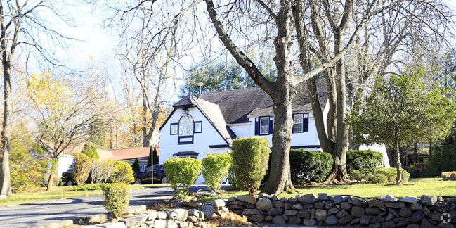
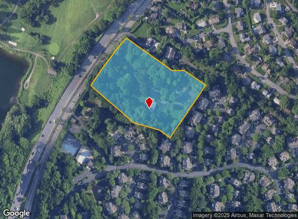
Property Record
612 E Grassy Sprain Rd, Yonkers, NY 10710

NEARBY LISTINGS FOR SALE OR LEASE
Property Detail
612 E Grassy Sprain Rd
1800-004-000-04391-000-0435
Westchester
Officebuilding
New York
X
435.000
36119C0326F
5 AC
2025
Southwest
2024
Westchester/So Connecticut
002000
New York-Jersey City-White Plains, NY-NJ
4,775 SF
DEMOGRAPHICS near 612 E Grassy Sprain Rd
1 Mile
3 Mile
5 Mile
2024 Total Population
14,490
150,632
444,372
2029 Population
14,303
147,074
432,719
Pop Growth 2024-2029
(1.29%)
(2.36%)
(2.62%)
Average Age
44
43
41
2024 Total Households
5,293
57,063
164,160
HH Growth 2024-2029
(1.45%)
(2.47%)
(2.74%)
Median Household Inc
$99,770
$123,414
$94,767
Avg Household Size
2.60
2.50
2.60
2024 Avg HH Vehicles
2.00
2.00
1.00
Median Home Value
$590,126
$630,141
$626,094
Median Year Built
1961
1955
1952
Nearby Places
- Restaurants
- Banks
- Shops
- Fitness
- Groceries
PUBLIC TRANSPORTATION
COMMUTER RAIL
Tuckahoe Station (Harlem Line - Metro-North Commuter Railroad Company (Metro-North))
DRIVE
WALK
Distance
Tuckahoe Station (Harlem Line - Metro-North Commuter Railroad Company (Metro-North))
8 min
2.7 mi
Crestwood Station (Harlem Line - Metro-North Commuter Railroad Company (Metro-North))
DRIVE
WALK
Distance
Crestwood Station (Harlem Line - Metro-North Commuter Railroad Company (Metro-North))
9 min
3.6 mi
AIRPORT
Westchester County
DRIVE
WALK
Distance
Westchester County
27 min
16.7 mi
LaGuardia
DRIVE
WALK
Distance
LaGuardia
36 min
19.2 mi
John F Kennedy International
DRIVE
WALK
Distance
John F Kennedy International
43 min
27.2 mi
Freight Ports
NY - Red Hook Container Terminal
DRIVE
WALK
Distance
NY - Red Hook Container Terminal
48 min
27.4 mi
SALE & LEASE HISTORY
LISTING DATE
SALE/LEASE

Jan 12, 2019
For Sale
Nearby Properties
Address
Land Use
TOTAL SIZE
Lot Size
Zoning
Address
Land Use
TOTAL SIZE
Lot Size
Zoning
88.45 AC
Address
Land Use
TOTAL SIZE
Lot Size
Zoning
18,000 SF
13.85 AC
A
Address
Land Use
TOTAL SIZE
Lot Size
Zoning
201,590 SF
4.13 AC
BA
Address
Land Use
TOTAL SIZE
Lot Size
Zoning
301,156 SF
13.94 AC
A
Address
Land Use
TOTAL SIZE
Lot Size
Zoning
70,737 SF
1.67 AC
BB
Address
Land Use
TOTAL SIZE
Lot Size
Zoning
66 AC
R-20
Address
Land Use
TOTAL SIZE
Lot Size
Zoning
101.99 AC
Address
Land Use
TOTAL SIZE
Lot Size
Zoning
23.97 AC
Address
Land Use
TOTAL SIZE
Lot Size
Zoning
Address
Land Use
TOTAL SIZE
Lot Size
Zoning
13.22 AC
CA
Address
Land Use
TOTAL SIZE
Lot Size
Zoning
29.81 AC
Address
Land Use
TOTAL SIZE
Lot Size
Zoning
68,911 SF
16.31 AC
Address
Land Use
TOTAL SIZE
Lot Size
Zoning
77.52 AC
A3
Address
Land Use
TOTAL SIZE
Lot Size
Zoning
64,165 SF
3.24 AC
B
Address
Land Use
TOTAL SIZE
Lot Size
Zoning
Address
Land Use
TOTAL SIZE
Lot Size
Zoning
Address
Land Use
TOTAL SIZE
Lot Size
Zoning
14.92 AC
Address
Land Use
TOTAL SIZE
Lot Size
Zoning
5,170 SF
9.08 AC
B
Address
Land Use
TOTAL SIZE
Lot Size
Zoning
98,910 SF
0.91 AC
VCR-0
Address
Land Use
TOTAL SIZE
Lot Size
Zoning
18.72 AC
Address
Land Use
TOTAL SIZE
Lot Size
Zoning
28.77 AC
Address
Land Use
TOTAL SIZE
Lot Size
Zoning
14.31 AC
Address
Land Use
TOTAL SIZE
Lot Size
Zoning
67,917 SF
6.79 AC
A4
Address
Land Use
TOTAL SIZE
Lot Size
Zoning
1,451 SF
6.97 AC
CA
Address
Land Use
TOTAL SIZE
Lot Size
Zoning
13.35 AC
Address
Land Use
TOTAL SIZE
Lot Size
Zoning
11.70 AC
R-30
Address
Land Use
TOTAL SIZE
Lot Size
Zoning
28.31 AC
Address
Land Use
TOTAL SIZE
Lot Size
Zoning
Address
Land Use
TOTAL SIZE
Lot Size
Zoning
58,450 SF
0.38 AC
VCR-2
Address
Land Use
TOTAL SIZE
Lot Size
Zoning
15.94 AC
The World's #1 Commercial Real Estate Marketplace
Connect with us
© 2025 CoStar Group
The information above has been obtained from sources believed reliable. While we do not doubt its accuracy we have not verified it and make no guarantee, warranty or representation about it. It is your responsibility to independently confirm its accuracy and completeness. Any projections, opinions, assumptions, or estimates used are for example only and do not represent the current or future performance of the property. The value of this transaction to you depends on tax and other factors which should be evaluated by your tax, financial, and legal advisors. You and your advisors should conduct a careful, independent investigation of the property to determine to your satisfaction the suitability of the property for your needs.