Property Record
612 Four Rod Rd, Berlin, CT 06037

Save to a Folder
{{folder.Name}}
{{folder.ListingIds.length}} Properties
{{folder.ListingIds.length}} Property
Create a New Folder
Property Detail
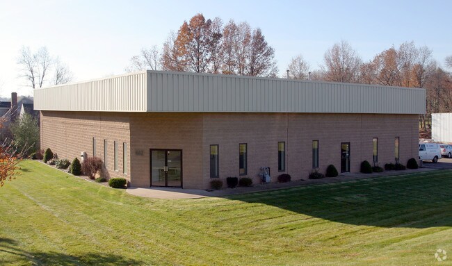
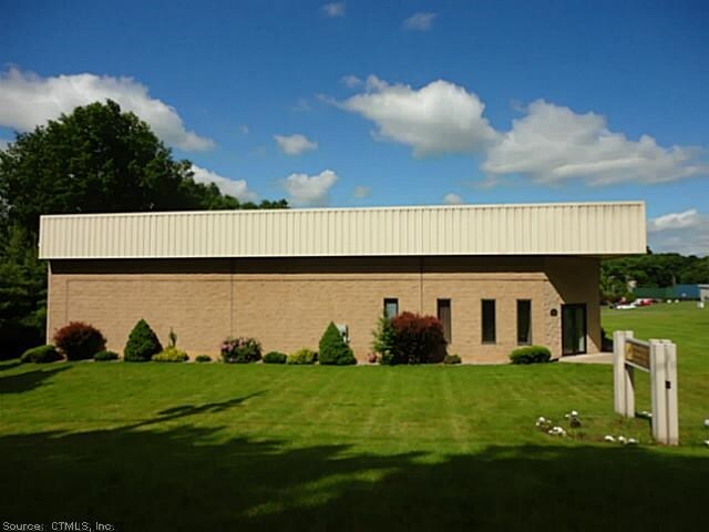
612 Four Rod Rd
BERL-000153-000090-000006-000002
Capitol
Manufacturinglight
Connecticut
PI-2
6-2
B and X Area of moderate flood hazard, usually the area between the limits of the 100-year and 500-year floods.
1.15 AC
2025
Berlin
2025
Hartford
400102
Hartford-West Hartford-East Hartford, CT
7,950 SF
NEARBY LISTINGS FOR SALE OR LEASE
DEMOGRAPHICS near 612 Four Rod Rd
1 mile
3 mile
5 mile
2025 Total Population
4,269
28,449
128,939
2030 Population
4,308
28,685
130,327
Pop Growth 2025-2030
+ 0.91%
+ 0.83%
+ 1.08%
Average Age
44
43
41
2025 Total Households
1,701
11,236
52,698
HH Growth 2025-2030
+ 0.82%
+ 0.87%
+ 1.10%
Median Household Inc
$106,250
$97,140
$76,850
Avg Household Size
2.50
2.50
2.40
2025 Avg HH Vehicles
2.00
2.00
2.00
Median Home Value
$358,880
$353,255
$311,815
Median Year Built
1970
1967
1967
Nearby Places
Map Layers
Map Styles
 Street
 Aerial
Layers
 Traffic
 Biking
Places
Listings with unknown addresses are not visible on the map
- Restaurants
- Banks
- Shops
- Fitness
- Groceries
PUBLIC TRANSPORTATION
COMMUTER RAIL
Drive
Walk
Distance
6 min
2.3 mi
Drive
Walk
Distance
6 min
2.3 mi
AIRPORT
Tweed/New Haven
Drive
Walk
Distance
Tweed/New Haven
43 min
30.1 mi
Bradley International
Drive
Walk
Distance
Bradley International
50 min
30.5 mi
Freight Ports
Port of New Haven
Drive
Walk
Distance
Port of New Haven
39 min
27.8 mi
Nearby Properties
Address
Land Use
TOTAL SIZE
Lot Size
Zoning
Address
Land Use
TOTAL SIZE
Lot Size
Zoning
241,225 SF
25.64 AC
R-11
Address
Land Use
TOTAL SIZE
Lot Size
Zoning
33.36 AC
T
Address
Land Use
TOTAL SIZE
Lot Size
Zoning
129,626 SF
22.36 AC
IT
Address
Land Use
TOTAL SIZE
Lot Size
Zoning
38,860 SF
38.47 AC
PS-B
Address
Land Use
TOTAL SIZE
Lot Size
Zoning
185,902 SF
101.89 AC
GI-2
Address
Land Use
TOTAL SIZE
Lot Size
Zoning
76,510 SF
10 AC
R-11
Address
Land Use
TOTAL SIZE
Lot Size
Zoning
18.53 AC
BTD
Address
Land Use
TOTAL SIZE
Lot Size
Zoning
91,663 SF
22.20 AC
R-21
Address
Land Use
TOTAL SIZE
Lot Size
Zoning
44,084 SF
1.36 AC
T
Address
Land Use
TOTAL SIZE
Lot Size
Zoning
197,680 SF
26.91 AC
IT
Address
Land Use
TOTAL SIZE
Lot Size
Zoning
25.10 AC
R-15
Address
Land Use
TOTAL SIZE
Lot Size
Zoning
13.02 AC
HB
Address
Land Use
TOTAL SIZE
Lot Size
Zoning
67,050 SF
20.36 AC
R-15
Address
Land Use
TOTAL SIZE
Lot Size
Zoning
61,435 SF
25.96 AC
R-15
Address
Land Use
TOTAL SIZE
Lot Size
Zoning
228,928 SF
16.24 AC
IT
Address
Land Use
TOTAL SIZE
Lot Size
Zoning
156,397 SF
28 AC
HB
Address
Land Use
TOTAL SIZE
Lot Size
Zoning
38,096 SF
8.26 AC
PS-A
Address
Land Use
TOTAL SIZE
Lot Size
Zoning
196,455 SF
7.02 AC
I2
Address
Land Use
TOTAL SIZE
Lot Size
Zoning
61,047 SF
9.12 AC
CCD-2
Address
Land Use
TOTAL SIZE
Lot Size
Zoning
236,666 SF
32.60 AC
R-21
Address
Land Use
TOTAL SIZE
Lot Size
Zoning
48,668 SF
6.96 AC
R-11
Address
Land Use
TOTAL SIZE
Lot Size
Zoning
66 AC
GI-2
Address
Land Use
TOTAL SIZE
Lot Size
Zoning
63,199 SF
16.80 AC
PI
Address
Land Use
TOTAL SIZE
Lot Size
Zoning
11,368 SF
3.53 AC
R-11
Address
Land Use
TOTAL SIZE
Lot Size
Zoning
100,200 SF
5.63 AC
PI
Address
Land Use
TOTAL SIZE
Lot Size
Zoning
91,005 SF
11.04 AC
IND
Address
Land Use
TOTAL SIZE
Lot Size
Zoning
53,082 SF
8.20 AC
PD
Address
Land Use
TOTAL SIZE
Lot Size
Zoning
9,730 SF
3.80 AC
POR
Address
Land Use
TOTAL SIZE
Lot Size
Zoning
56,878 SF
5.32 AC
A3
Address
Land Use
TOTAL SIZE
Lot Size
Zoning
126,727 SF
45.42 AC
PI
The World's #1 Commercial Real Estate Marketplace
Connect with us
© 2026 CoStar Group
The information above has been obtained from sources believed reliable. While we do not doubt its accuracy we have not verified it and make no guarantee, warranty or representation about it. It is your responsibility to independently confirm its accuracy and completeness. Any projections, opinions, assumptions, or estimates used are for example only and do not represent the current or future performance of the property. The value of this transaction to you depends on tax and other factors which should be evaluated by your tax, financial, and legal advisors. You and your advisors should conduct a careful, independent investigation of the property to determine to your satisfaction the suitability of the property for your needs.