Property Record
612 N Main St, Phoenix, OR 97535
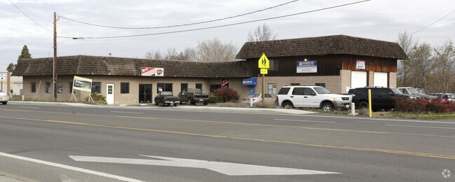

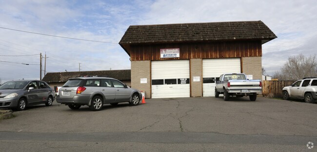

Property Detail
612 N Main St
10009707
Jackson
Commercialbuilding
Oregon
C-H
31-33
B and X Area of moderate flood hazard, usually the area between the limits of the 100-year and 500-year floods.
0.79 AC
2025
Medford/Grants Pass
2026
Other Market Areas
001601
Medford, OR
6,400 SF
NEARBY LISTINGS FOR SALE OR LEASE
DEMOGRAPHICS near 612 N Main St
1 mile
3 mile
5 mile
2025 Total Population
6,118
20,649
73,996
2030 Population
5,841
20,071
72,404
Pop Growth 2025-2030
(4.53%)
(2.80%)
(2.15%)
Average Age
44
46
43
2025 Total Households
2,687
9,308
30,308
HH Growth 2025-2030
(4.88%)
(2.95%)
(2.31%)
Median Household Inc
$62,388
$64,340
$69,704
Avg Household Size
2.20
2.10
2.40
2025 Avg HH Vehicles
2.00
2.00
2.00
Median Home Value
$256,862
$411,047
$436,164
Median Year Built
1978
1987
1981
Nearby Places
Map Layers
Map Styles
 Street
 Aerial
Layers
 Traffic
 Biking
Places
Listings with unknown addresses are not visible on the map
- Restaurants
- Banks
- Shops
- Fitness
- Groceries
PUBLIC TRANSPORTATION
AIRPORT
Rogue Valley International - Medford
Drive
Walk
Distance
Rogue Valley International - Medford
13 min
8.1 mi
Freight Ports
Port of Coos Bay, OR
Drive
Walk
Distance
Port of Coos Bay, OR
222 min
169.4 mi
SALE & LEASE HISTORY
LISTING DATE
SALE/LEASE

Feb 02, 2018
For Lease
Nearby Properties
Address
Land Use
TOTAL SIZE
Lot Size
Zoning
Address
Land Use
TOTAL SIZE
Lot Size
Zoning
674,760 SF
104.26 AC
SFR-4
Address
Land Use
TOTAL SIZE
Lot Size
Zoning
762,720 SF
16.25 AC
C-S/P
Address
Land Use
TOTAL SIZE
Lot Size
Zoning
124.05 AC
C-R
Address
Land Use
TOTAL SIZE
Lot Size
Zoning
Address
Land Use
TOTAL SIZE
Lot Size
Zoning
30.50 AC
SFR-4
Address
Land Use
TOTAL SIZE
Lot Size
Zoning
81.70 AC
LI
Address
Land Use
TOTAL SIZE
Lot Size
Zoning
11,850 SF
3.19 AC
RS-7
Address
Land Use
TOTAL SIZE
Lot Size
Zoning
12,544 SF
16.70 AC
C-R
Address
Land Use
TOTAL SIZE
Lot Size
Zoning
31,338 SF
4.41 AC
C-R
Address
Land Use
TOTAL SIZE
Lot Size
Zoning
212,477 SF
13.74 AC
I-L
Address
Land Use
TOTAL SIZE
Lot Size
Zoning
5.22 AC
MFR-30
Address
Land Use
TOTAL SIZE
Lot Size
Zoning
12.55 AC
RM-22
Address
Land Use
TOTAL SIZE
Lot Size
Zoning
77,365 SF
3.25 AC
SFR-10
Address
Land Use
TOTAL SIZE
Lot Size
Zoning
9,216 SF
1.66 AC
C-R
Address
Land Use
TOTAL SIZE
Lot Size
Zoning
106,312 SF
3.87 AC
SFR-10
Address
Land Use
TOTAL SIZE
Lot Size
Zoning
12,944 SF
21.34 AC
SFR-4
Address
Land Use
TOTAL SIZE
Lot Size
Zoning
50,943 SF
0.18 AC
SFR-00
Address
Land Use
TOTAL SIZE
Lot Size
Zoning
130,599 SF
9.43 AC
C-H
Address
Land Use
TOTAL SIZE
Lot Size
Zoning
92,000 SF
3.39 AC
MFR-30
Address
Land Use
TOTAL SIZE
Lot Size
Zoning
50,853 SF
5.24 AC
C-R
Address
Land Use
TOTAL SIZE
Lot Size
Zoning
37,997 SF
14.47 AC
SFR-4
Address
Land Use
TOTAL SIZE
Lot Size
Zoning
53,886 SF
2.38 AC
C-R
Address
Land Use
TOTAL SIZE
Lot Size
Zoning
81.69 AC
LI
Address
Land Use
TOTAL SIZE
Lot Size
Zoning
244 SF
32.31 AC
UR-10
Address
Land Use
TOTAL SIZE
Lot Size
Zoning
97,016 SF
5.11 AC
MFR-20
Address
Land Use
TOTAL SIZE
Lot Size
Zoning
1,660 SF
4.65 AC
C-H
Address
Land Use
TOTAL SIZE
Lot Size
Zoning
22,504 SF
1.88 AC
C-S/P
Address
Land Use
TOTAL SIZE
Lot Size
Zoning
5.46 AC
RS-7
Address
Land Use
TOTAL SIZE
Lot Size
Zoning
38,400 SF
2.03 AC
C-S/P
Address
Land Use
TOTAL SIZE
Lot Size
Zoning
9,052 SF
6.42 AC
SFR-00
The World's #1 Commercial Real Estate Marketplace
Connect with us
© 2026 CoStar Group
The information above has been obtained from sources believed reliable. While we do not doubt its accuracy we have not verified it and make no guarantee, warranty or representation about it. It is your responsibility to independently confirm its accuracy and completeness. Any projections, opinions, assumptions, or estimates used are for example only and do not represent the current or future performance of the property. The value of this transaction to you depends on tax and other factors which should be evaluated by your tax, financial, and legal advisors. You and your advisors should conduct a careful, independent investigation of the property to determine to your satisfaction the suitability of the property for your needs.