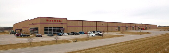
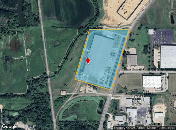
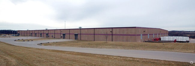
Property Record
612 N Stevenson St, Deforest, WI 53532
NEARBY LISTINGS FOR SALE OR LEASE
Property Detail
612 N Stevenson St
Madison, WI
LOT 1 CSM 9468 CS54/56&58-10/12/99 DESCR AS SEC 8-9-10 PRT NW1/4SW1/4 & PRT NE1/ 4SW1/4 (19.561 ACRES) SUBJ TO ESMT IN DOC #3182403 & #5413544
0910-083-8060-1
Dane
Industrialgeneral
Wisconsin
AE
1
55021C0565F
19.56 AC
2024
Outlying Dane East
2024
Milwaukee/Madison
013301
DEMOGRAPHICS near 612 N Stevenson St
1 Mile
3 Mile
5 Mile
2024 Total Population
3,834
14,901
22,062
2029 Population
3,923
15,518
22,987
Pop Growth 2024-2029
+ 2.32%
+ 4.14%
+ 4.19%
Average Age
39
39
39
2024 Total Households
1,482
5,647
8,301
HH Growth 2024-2029
+ 2.36%
+ 4.21%
+ 4.26%
Median Household Inc
$82,722
$91,313
$98,786
Avg Household Size
2.60
2.60
2.60
2024 Avg HH Vehicles
2.00
2.00
2.00
Median Home Value
$278,444
$310,739
$336,903
Median Year Built
1982
1990
1990
Nearby Places
Map Layers
Map Styles
 Street
 Aerial
- Restaurants
- Banks
- Shops
- Fitness
- Groceries
PUBLIC TRANSPORTATION
AIRPORT
Dane County Regional/Truax Field
DRIVE
WALK
Distance
Dane County Regional/Truax Field
18 min
11.6 mi
Freight Ports
Port Milwaukee
DRIVE
WALK
Distance
Port Milwaukee
100 min
85.6 mi
Nearby Properties
Address
Land Use
TOTAL SIZE
Lot Size
Zoning
Address
Land Use
TOTAL SIZE
Lot Size
Zoning
26.50 AC
Address
Land Use
TOTAL SIZE
Lot Size
Zoning
3.77 AC
Address
Land Use
TOTAL SIZE
Lot Size
Zoning
15.91 AC
Address
Land Use
TOTAL SIZE
Lot Size
Zoning
21.88 AC
Address
Land Use
TOTAL SIZE
Lot Size
Zoning
13.40 AC
Address
Land Use
TOTAL SIZE
Lot Size
Zoning
11.62 AC
Address
Land Use
TOTAL SIZE
Lot Size
Zoning
9.10 AC
Address
Land Use
TOTAL SIZE
Lot Size
Zoning
14.75 AC
Address
Land Use
TOTAL SIZE
Lot Size
Zoning
3.72 AC
R-4
Address
Land Use
TOTAL SIZE
Lot Size
Zoning
38.60 AC
Address
Land Use
TOTAL SIZE
Lot Size
Zoning
11.08 AC
Address
Land Use
TOTAL SIZE
Lot Size
Zoning
1.87 AC
R-4
Address
Land Use
TOTAL SIZE
Lot Size
Zoning
6.31 AC
Address
Land Use
TOTAL SIZE
Lot Size
Zoning
17.93 AC
ETZ
Address
Land Use
TOTAL SIZE
Lot Size
Zoning
4.91 AC
Address
Land Use
TOTAL SIZE
Lot Size
Zoning
Address
Land Use
TOTAL SIZE
Lot Size
Zoning
0.60 AC
Address
Land Use
TOTAL SIZE
Lot Size
Zoning
6.15 AC
Address
Land Use
TOTAL SIZE
Lot Size
Zoning
4.10 AC
Address
Land Use
TOTAL SIZE
Lot Size
Zoning
6.56 AC
Address
Land Use
TOTAL SIZE
Lot Size
Zoning
Address
Land Use
TOTAL SIZE
Lot Size
Zoning
9.38 AC
Address
Land Use
TOTAL SIZE
Lot Size
Zoning
1.32 AC
Address
Land Use
TOTAL SIZE
Lot Size
Zoning
30.80 AC
Address
Land Use
TOTAL SIZE
Lot Size
Zoning
3.25 AC
ETZ
Address
Land Use
TOTAL SIZE
Lot Size
Zoning
Address
Land Use
TOTAL SIZE
Lot Size
Zoning
2.19 AC
The World's #1 Commercial Real Estate Marketplace
Connect with us
© 2026 CoStar Group
The information above has been obtained from sources believed reliable. While we do not doubt its accuracy we have not verified it and make no guarantee, warranty or representation about it. It is your responsibility to independently confirm its accuracy and completeness. Any projections, opinions, assumptions, or estimates used are for example only and do not represent the current or future performance of the property. The value of this transaction to you depends on tax and other factors which should be evaluated by your tax, financial, and legal advisors. You and your advisors should conduct a careful, independent investigation of the property to determine to your satisfaction the suitability of the property for your needs.