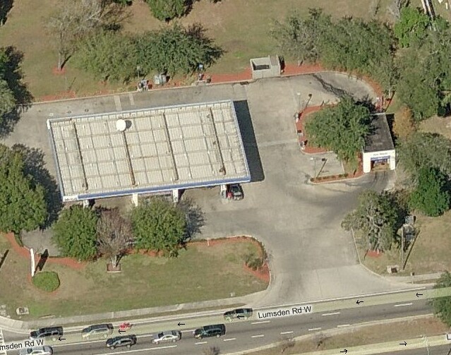
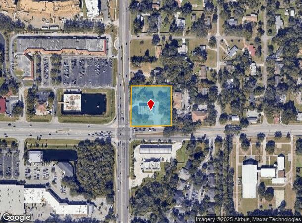
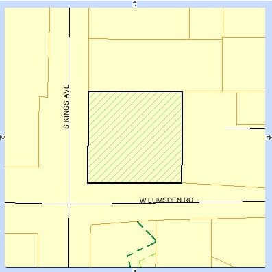
Property Record
612 W Lumsden Rd, Brandon, FL 33511
NEARBY LISTINGS FOR SALE OR LEASE
Property Detail
612 W Lumsden Rd
Tampa-St. Petersburg-Clearwater, FL
Unplatted
U-27-29-20-ZZZ-000002-67250.0
SW 1/4 OF SW 1/4 OF SW 1/4 OF SE 1/4 LESS RDS
Servicestationmarket
Hillsborough
X
Florida
12057C0391H
67250
2024
1.80 AC
2024
East Tampa
013311
Tampa/St Petersburg
1,716 SF
DEMOGRAPHICS near 612 W Lumsden Rd
1 Mile
3 Mile
5 Mile
2024 Total Population
11,193
103,545
239,817
2029 Population
12,269
112,825
261,396
Pop Growth 2024-2029
+ 9.61%
+ 8.96%
+ 9.00%
Average Age
41
39
39
2024 Total Households
4,488
40,552
90,844
HH Growth 2024-2029
+ 9.85%
+ 9.27%
+ 9.38%
Median Household Inc
$64,618
$67,052
$70,737
Avg Household Size
2.40
2.50
2.60
2024 Avg HH Vehicles
2.00
2.00
2.00
Median Home Value
$272,872
$274,440
$273,793
Median Year Built
1987
1991
1994
Nearby Places
Map Layers
Map Styles
 Street
 Aerial
- Restaurants
- Banks
- Shops
- Fitness
- Groceries
PUBLIC TRANSPORTATION
AIRPORT
Tampa International
DRIVE
WALK
Distance
Tampa International
31 min
20.2 mi
St Pete-Clearwater International
DRIVE
WALK
Distance
St Pete-Clearwater International
48 min
29.5 mi
Freight Ports
Port of Tampa Bay
DRIVE
WALK
Distance
Port of Tampa Bay
19 min
10.3 mi
Nearby Properties
Address
Land Use
TOTAL SIZE
Lot Size
Zoning
Address
Land Use
TOTAL SIZE
Lot Size
Zoning
733,263 SF
72.88 AC
PD
Address
Land Use
TOTAL SIZE
Lot Size
Zoning
868,482 SF
60.83 AC
PD
Address
Land Use
TOTAL SIZE
Lot Size
Zoning
589,526 SF
18.06 AC
PD
Address
Land Use
TOTAL SIZE
Lot Size
Zoning
574,867 SF
31.07 AC
PD
Address
Land Use
TOTAL SIZE
Lot Size
Zoning
606,551 SF
18.23 AC
PD
Address
Land Use
TOTAL SIZE
Lot Size
Zoning
501,085 SF
41.18 AC
PD
Address
Land Use
TOTAL SIZE
Lot Size
Zoning
349,931 SF
19.43 AC
PD
Address
Land Use
TOTAL SIZE
Lot Size
Zoning
379,023 SF
22.16 AC
PD
Address
Land Use
TOTAL SIZE
Lot Size
Zoning
317,413 SF
14.60 AC
PD
Address
Land Use
TOTAL SIZE
Lot Size
Zoning
378,206 SF
20.48 AC
PD
Address
Land Use
TOTAL SIZE
Lot Size
Zoning
443,914 SF
80.27 AC
IPD-3
Address
Land Use
TOTAL SIZE
Lot Size
Zoning
427,830 SF
23.95 AC
PD
Address
Land Use
TOTAL SIZE
Lot Size
Zoning
358,987 SF
49.16 AC
PD
Address
Land Use
TOTAL SIZE
Lot Size
Zoning
402,388 SF
34.49 AC
PD
Address
Land Use
TOTAL SIZE
Lot Size
Zoning
339,482 SF
19.15 AC
PD
Address
Land Use
TOTAL SIZE
Lot Size
Zoning
426,236 SF
21.09 AC
PD
Address
Land Use
TOTAL SIZE
Lot Size
Zoning
378,173 SF
20.06 AC
PD
Address
Land Use
TOTAL SIZE
Lot Size
Zoning
328,279 SF
15.31 AC
PD
Address
Land Use
TOTAL SIZE
Lot Size
Zoning
391,668 SF
27.43 AC
PD
Address
Land Use
TOTAL SIZE
Lot Size
Zoning
273,935 SF
15.42 AC
PD
Address
Land Use
TOTAL SIZE
Lot Size
Zoning
340,192 SF
18.70 AC
PD
Address
Land Use
TOTAL SIZE
Lot Size
Zoning
286,084 SF
15.67 AC
PD
Address
Land Use
TOTAL SIZE
Lot Size
Zoning
283,777 SF
36.66 AC
PD
Address
Land Use
TOTAL SIZE
Lot Size
Zoning
240,305 SF
20.01 AC
RMC-20
Address
Land Use
TOTAL SIZE
Lot Size
Zoning
135,692 SF
11.03 AC
PD
Address
Land Use
TOTAL SIZE
Lot Size
Zoning
182,314 SF
7.59 AC
PD
Address
Land Use
TOTAL SIZE
Lot Size
Zoning
178,972 SF
16.28 AC
PD
Address
Land Use
TOTAL SIZE
Lot Size
Zoning
181,587 SF
17.57 AC
PD
Address
Land Use
TOTAL SIZE
Lot Size
Zoning
237,943 SF
8.25 AC
PD
Address
Land Use
TOTAL SIZE
Lot Size
Zoning
197,357 SF
14.90 AC
PD
The World's #1 Commercial Real Estate Marketplace
Connect with us
© 2025 CoStar Group
The information above has been obtained from sources believed reliable. While we do not doubt its accuracy we have not verified it and make no guarantee, warranty or representation about it. It is your responsibility to independently confirm its accuracy and completeness. Any projections, opinions, assumptions, or estimates used are for example only and do not represent the current or future performance of the property. The value of this transaction to you depends on tax and other factors which should be evaluated by your tax, financial, and legal advisors. You and your advisors should conduct a careful, independent investigation of the property to determine to your satisfaction the suitability of the property for your needs.