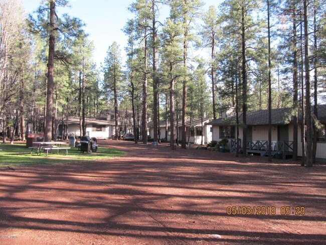
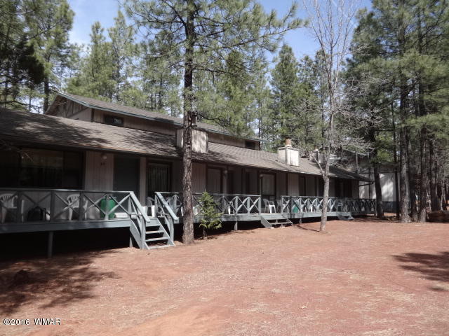
Property Record
6126 Buck Springs Rd, Pinetop, AZ 85935


NEARBY LISTINGS FOR SALE OR LEASE
-
-
View all Pinetop listings for sale on LoopNet.com
Property Detail
6126 Buck Springs Rd
411-40-018
SECTIONS 2 & 11,T8N,R23E: BEG NW COR SEC 11;TH N89DG53'30 E 2325'TH N0DG50'46 E 35.91'TPOB;TH N0DG50'46 E 875.98'; TH S85DG12'7 W741.05';TH S43DG45'48 W 247.83'; TH S46DG14'12 E 93.91';TH 207.04' ALG CURVE RT (R-550.48'); TH S24DG41'14 E 369.57';TH 1
Resorthotel
Navajo
X
Arizona
04017C4975F
19.77 AC
2024
Arizona Northeast & Holbrook Area
2026
Other Market Areas
964902
Show Low, AZ
18,694 SF
DEMOGRAPHICS near 6126 Buck Springs Rd
1 Mile
3 Mile
5 Mile
2024 Total Population
1,863
6,517
9,274
2029 Population
2,118
7,149
10,103
Pop Growth 2024-2029
+ 13.69%
+ 9.70%
+ 8.94%
Average Age
54
45
45
2024 Total Households
859
2,544
3,640
HH Growth 2024-2029
+ 13.39%
+ 10.57%
+ 9.48%
Median Household Inc
$89,549
$71,067
$67,111
Avg Household Size
2.10
2.50
2.50
2024 Avg HH Vehicles
2.00
2.00
2.00
Median Home Value
$260,915
$250,561
$253,546
Median Year Built
1993
1991
1990
Nearby Places
Map Layers
Map Styles
 Street
 Aerial
- Restaurants
- Banks
- Shops
- Fitness
- Groceries
SALE & LEASE HISTORY
LISTING DATE
SALE/LEASE

Nov 27, 2019
For Sale
Nearby Properties
Address
Land Use
TOTAL SIZE
Lot Size
Zoning
Address
Land Use
TOTAL SIZE
Lot Size
Zoning
320 AC
Address
Land Use
TOTAL SIZE
Lot Size
Zoning
38,549 SF
2.40 AC
MUNICIPAL
Address
Land Use
TOTAL SIZE
Lot Size
Zoning
68,009 SF
5.41 AC
C-R
Address
Land Use
TOTAL SIZE
Lot Size
Zoning
21,831 SF
45.94 AC
R1-10
Address
Land Use
TOTAL SIZE
Lot Size
Zoning
16,458 SF
3.20 AC
MUNICIPAL
Address
Land Use
TOTAL SIZE
Lot Size
Zoning
28,195 SF
6.62 AC
R1-10
Address
Land Use
TOTAL SIZE
Lot Size
Zoning
12,387 SF
1.47 AC
MUNICIPAL
Address
Land Use
TOTAL SIZE
Lot Size
Zoning
9,078 SF
2.56 AC
MUNICIPAL
Address
Land Use
TOTAL SIZE
Lot Size
Zoning
10,426 SF
0.80 AC
MUNICIPAL
Address
Land Use
TOTAL SIZE
Lot Size
Zoning
11,152 SF
1 AC
SD
Address
Land Use
TOTAL SIZE
Lot Size
Zoning
10,303 SF
2.60 AC
MUNICIPAL
Address
Land Use
TOTAL SIZE
Lot Size
Zoning
9,186 SF
1.09 AC
MUNICIPAL
Address
Land Use
TOTAL SIZE
Lot Size
Zoning
3,897 SF
1.29 AC
MUNICIPAL
Address
Land Use
TOTAL SIZE
Lot Size
Zoning
17.09 AC
R1-10
Address
Land Use
TOTAL SIZE
Lot Size
Zoning
84.46 AC
A-GENERAL
Address
Land Use
TOTAL SIZE
Lot Size
Zoning
5,456 SF
5 AC
MUNICIPAL
Address
Land Use
TOTAL SIZE
Lot Size
Zoning
17,140 SF
0.86 AC
MUNICIPAL
Address
Land Use
TOTAL SIZE
Lot Size
Zoning
4,714 SF
0.97 AC
MUNICIPAL
Address
Land Use
TOTAL SIZE
Lot Size
Zoning
8,034 SF
1.95 AC
MUNICIPAL
Address
Land Use
TOTAL SIZE
Lot Size
Zoning
11,109 SF
0.50 AC
MUNICIPAL
Address
Land Use
TOTAL SIZE
Lot Size
Zoning
3,206 SF
0.39 AC
R1-10
Address
Land Use
TOTAL SIZE
Lot Size
Zoning
3,420 SF
0.70 AC
MUNICIPAL
Address
Land Use
TOTAL SIZE
Lot Size
Zoning
3,050 SF
0.33 AC
R1-10
Address
Land Use
TOTAL SIZE
Lot Size
Zoning
7.98 AC
MUNICIPAL
Address
Land Use
TOTAL SIZE
Lot Size
Zoning
11,162 SF
0.25 AC
MUNICIPAL
Address
Land Use
TOTAL SIZE
Lot Size
Zoning
11,448 SF
3.37 AC
R1-10
Address
Land Use
TOTAL SIZE
Lot Size
Zoning
4,594 SF
0.16 AC
MUNICIPAL
The World's #1 Commercial Real Estate Marketplace
Connect with us
© 2026 CoStar Group
The information above has been obtained from sources believed reliable. While we do not doubt its accuracy we have not verified it and make no guarantee, warranty or representation about it. It is your responsibility to independently confirm its accuracy and completeness. Any projections, opinions, assumptions, or estimates used are for example only and do not represent the current or future performance of the property. The value of this transaction to you depends on tax and other factors which should be evaluated by your tax, financial, and legal advisors. You and your advisors should conduct a careful, independent investigation of the property to determine to your satisfaction the suitability of the property for your needs.