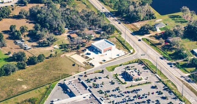
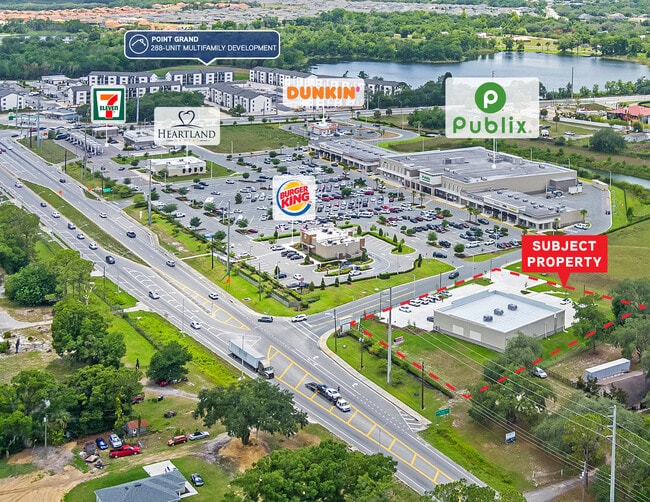
Property Record
6127 Us Highway 17 92 N, Davenport, FL 33896


NEARBY LISTINGS FOR SALE OR LEASE
-
-
No Photo
-
View all Davenport listings for sale on LoopNet.com
Property Detail
6127 Us Highway 17 92 N
Lakeland-Winter Haven, FL
Loughman Crossing
27-26-12-703508-000060
LOUGHMAN CROSSING PB 171 PGS 48-50 LOT 6
Restaurantdrivein
Polk
X
Florida
12105C0235H
6
2024
1.17 AC
2025
Polk County
012502
Tampa/St Petersburg
3,410 SF
DEMOGRAPHICS near 6127 Us Highway 17 92 N
1 Mile
3 Mile
5 Mile
2024 Total Population
5,054
27,456
64,130
2029 Population
6,273
34,213
79,670
Pop Growth 2024-2029
+ 24.12%
+ 24.61%
+ 24.23%
Average Age
36
37
38
2024 Total Households
1,659
9,528
23,261
HH Growth 2024-2029
+ 24.05%
+ 24.54%
+ 24.31%
Median Household Inc
$66,406
$60,824
$67,104
Avg Household Size
3.00
2.80
2.70
2024 Avg HH Vehicles
2.00
2.00
2.00
Median Home Value
$279,067
$287,688
$287,594
Median Year Built
2006
2006
2007
Nearby Places
Map Layers
Map Styles
 Street
 Aerial
- Restaurants
- Banks
- Shops
- Fitness
- Groceries
PUBLIC TRANSPORTATION
COMMUTER RAIL
Poinciana (SunRail - Florida Department of Transportation)
DRIVE
WALK
Distance
Poinciana (SunRail - Florida Department of Transportation)
9 min
5.7 mi
AIRPORT
Orlando International
DRIVE
WALK
Distance
Orlando International
43 min
30.5 mi
Freight Ports
Port of Tampa Bay
DRIVE
WALK
Distance
Port of Tampa Bay
78 min
64.3 mi
SALE & LEASE HISTORY
LISTING DATE
SALE/LEASE

Oct 30, 2023
For Sale
Nearby Properties
Address
Land Use
TOTAL SIZE
Lot Size
Zoning
Address
Land Use
TOTAL SIZE
Lot Size
Zoning
417,544 SF
62.60 AC
Address
Land Use
TOTAL SIZE
Lot Size
Zoning
434,491 SF
27.48 AC
Address
Land Use
TOTAL SIZE
Lot Size
Zoning
425,752 SF
19.52 AC
Address
Land Use
TOTAL SIZE
Lot Size
Zoning
302,226 SF
135.83 AC
Address
Land Use
TOTAL SIZE
Lot Size
Zoning
335,536 SF
11.97 AC
Address
Land Use
TOTAL SIZE
Lot Size
Zoning
329,700 SF
12.09 AC
Address
Land Use
TOTAL SIZE
Lot Size
Zoning
352,892 SF
19.23 AC
Address
Land Use
TOTAL SIZE
Lot Size
Zoning
336,042 SF
20.77 AC
Address
Land Use
TOTAL SIZE
Lot Size
Zoning
216,296 SF
16.37 AC
Address
Land Use
TOTAL SIZE
Lot Size
Zoning
338,315 SF
59.58 AC
Address
Land Use
TOTAL SIZE
Lot Size
Zoning
41,812 SF
162.70 AC
OAC
Address
Land Use
TOTAL SIZE
Lot Size
Zoning
148,436 SF
10.27 AC
Address
Land Use
TOTAL SIZE
Lot Size
Zoning
87,848 SF
14.44 AC
OAC
Address
Land Use
TOTAL SIZE
Lot Size
Zoning
98,712 SF
11.90 AC
Address
Land Use
TOTAL SIZE
Lot Size
Zoning
74,571 SF
9.98 AC
Address
Land Use
TOTAL SIZE
Lot Size
Zoning
22,458 SF
45.23 AC
OAC
Address
Land Use
TOTAL SIZE
Lot Size
Zoning
23,487 SF
2.54 AC
OPD
Address
Land Use
TOTAL SIZE
Lot Size
Zoning
88,912 SF
24.99 AC
RC
Address
Land Use
TOTAL SIZE
Lot Size
Zoning
28.18 AC
Address
Land Use
TOTAL SIZE
Lot Size
Zoning
112.98 AC
OPUD
Address
Land Use
TOTAL SIZE
Lot Size
Zoning
43,567 SF
29.99 AC
OPUD
Address
Land Use
TOTAL SIZE
Lot Size
Zoning
13,786 SF
4.99 AC
Address
Land Use
TOTAL SIZE
Lot Size
Zoning
Address
Land Use
TOTAL SIZE
Lot Size
Zoning
32,408 SF
592.27 AC
OAC
Address
Land Use
TOTAL SIZE
Lot Size
Zoning
14,908 SF
1.45 AC
OPD
Address
Land Use
TOTAL SIZE
Lot Size
Zoning
37,719 SF
24.78 AC
OPD
Address
Land Use
TOTAL SIZE
Lot Size
Zoning
14,660 SF
5.14 AC
Address
Land Use
TOTAL SIZE
Lot Size
Zoning
7.10 AC
RC
Address
Land Use
TOTAL SIZE
Lot Size
Zoning
19.70 AC
Address
Land Use
TOTAL SIZE
Lot Size
Zoning
3,050 SF
1.16 AC
OPD
The World's #1 Commercial Real Estate Marketplace
Connect with us
© 2025 CoStar Group
The information above has been obtained from sources believed reliable. While we do not doubt its accuracy we have not verified it and make no guarantee, warranty or representation about it. It is your responsibility to independently confirm its accuracy and completeness. Any projections, opinions, assumptions, or estimates used are for example only and do not represent the current or future performance of the property. The value of this transaction to you depends on tax and other factors which should be evaluated by your tax, financial, and legal advisors. You and your advisors should conduct a careful, independent investigation of the property to determine to your satisfaction the suitability of the property for your needs.