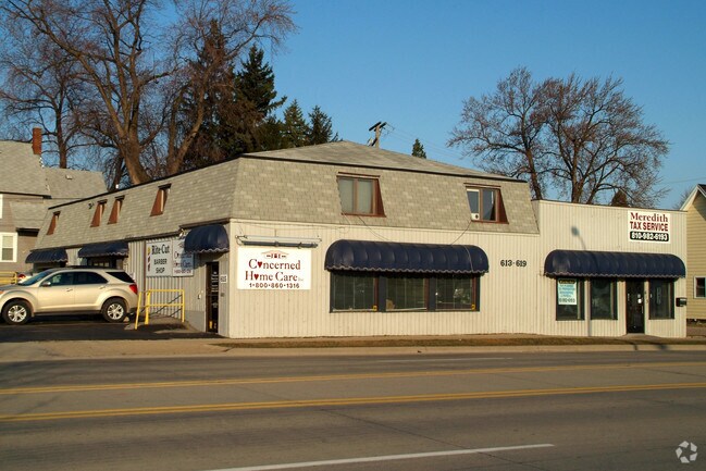
Property Record
619 S 10Th St, Saint Clair, MI 48079

NEARBY LISTINGS FOR SALE OR LEASE
Property Detail
619 S 10Th St
Detroit-Warren-Dearborn, MI
Assessors
07-094-0015-000
St. Clair
Sfr
Michigan
X
0.23 AC
26147C0453D
St Clair & Lapeer Counties
1,155 SF
Detroit
DEMOGRAPHICS near 619 S 10Th St
1 Mile
3 Mile
5 Mile
2024 Total Population
12,266
33,808
56,444
2029 Population
12,366
33,843
56,393
Pop Growth 2024-2029
+ 0.82%
+ 0.10%
(0.09%)
Average Age
39
40
41
2024 Total Households
5,128
14,041
23,447
HH Growth 2024-2029
+ 0.92%
+ 0.05%
(0.15%)
Median Household Inc
$38,805
$48,231
$53,449
Avg Household Size
2.30
2.30
2.30
2024 Avg HH Vehicles
1.00
2.00
2.00
Median Home Value
$82,042
$130,473
$153,803
Median Year Built
1950
1957
1968
Nearby Places
Map Layers
Map Styles
 Street
 Aerial
- Restaurants
- Banks
- Shops
- Fitness
- Groceries
SALE & LEASE HISTORY
LISTING DATE
SALE/LEASE

Jun 16, 2017
For Lease
Nearby Properties
Address
Land Use
TOTAL SIZE
Lot Size
Zoning
Address
Land Use
TOTAL SIZE
Lot Size
Zoning
720,000 SF
Address
Land Use
TOTAL SIZE
Lot Size
Zoning
369,800 SF
Address
Land Use
TOTAL SIZE
Lot Size
Zoning
98,736 SF
8.49 AC
RM
Address
Land Use
TOTAL SIZE
Lot Size
Zoning
112,914 SF
9.89 AC
R-3 MLTPLE
Address
Land Use
TOTAL SIZE
Lot Size
Zoning
84,198 SF
8.95 AC
C-2 GENERA
Address
Land Use
TOTAL SIZE
Lot Size
Zoning
46,800 SF
Address
Land Use
TOTAL SIZE
Lot Size
Zoning
133,345 SF
11.69 AC
M-1 LIGHT
Address
Land Use
TOTAL SIZE
Lot Size
Zoning
184,348 SF
17.77 AC
I-1
Address
Land Use
TOTAL SIZE
Lot Size
Zoning
579,846 SF
8.21 AC
M-2 HEAVY
Address
Land Use
TOTAL SIZE
Lot Size
Zoning
137,000 SF
11.14 AC
M-1 LIGHT
Address
Land Use
TOTAL SIZE
Lot Size
Zoning
65,924 SF
6.36 AC
MC
Address
Land Use
TOTAL SIZE
Lot Size
Zoning
112,486 SF
11.91 AC
M-1 LIGHT
Address
Land Use
TOTAL SIZE
Lot Size
Zoning
53,291 SF
Address
Land Use
TOTAL SIZE
Lot Size
Zoning
39,423 SF
64.91 AC
I-1
Address
Land Use
TOTAL SIZE
Lot Size
Zoning
30.80 AC
R-3 MLTPLE
Address
Land Use
TOTAL SIZE
Lot Size
Zoning
39,000 SF
8.46 AC
B-2
Address
Land Use
TOTAL SIZE
Lot Size
Zoning
9.60 AC
R-1 LOW DE
Address
Land Use
TOTAL SIZE
Lot Size
Zoning
54,096 SF
6.10 AC
R-1A MED D
Address
Land Use
TOTAL SIZE
Lot Size
Zoning
24,261 SF
4.42 AC
C-2 GENERA
Address
Land Use
TOTAL SIZE
Lot Size
Zoning
24,727 SF
0.90 AC
C-1 LOCAL
Address
Land Use
TOTAL SIZE
Lot Size
Zoning
11,565 SF
4.43 AC
C-2 GENERA
Address
Land Use
TOTAL SIZE
Lot Size
Zoning
66,521 SF
5.78 AC
M-1 LIGHT
Address
Land Use
TOTAL SIZE
Lot Size
Zoning
34,726 SF
6.33 AC
R-3 MLTPLE
Address
Land Use
TOTAL SIZE
Lot Size
Zoning
91.42 AC
M-1 LIGHT
Address
Land Use
TOTAL SIZE
Lot Size
Zoning
12,032 SF
3.31 AC
MC
Address
Land Use
TOTAL SIZE
Lot Size
Zoning
12,952 SF
131.83 AC
RM
Address
Land Use
TOTAL SIZE
Lot Size
Zoning
7,380 SF
1.82 AC
C-2 GENERA
Address
Land Use
TOTAL SIZE
Lot Size
Zoning
Address
Land Use
TOTAL SIZE
Lot Size
Zoning
74,400 SF
7.52 AC
M-1 LIGHT
Address
Land Use
TOTAL SIZE
Lot Size
Zoning
41,160 SF
M-1 LIGHT
The World's #1 Commercial Real Estate Marketplace
Connect with us
© 2026 CoStar Group
The information above has been obtained from sources believed reliable. While we do not doubt its accuracy we have not verified it and make no guarantee, warranty or representation about it. It is your responsibility to independently confirm its accuracy and completeness. Any projections, opinions, assumptions, or estimates used are for example only and do not represent the current or future performance of the property. The value of this transaction to you depends on tax and other factors which should be evaluated by your tax, financial, and legal advisors. You and your advisors should conduct a careful, independent investigation of the property to determine to your satisfaction the suitability of the property for your needs.