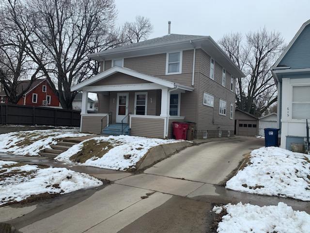
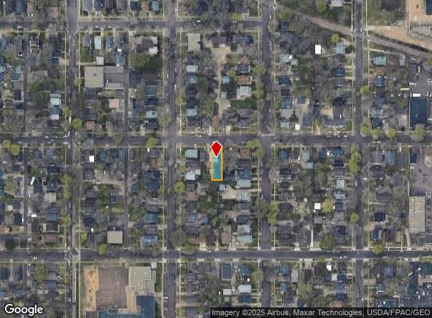
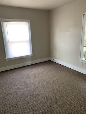
Property Record
613 W 16Th St, Sioux Falls, SD 57104
NEARBY LISTINGS FOR SALE OR LEASE
Property Detail
613 W 16Th St
Sioux Falls, SD
Lewis Addn
38732
Minnehaha
Duplex
South Dakota
X
0.12 AC
46099C0461F
Sioux Falls
1,904 SF
Other Market Areas
DEMOGRAPHICS near 613 W 16Th St
1 Mile
3 Mile
5 Mile
2024 Total Population
18,862
82,224
195,416
2029 Population
20,516
89,056
216,906
Pop Growth 2024-2029
+ 8.77%
+ 8.31%
+ 11.00%
Average Age
38
39
38
2024 Total Households
8,596
35,165
80,297
HH Growth 2024-2029
+ 9.32%
+ 8.84%
+ 11.47%
Median Household Inc
$57,125
$58,461
$71,503
Avg Household Size
2.00
2.20
2.30
2024 Avg HH Vehicles
2.00
2.00
2.00
Median Home Value
$172,908
$197,969
$254,381
Median Year Built
1950
1969
1992
Nearby Places
Map Layers
Map Styles
 Street
 Aerial
- Restaurants
- Banks
- Shops
- Fitness
- Groceries
PUBLIC TRANSPORTATION
AIRPORT
Joe Foss Field
DRIVE
WALK
Distance
Joe Foss Field
20 min
4.5 mi
Freight Ports
Port Milwaukee
DRIVE
WALK
Distance
Port Milwaukee
550 min
505.1 mi
SALE & LEASE HISTORY
LISTING DATE
SALE/LEASE

Mar 20, 2020
For Sale
Nearby Properties
Address
Land Use
TOTAL SIZE
Lot Size
Zoning
Address
Land Use
TOTAL SIZE
Lot Size
Zoning
80,415 SF
13.13 AC
Address
Land Use
TOTAL SIZE
Lot Size
Zoning
639,393 SF
53.46 AC
FP;FP
Address
Land Use
TOTAL SIZE
Lot Size
Zoning
8.90 AC
C1;NEIGHBO
Address
Land Use
TOTAL SIZE
Lot Size
Zoning
Address
Land Use
TOTAL SIZE
Lot Size
Zoning
Address
Land Use
TOTAL SIZE
Lot Size
Zoning
184,821 SF
1.83 AC
NO;SPECIAL
Address
Land Use
TOTAL SIZE
Lot Size
Zoning
7,252 SF
12.07 AC
Address
Land Use
TOTAL SIZE
Lot Size
Zoning
9.41 AC
Address
Land Use
TOTAL SIZE
Lot Size
Zoning
14,820 SF
80.57 AC
FP;FP
Address
Land Use
TOTAL SIZE
Lot Size
Zoning
360,262 SF
26 AC
Address
Land Use
TOTAL SIZE
Lot Size
Zoning
3.07 AC
FP;FP
Address
Land Use
TOTAL SIZE
Lot Size
Zoning
1.32 AC
FP;FP
Address
Land Use
TOTAL SIZE
Lot Size
Zoning
1.57 AC
C2;GENERAL
Address
Land Use
TOTAL SIZE
Lot Size
Zoning
51,004 SF
3.99 AC
Address
Land Use
TOTAL SIZE
Lot Size
Zoning
72,553 SF
0.97 AC
Address
Land Use
TOTAL SIZE
Lot Size
Zoning
1.20 AC
FP;FP
Address
Land Use
TOTAL SIZE
Lot Size
Zoning
15.89 AC
Address
Land Use
TOTAL SIZE
Lot Size
Zoning
3,254 SF
2.13 AC
Address
Land Use
TOTAL SIZE
Lot Size
Zoning
99,834 SF
6.58 AC
Address
Land Use
TOTAL SIZE
Lot Size
Zoning
7.91 AC
MUNICIPALI
Address
Land Use
TOTAL SIZE
Lot Size
Zoning
100,053 SF
8.50 AC
FP;FP
Address
Land Use
TOTAL SIZE
Lot Size
Zoning
86,019 SF
3.60 AC
NO;SPECIAL
Address
Land Use
TOTAL SIZE
Lot Size
Zoning
1.66 AC
FP;FP
Address
Land Use
TOTAL SIZE
Lot Size
Zoning
106,064 SF
35.38 AC
Address
Land Use
TOTAL SIZE
Lot Size
Zoning
173,235 SF
10 AC
Address
Land Use
TOTAL SIZE
Lot Size
Zoning
146,718 SF
1.65 AC
Address
Land Use
TOTAL SIZE
Lot Size
Zoning
2.26 AC
FP;FP
Address
Land Use
TOTAL SIZE
Lot Size
Zoning
89,935 SF
4.81 AC
Address
Land Use
TOTAL SIZE
Lot Size
Zoning
18.37 AC
Address
Land Use
TOTAL SIZE
Lot Size
Zoning
167,162 SF
17.11 AC
The World's #1 Commercial Real Estate Marketplace
Connect with us
© 2025 CoStar Group
The information above has been obtained from sources believed reliable. While we do not doubt its accuracy we have not verified it and make no guarantee, warranty or representation about it. It is your responsibility to independently confirm its accuracy and completeness. Any projections, opinions, assumptions, or estimates used are for example only and do not represent the current or future performance of the property. The value of this transaction to you depends on tax and other factors which should be evaluated by your tax, financial, and legal advisors. You and your advisors should conduct a careful, independent investigation of the property to determine to your satisfaction the suitability of the property for your needs.