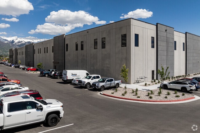
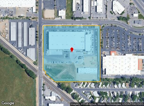
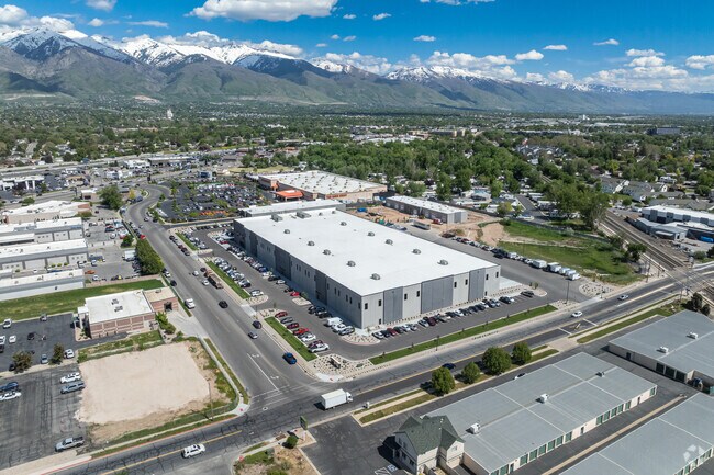
Property Record
613 W 500 St N, Layton, UT 84041
NEARBY LISTINGS FOR SALE OR LEASE
Property Detail
613 W 500 St N
Ogden-Clearfield, UT
Barlow Retail Subdivision
10-271-0005
ALL OF LOT 2, BARLOW RETAIL SUBDIVISION. CONT. 11.26400 ACRES LESS & EXCEPT: A PARCEL OF LAND IN FEE FOR THE WEBER COUNTY TO SALT LAKE COMMUTER RAIL, A UTAH TRANSIT AUTHORITY PROJECT, SD PA
Officebuilding
Davis
X
Utah
49011C0228E
2
2025
11.25 AC
2025
Davis/Weber Counties
125413
Salt Lake City
147,675 SF
DEMOGRAPHICS near 613 W 500 St N
1 Mile
3 Mile
5 Mile
2024 Total Population
9,715
99,478
184,386
2029 Population
10,237
105,739
196,054
Pop Growth 2024-2029
+ 5.37%
+ 6.29%
+ 6.33%
Average Age
34
34
34
2024 Total Households
3,226
31,442
56,294
HH Growth 2024-2029
+ 5.30%
+ 6.31%
+ 6.41%
Median Household Inc
$63,873
$83,157
$92,536
Avg Household Size
2.90
3.10
3.20
2024 Avg HH Vehicles
2.00
2.00
2.00
Median Home Value
$341,245
$402,884
$428,501
Median Year Built
1980
1991
1990
Nearby Places
Map Layers
Map Styles
 Street
 Aerial
- Restaurants
- Banks
- Shops
- Fitness
- Groceries
PUBLIC TRANSPORTATION
COMMUTER RAIL
Layton (FrontRunner North - Utah Transit Authority (UTA))
DRIVE
WALK
Distance
Layton (FrontRunner North - Utah Transit Authority (UTA))
3 min
1.1 mi
Clearfield (FrontRunner North - Utah Transit Authority (UTA))
DRIVE
WALK
Distance
Clearfield (FrontRunner North - Utah Transit Authority (UTA))
8 min
3.3 mi
AIRPORT
Salt Lake City International
DRIVE
WALK
Distance
Salt Lake City International
34 min
26.5 mi
Freight Ports
Port of Stockton
DRIVE
WALK
Distance
Port of Stockton
734 min
716.9 mi
Nearby Properties
Address
Land Use
TOTAL SIZE
Lot Size
Zoning
Address
Land Use
TOTAL SIZE
Lot Size
Zoning
346,223 SF
36.29 AC
BRP
Address
Land Use
TOTAL SIZE
Lot Size
Zoning
217,412 SF
13.23 AC
RS
Address
Land Use
TOTAL SIZE
Lot Size
Zoning
233,780 SF
14.77 AC
C-H
Address
Land Use
TOTAL SIZE
Lot Size
Zoning
17,930 SF
17.08 AC
RM1
Address
Land Use
TOTAL SIZE
Lot Size
Zoning
53,494 SF
8.08 AC
Address
Land Use
TOTAL SIZE
Lot Size
Zoning
3,830 SF
16.64 AC
R3
Address
Land Use
TOTAL SIZE
Lot Size
Zoning
102,978 SF
6.42 AC
Address
Land Use
TOTAL SIZE
Lot Size
Zoning
6,840 SF
15.25 AC
RH
Address
Land Use
TOTAL SIZE
Lot Size
Zoning
100,348 SF
21.75 AC
R18
Address
Land Use
TOTAL SIZE
Lot Size
Zoning
348,048 SF
48.01 AC
A
Address
Land Use
TOTAL SIZE
Lot Size
Zoning
67,233 SF
32.52 AC
A1
Address
Land Use
TOTAL SIZE
Lot Size
Zoning
79,285 SF
0.01 AC
BRP
Address
Land Use
TOTAL SIZE
Lot Size
Zoning
86,536 SF
8.75 AC
Address
Land Use
TOTAL SIZE
Lot Size
Zoning
1,484 SF
10.34 AC
Address
Land Use
TOTAL SIZE
Lot Size
Zoning
94,532 SF
7.07 AC
Address
Land Use
TOTAL SIZE
Lot Size
Zoning
4,281 SF
16.55 AC
RM1
Address
Land Use
TOTAL SIZE
Lot Size
Zoning
455,336 SF
22.93 AC
Address
Land Use
TOTAL SIZE
Lot Size
Zoning
111,724 SF
10.72 AC
RA
Address
Land Use
TOTAL SIZE
Lot Size
Zoning
75,946 SF
5.67 AC
CH
Address
Land Use
TOTAL SIZE
Lot Size
Zoning
182,344 SF
7.41 AC
CP-3
Address
Land Use
TOTAL SIZE
Lot Size
Zoning
107,628 SF
58.88 AC
A
Address
Land Use
TOTAL SIZE
Lot Size
Zoning
67,536 SF
13.16 AC
LI
Address
Land Use
TOTAL SIZE
Lot Size
Zoning
453,129 SF
24.72 AC
M1
Address
Land Use
TOTAL SIZE
Lot Size
Zoning
26,058 SF
5.86 AC
Address
Land Use
TOTAL SIZE
Lot Size
Zoning
2,373 SF
6.63 AC
RM2PRUD
Address
Land Use
TOTAL SIZE
Lot Size
Zoning
104,342 SF
18.54 AC
M2
Address
Land Use
TOTAL SIZE
Lot Size
Zoning
6,591 SF
12.12 AC
R3
Address
Land Use
TOTAL SIZE
Lot Size
Zoning
38,832 SF
6.82 AC
CP2
The World's #1 Commercial Real Estate Marketplace
Connect with us
© 2025 CoStar Group
The information above has been obtained from sources believed reliable. While we do not doubt its accuracy we have not verified it and make no guarantee, warranty or representation about it. It is your responsibility to independently confirm its accuracy and completeness. Any projections, opinions, assumptions, or estimates used are for example only and do not represent the current or future performance of the property. The value of this transaction to you depends on tax and other factors which should be evaluated by your tax, financial, and legal advisors. You and your advisors should conduct a careful, independent investigation of the property to determine to your satisfaction the suitability of the property for your needs.