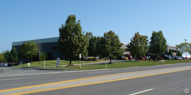
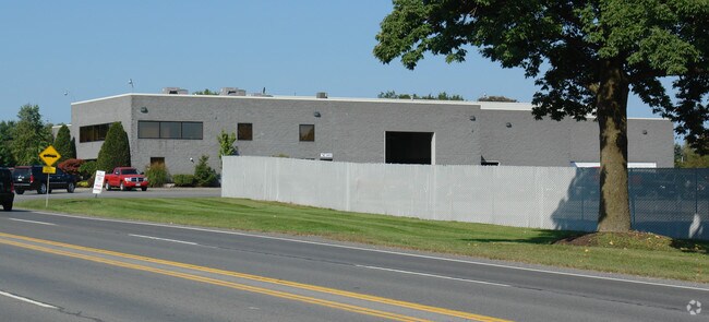
Property Record
6131 E Taft Rd, Syracuse, NY 13212

Property Detail
6131 E Taft Rd
Syracuse, NY
FL 93 1138956
312289-056-000-0001-007-000-0000
Onondaga
Warehouse
New York
B and X Area of moderate flood hazard, usually the area between the limits of the 100-year and 500-year floods.
7.000
2025
0.61 AC
2024
SE Outer Onondaga County
010600
Syracuse
47,226 SF
NEARBY LISTINGS FOR SALE OR LEASE
DEMOGRAPHICS near 6131 E Taft Rd
1 mile
3 mile
5 mile
2025 Total Population
1,852
24,357
115,059
2030 Population
1,809
23,915
112,971
Pop Growth 2025-2030
(2.32%)
(1.81%)
(1.81%)
Average Age
44
43
41
2025 Total Households
830
10,642
48,820
HH Growth 2025-2030
(2.41%)
(1.95%)
(1.90%)
Median Household Inc
$89,858
$77,307
$71,325
Avg Household Size
2.20
2.20
2.30
2025 Avg HH Vehicles
2.00
2.00
2.00
Median Home Value
$162,812
$169,135
$171,090
Median Year Built
1955
1958
1958
Nearby Places
Map Layers
Map Styles
 Street
 Aerial
Transit
 Traffic
 Biking
Places
Listings with unknown addresses are not visible on the map
- Restaurants
- Banks
- Shops
- Fitness
- Groceries
PUBLIC TRANSPORTATION
COMMUTER RAIL
Drive
Walk
Distance
12 min
7.0 mi
AIRPORT
Syracuse Hancock International
Drive
Walk
Distance
Syracuse Hancock International
10 min
4.1 mi
Nearby Properties
Address
Land Use
TOTAL SIZE
Lot Size
Zoning
Address
Land Use
TOTAL SIZE
Lot Size
Zoning
569,463 SF
94.77 AC
06 - INDUS
Address
Land Use
TOTAL SIZE
Lot Size
Zoning
80,845 SF
14.04 AC
06 - INDUS
Address
Land Use
TOTAL SIZE
Lot Size
Zoning
116,580 SF
18.46 AC
06 - INDUS
Address
Land Use
TOTAL SIZE
Lot Size
Zoning
439,670 SF
74.73 AC
C-G
Address
Land Use
TOTAL SIZE
Lot Size
Zoning
22.16 AC
06 - INDUS
Address
Land Use
TOTAL SIZE
Lot Size
Zoning
157,010 SF
36.98 AC
Address
Land Use
TOTAL SIZE
Lot Size
Zoning
157,497 SF
14.56 AC
06 - INDUS
Address
Land Use
TOTAL SIZE
Lot Size
Zoning
5.39 AC
06 - INDUS
Address
Land Use
TOTAL SIZE
Lot Size
Zoning
110,105 SF
26.68 AC
06 - INDUS
Address
Land Use
TOTAL SIZE
Lot Size
Zoning
89,985 SF
11.37 AC
06 - INDUS
Address
Land Use
TOTAL SIZE
Lot Size
Zoning
218,439 SF
18.85 AC
Address
Land Use
TOTAL SIZE
Lot Size
Zoning
2,025 SF
267.94 AC
06 - INDUS
Address
Land Use
TOTAL SIZE
Lot Size
Zoning
165,954 SF
10.66 AC
06 - INDUS
Address
Land Use
TOTAL SIZE
Lot Size
Zoning
246,172 SF
16.65 AC
Address
Land Use
TOTAL SIZE
Lot Size
Zoning
32,840 SF
26.60 AC
05 - COMME
Address
Land Use
TOTAL SIZE
Lot Size
Zoning
110,811 SF
11.46 AC
06 - INDUS
Address
Land Use
TOTAL SIZE
Lot Size
Zoning
203,345 SF
18.17 AC
Address
Land Use
TOTAL SIZE
Lot Size
Zoning
84,048 SF
19.42 AC
Address
Land Use
TOTAL SIZE
Lot Size
Zoning
70,668 SF
5.35 AC
05 - COMME
Address
Land Use
TOTAL SIZE
Lot Size
Zoning
69,910 SF
16.01 AC
06 - INDUS
Address
Land Use
TOTAL SIZE
Lot Size
Zoning
169,511 SF
4.25 AC
01 - NOT Z
Address
Land Use
TOTAL SIZE
Lot Size
Zoning
206,807 SF
46 AC
06 - INDUS
Address
Land Use
TOTAL SIZE
Lot Size
Zoning
125,400 SF
18.11 AC
GC
Address
Land Use
TOTAL SIZE
Lot Size
Zoning
125,684 SF
25.61 AC
06 - INDUS
Address
Land Use
TOTAL SIZE
Lot Size
Zoning
49,160 SF
7.23 AC
06 - INDUS
Address
Land Use
TOTAL SIZE
Lot Size
Zoning
92,538 SF
19.96 AC
06 - INDUS
Address
Land Use
TOTAL SIZE
Lot Size
Zoning
37,955 SF
10 AC
06 - INDUS
Address
Land Use
TOTAL SIZE
Lot Size
Zoning
120,068 SF
9.26 AC
GCPLUS
Address
Land Use
TOTAL SIZE
Lot Size
Zoning
141,472 SF
12.38 AC
C-G
The World's #1 Commercial Real Estate Marketplace
Connect with us
© 2026 CoStar Group
The information above has been obtained from sources believed reliable. While we do not doubt its accuracy we have not verified it and make no guarantee, warranty or representation about it. It is your responsibility to independently confirm its accuracy and completeness. Any projections, opinions, assumptions, or estimates used are for example only and do not represent the current or future performance of the property. The value of this transaction to you depends on tax and other factors which should be evaluated by your tax, financial, and legal advisors. You and your advisors should conduct a careful, independent investigation of the property to determine to your satisfaction the suitability of the property for your needs.