Property Record
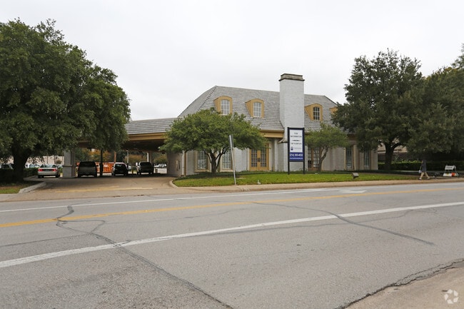
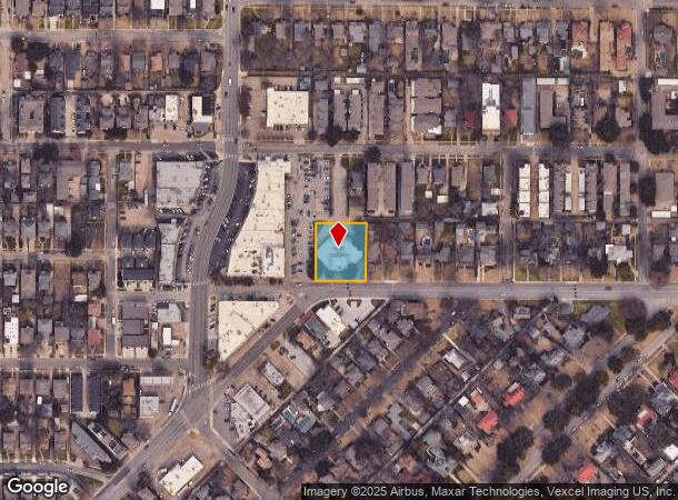
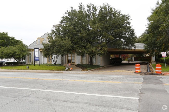
6131 La Vista Dr, Dallas, TX 75214
NEARBY LISTINGS FOR SALE OR LEASE
-
-
-
-
-
-
-
-
-
-
-
No Photo
-
View all Dallas listings for sale on LoopNet.com
Property Detail
6131 La Vista Dr
Dallas-Fort Worth-Arlington, TX
Robert Ray Abs 1242
00000202228000000
BLK 2141 TR 5 & 6 & BLK 2142 TR 11 ACS 0.5854 INT202400183149 DD09102024 CO-DC 2141 000 00500 1DA2141 000
Financialbuilding
Dallas
X
Texas
48113C0335K
5
2024
0.59 AC
2025
Lakewood
008000
Dallas/Ft Worth
4,152 SF
DEMOGRAPHICS near 6131 La Vista Dr
1 Mile
3 Mile
5 Mile
2024 Total Population
23,358
186,866
433,148
2029 Population
23,563
188,527
436,301
Pop Growth 2024-2029
+ 0.88%
+ 0.89%
+ 0.73%
Average Age
37
37
37
2024 Total Households
11,644
96,423
205,809
HH Growth 2024-2029
+ 0.85%
+ 1.02%
+ 0.84%
Median Household Inc
$86,506
$84,139
$71,960
Avg Household Size
2.00
1.90
2.00
2024 Avg HH Vehicles
2.00
1.00
1.00
Median Home Value
$564,783
$500,332
$456,950
Median Year Built
1972
1992
1986
Nearby Places
Map Layers
Map Styles
 Street
 Aerial
- Restaurants
- Banks
- Shops
- Fitness
- Groceries
PUBLIC TRANSPORTATION
COMMUTER RAIL
DRIVE
WALK
Distance
10 min
4.0 mi
DRIVE
WALK
Distance
14 min
6.0 mi
AIRPORT
Dallas Love Field
DRIVE
WALK
Distance
Dallas Love Field
18 min
7.0 mi
Dallas-Fort Worth International
DRIVE
WALK
Distance
Dallas-Fort Worth International
35 min
23.6 mi
Nearby Properties
Address
Land Use
TOTAL SIZE
Lot Size
Zoning
Address
Land Use
TOTAL SIZE
Lot Size
Zoning
1,634,356 SF
92.90 AC
Z421
Address
Land Use
TOTAL SIZE
Lot Size
Zoning
3,713,071 SF
9.94 AC
Address
Land Use
TOTAL SIZE
Lot Size
Zoning
1,676,176 SF
2.18 AC
Z239
Address
Land Use
TOTAL SIZE
Lot Size
Zoning
906,730 SF
3.09 AC
Z239
Address
Land Use
TOTAL SIZE
Lot Size
Zoning
858,872 SF
23.90 AC
Z421
Address
Land Use
TOTAL SIZE
Lot Size
Zoning
731,849 SF
3.13 AC
Z239
Address
Land Use
TOTAL SIZE
Lot Size
Zoning
1,291,660 SF
2.56 AC
Z248
Address
Land Use
TOTAL SIZE
Lot Size
Zoning
1,026,046 SF
2.89 AC
Z248
Address
Land Use
TOTAL SIZE
Lot Size
Zoning
864,909 SF
3.02 AC
Z248
Address
Land Use
TOTAL SIZE
Lot Size
Zoning
1,001,504 SF
3.37 AC
Z151
Address
Land Use
TOTAL SIZE
Lot Size
Zoning
100 SF
27.05 AC
Z421
Address
Land Use
TOTAL SIZE
Lot Size
Zoning
1,980,000 SF
2.57 AC
Z21
Address
Land Use
TOTAL SIZE
Lot Size
Zoning
763,198 SF
3.01 AC
Z248
Address
Land Use
TOTAL SIZE
Lot Size
Zoning
486,300 SF
1.55 AC
Z239
Address
Land Use
TOTAL SIZE
Lot Size
Zoning
906,627 SF
3.83 AC
Z239
Address
Land Use
TOTAL SIZE
Lot Size
Zoning
226,331 SF
1.12 AC
Address
Land Use
TOTAL SIZE
Lot Size
Zoning
536,874 SF
1.03 AC
Z239
Address
Land Use
TOTAL SIZE
Lot Size
Zoning
2,695,010 SF
8.69 AC
Z239
Address
Land Use
TOTAL SIZE
Lot Size
Zoning
545,752 SF
1.33 AC
Z239
Address
Land Use
TOTAL SIZE
Lot Size
Zoning
1,848,034 SF
2.29 AC
Z21
Address
Land Use
TOTAL SIZE
Lot Size
Zoning
551,032 SF
3.13 AC
Z239
Address
Land Use
TOTAL SIZE
Lot Size
Zoning
1,003,243 SF
2.07 AC
Z21
Address
Land Use
TOTAL SIZE
Lot Size
Zoning
763,340 SF
8.31 AC
Z165
Address
Land Use
TOTAL SIZE
Lot Size
Zoning
447,418 SF
5.69 AC
Z236
Address
Land Use
TOTAL SIZE
Lot Size
Zoning
539,723 SF
0.58 AC
Z239
Address
Land Use
TOTAL SIZE
Lot Size
Zoning
446,593 SF
0.93 AC
Address
Land Use
TOTAL SIZE
Lot Size
Zoning
3,398,834 SF
13.45 AC
Z151
Address
Land Use
TOTAL SIZE
Lot Size
Zoning
659,884 SF
5.77 AC
Z151
Address
Land Use
TOTAL SIZE
Lot Size
Zoning
432,919 SF
0.69 AC
Z21
Address
Land Use
TOTAL SIZE
Lot Size
Zoning
814,976 SF
8.72 AC
Z151
The World's #1 Commercial Real Estate Marketplace
Connect with us
© 2025 CoStar Group
The information above has been obtained from sources believed reliable. While we do not doubt its accuracy we have not verified it and make no guarantee, warranty or representation about it. It is your responsibility to independently confirm its accuracy and completeness. Any projections, opinions, assumptions, or estimates used are for example only and do not represent the current or future performance of the property. The value of this transaction to you depends on tax and other factors which should be evaluated by your tax, financial, and legal advisors. You and your advisors should conduct a careful, independent investigation of the property to determine to your satisfaction the suitability of the property for your needs.