Property Record
6131 Sundance Rd, Blackshear, GA 31516
Save to a Folder
{{folder.Name}}
{{folder.ListingIds.length}} Properties
{{folder.ListingIds.length}} Property
Create a New Folder
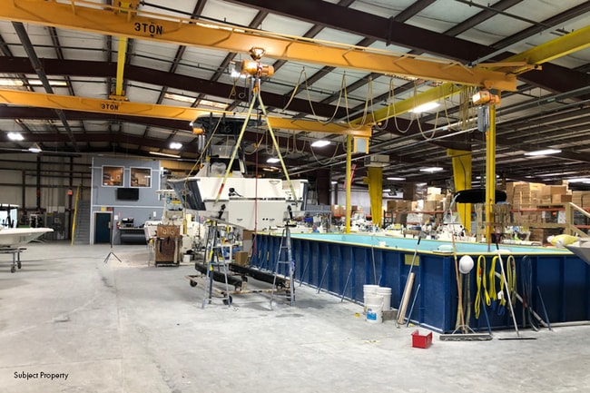
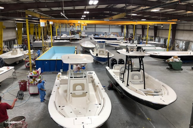
Property Detail
6131 Sundance Rd
036-013-G
LL4 LD9 PL15-289
Officebuilding
PIERCE
I
Georgia
B and X Area of moderate flood hazard, usually the area between the limits of the 100-year and 500-year floods.
8.92 AC
2025
Georgia South Area
2025
Other Market Areas
960401
Waycross, GA
1,288 SF
NEARBY LISTINGS FOR SALE OR LEASE
-
-
View all Blackshear listings for sale on LoopNet.com
DEMOGRAPHICS near 6131 Sundance Rd
1 mile
3 mile
5 mile
2025 Total Population
676
7,445
18,035
2030 Population
707
7,749
18,469
Pop Growth 2025-2030
+ 4.59%
+ 4.08%
+ 2.41%
Average Age
40
40
41
2025 Total Households
264
2,897
7,001
HH Growth 2025-2030
+ 4.92%
+ 4.18%
+ 2.36%
Median Household Inc
$71,718
$51,329
$58,413
Avg Household Size
2.50
2.50
2.50
2025 Avg HH Vehicles
2.00
2.00
2.00
Median Home Value
$159,154
$158,376
$167,985
Median Year Built
1990
1989
1985
Nearby Places
Map Layers
Map Styles
 Street
 Aerial
Layers
 Traffic
 Biking
Places
Listings with unknown addresses are not visible on the map
- Restaurants
- Banks
- Shops
- Fitness
- Groceries
SALE & LEASE HISTORY
LISTING DATE
SALE/LEASE

Sep 25, 2025
For Sale
Nearby Properties
Address
Land Use
TOTAL SIZE
Lot Size
Zoning
Address
Land Use
TOTAL SIZE
Lot Size
Zoning
51,640 SF
17.20 AC
I
Address
Land Use
TOTAL SIZE
Lot Size
Zoning
6,796 SF
84.19 AC
I
Address
Land Use
TOTAL SIZE
Lot Size
Zoning
24,684 SF
4.90 AC
C
Address
Land Use
TOTAL SIZE
Lot Size
Zoning
3,294 SF
10.56 AC
SF
Address
Land Use
TOTAL SIZE
Lot Size
Zoning
26,391 SF
6.49 AC
C
Address
Land Use
TOTAL SIZE
Lot Size
Zoning
47,616 SF
7.22 AC
MF
Address
Land Use
TOTAL SIZE
Lot Size
Zoning
300.57 AC
I
Address
Land Use
TOTAL SIZE
Lot Size
Zoning
51,640 SF
17.20 AC
I
Address
Land Use
TOTAL SIZE
Lot Size
Zoning
32,940 SF
4.60 AC
C
Address
Land Use
TOTAL SIZE
Lot Size
Zoning
17,500 SF
3.42 AC
C
Address
Land Use
TOTAL SIZE
Lot Size
Zoning
11,252 SF
5.22 AC
MF
Address
Land Use
TOTAL SIZE
Lot Size
Zoning
4,800 SF
1.64 AC
C
Address
Land Use
TOTAL SIZE
Lot Size
Zoning
3,920 SF
3.81 AC
C
Address
Land Use
TOTAL SIZE
Lot Size
Zoning
30,000 SF
0.69 AC
I
Address
Land Use
TOTAL SIZE
Lot Size
Zoning
8,640 SF
3.86 AC
C
Address
Land Use
TOTAL SIZE
Lot Size
Zoning
30,000 SF
0.69 AC
I
Address
Land Use
TOTAL SIZE
Lot Size
Zoning
12,500 SF
2.36 AC
C
Address
Land Use
TOTAL SIZE
Lot Size
Zoning
4,750 SF
1.68 AC
C
Address
Land Use
TOTAL SIZE
Lot Size
Zoning
6,480 SF
1.79 AC
C
Address
Land Use
TOTAL SIZE
Lot Size
Zoning
9,322 SF
1.33 AC
C
Address
Land Use
TOTAL SIZE
Lot Size
Zoning
6,400 SF
3.39 AC
C
Address
Land Use
TOTAL SIZE
Lot Size
Zoning
9,000 SF
6.50 AC
C
Address
Land Use
TOTAL SIZE
Lot Size
Zoning
4,000 SF
42.10 AC
C
Address
Land Use
TOTAL SIZE
Lot Size
Zoning
10,825 SF
1.77 AC
C
Address
Land Use
TOTAL SIZE
Lot Size
Zoning
23,900 SF
4.12 AC
NC
Address
Land Use
TOTAL SIZE
Lot Size
Zoning
9,020 SF
1.77 AC
C
Address
Land Use
TOTAL SIZE
Lot Size
Zoning
23,710 SF
1.40 AC
C
Address
Land Use
TOTAL SIZE
Lot Size
Zoning
26,250 SF
21.53 AC
I
Address
Land Use
TOTAL SIZE
Lot Size
Zoning
10,500 SF
2.68 AC
C
The World's #1 Commercial Real Estate Marketplace
Connect with us
© 2026 CoStar Group
The information above has been obtained from sources believed reliable. While we do not doubt its accuracy we have not verified it and make no guarantee, warranty or representation about it. It is your responsibility to independently confirm its accuracy and completeness. Any projections, opinions, assumptions, or estimates used are for example only and do not represent the current or future performance of the property. The value of this transaction to you depends on tax and other factors which should be evaluated by your tax, financial, and legal advisors. You and your advisors should conduct a careful, independent investigation of the property to determine to your satisfaction the suitability of the property for your needs.