Property Record
6133 Highway 2830, Owensboro, KY 42303

NEARBY LISTINGS FOR SALE OR LEASE
-
-
View all Owensboro listings for sale on LoopNet.com
Property Detail
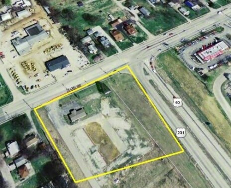
6133 Highway 2830
072-00-00-053-00-000
72-536133 HWY 2830161.982 ACRES
Commercialnec
Daviess
AE
Kentucky
21059C0135E
161.98 AC
2025
Kentucky West Area
2025
Other Market Areas
000401
Owensboro, KY
26,965 SF
DEMOGRAPHICS near 6133 Highway 2830
1 Mile
3 Mile
5 Mile
2024 Total Population
363
7,543
25,877
2029 Population
378
7,711
26,235
Pop Growth 2024-2029
+ 4.13%
+ 2.23%
+ 1.38%
Average Age
35
39
40
2024 Total Households
129
2,645
9,800
HH Growth 2024-2029
+ 4.65%
+ 2.38%
+ 1.42%
Median Household Inc
$66,750
$74,507
$59,306
Avg Household Size
2.80
2.60
2.50
2024 Avg HH Vehicles
2.00
2.00
2.00
Median Home Value
$93,999
$181,532
$169,849
Median Year Built
1985
1983
1980
Nearby Places
Map Layers
Map Styles
 Street
 Aerial
- Restaurants
- Banks
- Shops
- Fitness
- Groceries
Nearby Properties
Address
Land Use
TOTAL SIZE
Lot Size
Zoning
Address
Land Use
TOTAL SIZE
Lot Size
Zoning
69,512 SF
175.17 AC
Address
Land Use
TOTAL SIZE
Lot Size
Zoning
69,912 SF
20.30 AC
Address
Land Use
TOTAL SIZE
Lot Size
Zoning
65,400 SF
8.93 AC
Address
Land Use
TOTAL SIZE
Lot Size
Zoning
4,820 SF
51.49 AC
Address
Land Use
TOTAL SIZE
Lot Size
Zoning
17,600 SF
91.51 AC
Address
Land Use
TOTAL SIZE
Lot Size
Zoning
77,048 SF
19.18 AC
Address
Land Use
TOTAL SIZE
Lot Size
Zoning
64,082 SF
11.89 AC
Address
Land Use
TOTAL SIZE
Lot Size
Zoning
59,532 SF
92.59 AC
Address
Land Use
TOTAL SIZE
Lot Size
Zoning
15,259 SF
Address
Land Use
TOTAL SIZE
Lot Size
Zoning
32,628 SF
29.25 AC
Address
Land Use
TOTAL SIZE
Lot Size
Zoning
35,000 SF
Address
Land Use
TOTAL SIZE
Lot Size
Zoning
26,372 SF
Address
Land Use
TOTAL SIZE
Lot Size
Zoning
Address
Land Use
TOTAL SIZE
Lot Size
Zoning
25,098 SF
66.87 AC
Address
Land Use
TOTAL SIZE
Lot Size
Zoning
51,821 SF
13.66 AC
Address
Land Use
TOTAL SIZE
Lot Size
Zoning
1,120 SF
12.78 AC
Address
Land Use
TOTAL SIZE
Lot Size
Zoning
4,000 SF
39.55 AC
Address
Land Use
TOTAL SIZE
Lot Size
Zoning
59,135 SF
30.29 AC
Address
Land Use
TOTAL SIZE
Lot Size
Zoning
15,300 SF
3.35 AC
Address
Land Use
TOTAL SIZE
Lot Size
Zoning
24,000 SF
7.60 AC
Address
Land Use
TOTAL SIZE
Lot Size
Zoning
1,416 SF
19.92 AC
Address
Land Use
TOTAL SIZE
Lot Size
Zoning
2,240 SF
1.03 AC
Address
Land Use
TOTAL SIZE
Lot Size
Zoning
16,789 SF
9.11 AC
Address
Land Use
TOTAL SIZE
Lot Size
Zoning
10.73 AC
Address
Land Use
TOTAL SIZE
Lot Size
Zoning
42,666 SF
14.74 AC
Address
Land Use
TOTAL SIZE
Lot Size
Zoning
Address
Land Use
TOTAL SIZE
Lot Size
Zoning
2,344 SF
28.16 AC
Address
Land Use
TOTAL SIZE
Lot Size
Zoning
5,400 SF
Address
Land Use
TOTAL SIZE
Lot Size
Zoning
3,040 SF
53.62 AC
The World's #1 Commercial Real Estate Marketplace
Connect with us
© 2026 CoStar Group
The information above has been obtained from sources believed reliable. While we do not doubt its accuracy we have not verified it and make no guarantee, warranty or representation about it. It is your responsibility to independently confirm its accuracy and completeness. Any projections, opinions, assumptions, or estimates used are for example only and do not represent the current or future performance of the property. The value of this transaction to you depends on tax and other factors which should be evaluated by your tax, financial, and legal advisors. You and your advisors should conduct a careful, independent investigation of the property to determine to your satisfaction the suitability of the property for your needs.