Property Record
6135 N Rose Ave, Oxnard, CA 93036

Property Detail
6135 N Rose Ave
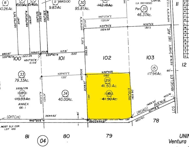
147-0-060-290
MISC 3 PG 26 LOT 102
Horticulturegrowinghousesagricultural
Ventura
AE/MRP
California
B and X Area of moderate flood hazard, usually the area between the limits of the 100-year and 500-year floods.
41.50 AC
2024
Oxnard/Pt Hueneme
2025
Los Angeles
009300
Oxnard-Thousand Oaks-Ventura, CA
NEARBY LISTINGS FOR SALE OR LEASE
DEMOGRAPHICS near 6135 N Rose Ave
1 mile
3 mile
5 mile
2025 Total Population
14
41,108
150,258
2030 Population
13
40,755
149,096
Pop Growth 2025-2030
(7.14%)
(0.86%)
(0.77%)
Average Age
40
39
39
2025 Total Households
4
13,493
47,816
HH Growth 2025-2030
0.00%
(0.87%)
(0.85%)
Median Household Inc
$250,000
$111,179
$108,537
Avg Household Size
2.50
2.90
3.00
2025 Avg HH Vehicles
3.00
2.00
2.00
Median Home Value
$1,150,000
$732,920
$753,078
Median Year Built
1959
1981
1980
Nearby Places
Map Layers
Map Styles
 Street
 Aerial
Transit
 Traffic
 Biking
Places
Listings with unknown addresses are not visible on the map
- Restaurants
- Banks
- Shops
- Fitness
- Groceries
PUBLIC TRANSPORTATION
COMMUTER RAIL
Oxnard (Ventura County Line - Southern California Regional Rail Authority (Metrolink))
Drive
Walk
Distance
Oxnard (Ventura County Line - Southern California Regional Rail Authority (Metrolink))
11 min
6.2 mi
East Ventura Metrolink Station (Metrolink Ventura County Line - Metrolink Trains)
Drive
Walk
Distance
East Ventura Metrolink Station (Metrolink Ventura County Line - Metrolink Trains)
11 min
6.5 mi
Freight Ports
The Port of Hueneme
Drive
Walk
Distance
The Port of Hueneme
20 min
10.6 mi
Nearby Properties
Address
Land Use
TOTAL SIZE
Lot Size
Zoning
Address
Land Use
TOTAL SIZE
Lot Size
Zoning
6.14 AC
Address
Land Use
TOTAL SIZE
Lot Size
Zoning
205,396 SF
12.48 AC
Address
Land Use
TOTAL SIZE
Lot Size
Zoning
24,154 SF
12.67 AC
R3-1
Address
Land Use
TOTAL SIZE
Lot Size
Zoning
138,475 SF
2.77 AC
Address
Land Use
TOTAL SIZE
Lot Size
Zoning
138,475 SF
2.77 AC
Address
Land Use
TOTAL SIZE
Lot Size
Zoning
4.76 AC
Address
Land Use
TOTAL SIZE
Lot Size
Zoning
2,440 SF
7.49 AC
C2
Address
Land Use
TOTAL SIZE
Lot Size
Zoning
151,422 SF
6.67 AC
Address
Land Use
TOTAL SIZE
Lot Size
Zoning
4.41 AC
Address
Land Use
TOTAL SIZE
Lot Size
Zoning
16,237 SF
4.23 AC
Address
Land Use
TOTAL SIZE
Lot Size
Zoning
102,046 SF
3.72 AC
Address
Land Use
TOTAL SIZE
Lot Size
Zoning
17.60 AC
Address
Land Use
TOTAL SIZE
Lot Size
Zoning
87,804 SF
6.68 AC
RPD-
Address
Land Use
TOTAL SIZE
Lot Size
Zoning
339.53 AC
Address
Land Use
TOTAL SIZE
Lot Size
Zoning
3,725 SF
429.19 AC
AE
Address
Land Use
TOTAL SIZE
Lot Size
Zoning
14,353 SF
3.89 AC
Address
Land Use
TOTAL SIZE
Lot Size
Zoning
1.09 AC
Address
Land Use
TOTAL SIZE
Lot Size
Zoning
19,826 SF
6.14 AC
C2
Address
Land Use
TOTAL SIZE
Lot Size
Zoning
45,925 SF
1.68 AC
Address
Land Use
TOTAL SIZE
Lot Size
Zoning
64,976 SF
3 AC
R3-5D
Address
Land Use
TOTAL SIZE
Lot Size
Zoning
53,658 SF
3.18 AC
RPD-1
Address
Land Use
TOTAL SIZE
Lot Size
Zoning
68,527 SF
6.36 AC
CR
Address
Land Use
TOTAL SIZE
Lot Size
Zoning
101,975 SF
5.34 AC
C2
Address
Land Use
TOTAL SIZE
Lot Size
Zoning
11,889 SF
3.48 AC
C2
Address
Land Use
TOTAL SIZE
Lot Size
Zoning
10,995 SF
17.26 AC
M2
Address
Land Use
TOTAL SIZE
Lot Size
Zoning
1.59 AC
POD
Address
Land Use
TOTAL SIZE
Lot Size
Zoning
34,819 SF
1.28 AC
R3-2
Address
Land Use
TOTAL SIZE
Lot Size
Zoning
30,680 SF
3.97 AC
C2
Address
Land Use
TOTAL SIZE
Lot Size
Zoning
3.89 AC
7
Address
Land Use
TOTAL SIZE
Lot Size
Zoning
2.88 AC
POD
The World's #1 Commercial Real Estate Marketplace
Connect with us
© 2026 CoStar Group
The information above has been obtained from sources believed reliable. While we do not doubt its accuracy we have not verified it and make no guarantee, warranty or representation about it. It is your responsibility to independently confirm its accuracy and completeness. Any projections, opinions, assumptions, or estimates used are for example only and do not represent the current or future performance of the property. The value of this transaction to you depends on tax and other factors which should be evaluated by your tax, financial, and legal advisors. You and your advisors should conduct a careful, independent investigation of the property to determine to your satisfaction the suitability of the property for your needs.