Property Record
6133 W Belmont Ave, Chicago, IL 60634
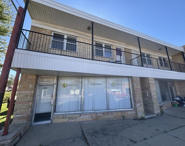

This Property Is For Sale
NEARBY LISTINGS FOR SALE OR LEASE
Property Detail
6133 W Belmont Ave
Chicago-Naperville-Elgin, IL-IN-WI
Armstrongs Belmont
13-29-102-011-0000
(ARMSTRONGS)(BELMONT) AVE SUB OF THE WH NE NW SEC 29-40-13
Miscresidentialimprovement
Cook
X
Illinois
17031C0385J
14
2023
0.07 AC
2025
Northwest City
190401
Chicago
6,792 SF
DEMOGRAPHICS near 6133 W Belmont Ave
1 Mile
3 Mile
5 Mile
2024 Total Population
43,277
333,527
810,798
2029 Population
40,705
313,596
767,163
Pop Growth 2024-2029
(5.94%)
(5.98%)
(5.38%)
Average Age
39
40
39
2024 Total Households
13,709
118,454
306,829
HH Growth 2024-2029
(6.24%)
(6.24%)
(5.63%)
Median Household Inc
$75,482
$71,575
$72,759
Avg Household Size
3.00
2.70
2.50
2024 Avg HH Vehicles
2.00
2.00
1.00
Median Home Value
$299,985
$316,282
$341,476
Median Year Built
1947
1948
1948
Nearby Places
Map Layers
Map Styles
 Street
 Aerial
- Restaurants
- Banks
- Shops
- Fitness
- Groceries
PUBLIC TRANSPORTATION
COMMUTER RAIL
Galewood Station (Milwaukee District West Line - Northeast Illinois Regional Commuter Railroad (Metra), North Central Service - Northeast Illinois Regional Commuter Railroad (Metra))
DRIVE
WALK
Distance
Galewood Station (Milwaukee District West Line - Northeast Illinois Regional Commuter Railroad (Metra), North Central Service - Northeast Illinois Regional Commuter Railroad (Metra))
5 min
1.9 mi
Mars Station (Milwaukee District West Line - Northeast Illinois Regional Commuter Railroad (Metra), North Central Service - Northeast Illinois Regional Commuter Railroad (Metra))
DRIVE
WALK
Distance
Mars Station (Milwaukee District West Line - Northeast Illinois Regional Commuter Railroad (Metra), North Central Service - Northeast Illinois Regional Commuter Railroad (Metra))
5 min
2.1 mi
AIRPORT
Chicago O'Hare International
DRIVE
WALK
Distance
Chicago O'Hare International
18 min
9.6 mi
Chicago Midway International
DRIVE
WALK
Distance
Chicago Midway International
22 min
12.2 mi
Freight Ports
Port Milwaukee
DRIVE
WALK
Distance
Port Milwaukee
99 min
80.8 mi
Nearby Properties
Address
Land Use
TOTAL SIZE
Lot Size
Zoning
Address
Land Use
TOTAL SIZE
Lot Size
Zoning
9.90 AC
Address
Land Use
TOTAL SIZE
Lot Size
Zoning
192,365 SF
21.34 AC
PD 127
Address
Land Use
TOTAL SIZE
Lot Size
Zoning
237,832 SF
14.04 AC
PD 418
Address
Land Use
TOTAL SIZE
Lot Size
Zoning
1.04 AC
PD 130
Address
Land Use
TOTAL SIZE
Lot Size
Zoning
6.31 AC
PD 1013
Address
Land Use
TOTAL SIZE
Lot Size
Zoning
382,635 SF
5.90 AC
M1-1
Address
Land Use
TOTAL SIZE
Lot Size
Zoning
3.33 AC
PD 1013
Address
Land Use
TOTAL SIZE
Lot Size
Zoning
194,219 SF
17.26 AC
Address
Land Use
TOTAL SIZE
Lot Size
Zoning
194,582 SF
12.68 AC
PD 699
Address
Land Use
TOTAL SIZE
Lot Size
Zoning
13.33 AC
PD 127
Address
Land Use
TOTAL SIZE
Lot Size
Zoning
95,614 SF
4.20 AC
Address
Land Use
TOTAL SIZE
Lot Size
Zoning
0.43 AC
RS-2
Address
Land Use
TOTAL SIZE
Lot Size
Zoning
389,400 SF
28.83 AC
PMD 9
Address
Land Use
TOTAL SIZE
Lot Size
Zoning
277,819 SF
10.58 AC
PD 127
Address
Land Use
TOTAL SIZE
Lot Size
Zoning
897,723 SF
23.04 AC
PMD 15
Address
Land Use
TOTAL SIZE
Lot Size
Zoning
141,095 SF
9.15 AC
PD 127
Address
Land Use
TOTAL SIZE
Lot Size
Zoning
Address
Land Use
TOTAL SIZE
Lot Size
Zoning
130,310 SF
0.82 AC
PD 1371
Address
Land Use
TOTAL SIZE
Lot Size
Zoning
9,000 SF
0.34 AC
Address
Land Use
TOTAL SIZE
Lot Size
Zoning
65,243 SF
3.70 AC
Address
Land Use
TOTAL SIZE
Lot Size
Zoning
138,042 SF
11.74 AC
PD 127
Address
Land Use
TOTAL SIZE
Lot Size
Zoning
38,494 SF
0.78 AC
B3-1
Address
Land Use
TOTAL SIZE
Lot Size
Zoning
65,800 SF
0.90 AC
PD 1376
Address
Land Use
TOTAL SIZE
Lot Size
Zoning
197,709 SF
2.41 AC
Address
Land Use
TOTAL SIZE
Lot Size
Zoning
165,574 SF
3.91 AC
Address
Land Use
TOTAL SIZE
Lot Size
Zoning
158,000 SF
4.19 AC
M1-1
Address
Land Use
TOTAL SIZE
Lot Size
Zoning
70,345 SF
5.09 AC
Address
Land Use
TOTAL SIZE
Lot Size
Zoning
306,872 SF
3.61 AC
PD 617
Address
Land Use
TOTAL SIZE
Lot Size
Zoning
36,800 SF
1.01 AC
C2-1
Address
Land Use
TOTAL SIZE
Lot Size
Zoning
376,584 SF
The World's #1 Commercial Real Estate Marketplace
Connect with us
© 2026 CoStar Group
The information above has been obtained from sources believed reliable. While we do not doubt its accuracy we have not verified it and make no guarantee, warranty or representation about it. It is your responsibility to independently confirm its accuracy and completeness. Any projections, opinions, assumptions, or estimates used are for example only and do not represent the current or future performance of the property. The value of this transaction to you depends on tax and other factors which should be evaluated by your tax, financial, and legal advisors. You and your advisors should conduct a careful, independent investigation of the property to determine to your satisfaction the suitability of the property for your needs.