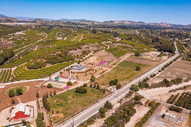
Property Record
6137 Grimes Canyon Rd, Moorpark, CA 93021

Save to a Folder
{{folder.Name}}
{{folder.ListingIds.length}} Properties
{{folder.ListingIds.length}} Property
Create a New Folder
Current Lease Availabilities
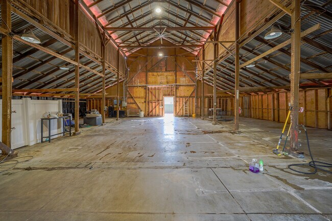
Property Detail
6137 Grimes Canyon Rd
503-0-020-285
PARCEL MAPS 16 PG 82 LOT 17
Orchard
Ventura
AE
California
A Areas with a 1% annual chance of flooding and a 26% chance of flooding over the life of a 30-year mortgage.
17.71 AC
2025
Moorpark/Simi Valley
2026
Los Angeles
009300
Oxnard-Thousand Oaks-Ventura, CA
4,422 SF
NEARBY LISTINGS FOR SALE OR LEASE
DEMOGRAPHICS near 6137 Grimes Canyon Rd
1 mile
3 mile
5 mile
2025 Total Population
208
19,018
42,085
2030 Population
203
18,780
41,435
Pop Growth 2025-2030
(2.40%)
(1.25%)
(1.54%)
Average Age
42
40
41
2025 Total Households
60
5,851
13,369
HH Growth 2025-2030
(3.33%)
(1.45%)
(1.74%)
Median Household Inc
$212,903
$153,191
$155,171
Avg Household Size
3.30
3.10
3.10
2025 Avg HH Vehicles
3.00
3.00
3.00
Median Home Value
$1,126,136
$908,953
$951,209
Median Year Built
2004
1986
1985
Nearby Places
Map Layers
Map Styles
 Street
 Aerial
Layers
 Traffic
 Biking
Places
Listings with unknown addresses are not visible on the map
- Restaurants
- Banks
- Shops
- Fitness
- Groceries
PUBLIC TRANSPORTATION
COMMUTER RAIL
Moorpark (Ventura County Line - Southern California Regional Rail Authority (Metrolink))
Drive
Walk
Distance
Moorpark (Ventura County Line - Southern California Regional Rail Authority (Metrolink))
12 min
5.2 mi
Camarillo (Ventura County Line - Southern California Regional Rail Authority (Metrolink))
Drive
Walk
Distance
Camarillo (Ventura County Line - Southern California Regional Rail Authority (Metrolink))
19 min
9.5 mi
Freight Ports
The Port of Hueneme
Drive
Walk
Distance
The Port of Hueneme
38 min
21.3 mi
Nearby Properties
Address
Land Use
TOTAL SIZE
Lot Size
Zoning
Address
Land Use
TOTAL SIZE
Lot Size
Zoning
321,174 SF
14.21 AC
Address
Land Use
TOTAL SIZE
Lot Size
Zoning
152,456 SF
7.89 AC
RPD15
Address
Land Use
TOTAL SIZE
Lot Size
Zoning
134,520 SF
6.50 AC
RPD15
Address
Land Use
TOTAL SIZE
Lot Size
Zoning
Address
Land Use
TOTAL SIZE
Lot Size
Zoning
127,176 SF
6.87 AC
Address
Land Use
TOTAL SIZE
Lot Size
Zoning
44,840 SF
1.98 AC
RPD15
Address
Land Use
TOTAL SIZE
Lot Size
Zoning
52,547 SF
10.83 AC
Address
Land Use
TOTAL SIZE
Lot Size
Zoning
11,736 SF
4.08 AC
RPD5
Address
Land Use
TOTAL SIZE
Lot Size
Zoning
105,132 SF
6.97 AC
CPD
Address
Land Use
TOTAL SIZE
Lot Size
Zoning
14,618 SF
1.27 AC
Address
Land Use
TOTAL SIZE
Lot Size
Zoning
31,751 SF
9.96 AC
Address
Land Use
TOTAL SIZE
Lot Size
Zoning
10.01 AC
Address
Land Use
TOTAL SIZE
Lot Size
Zoning
30 AC
AE
Address
Land Use
TOTAL SIZE
Lot Size
Zoning
109,206 SF
3.93 AC
M2
Address
Land Use
TOTAL SIZE
Lot Size
Zoning
24,671 SF
1.20 AC
Address
Land Use
TOTAL SIZE
Lot Size
Zoning
21,838 SF
1.62 AC
Address
Land Use
TOTAL SIZE
Lot Size
Zoning
56,852 SF
2.55 AC
M2
Address
Land Use
TOTAL SIZE
Lot Size
Zoning
1,080 SF
0.87 AC
M2
Address
Land Use
TOTAL SIZE
Lot Size
Zoning
34,243 SF
0.79 AC
CPD
Address
Land Use
TOTAL SIZE
Lot Size
Zoning
112,817 SF
3.07 AC
M2
Address
Land Use
TOTAL SIZE
Lot Size
Zoning
6.46 AC
Address
Land Use
TOTAL SIZE
Lot Size
Zoning
14,360 SF
0.66 AC
Address
Land Use
TOTAL SIZE
Lot Size
Zoning
183.96 AC
AE
Address
Land Use
TOTAL SIZE
Lot Size
Zoning
1,828 SF
1.04 AC
M2
Address
Land Use
TOTAL SIZE
Lot Size
Zoning
28,166 SF
1.10 AC
M2
Address
Land Use
TOTAL SIZE
Lot Size
Zoning
23,444 SF
1.33 AC
M2
Address
Land Use
TOTAL SIZE
Lot Size
Zoning
16,880 SF
2.51 AC
RPD5
The World's #1 Commercial Real Estate Marketplace
Connect with us
© 2026 CoStar Group
The information above has been obtained from sources believed reliable. While we do not doubt its accuracy we have not verified it and make no guarantee, warranty or representation about it. It is your responsibility to independently confirm its accuracy and completeness. Any projections, opinions, assumptions, or estimates used are for example only and do not represent the current or future performance of the property. The value of this transaction to you depends on tax and other factors which should be evaluated by your tax, financial, and legal advisors. You and your advisors should conduct a careful, independent investigation of the property to determine to your satisfaction the suitability of the property for your needs.