Property Record
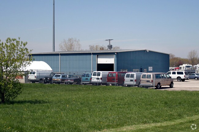
6139 N Summit St, Toledo, OH 43611


Property Detail
6139 N Summit St
83-20039
8 9 4 SW 1/4 S 145 FT N 295 FT E 446.87FT AS MEAS ON S LINE
Vehiclerentalsvehiclesales
Lucas
21-C2
Ohio
AE The base floodplain where base flood elevations are provided. AE Zones are now used on new format FIRMs instead of A1-A30 Zones.
1.54 AC
0
North Toledo
2025
Toledo
005601
Toledo, OH
4,800 SF
NEARBY LISTINGS FOR SALE OR LEASE
DEMOGRAPHICS near 6139 N Summit St
1 mile
3 mile
5 mile
2025 Total Population
5,369
17,656
60,331
2030 Population
5,271
17,458
60,296
Pop Growth 2025-2030
(1.83%)
(1.12%)
(0.06%)
Average Age
44
42
40
2025 Total Households
2,350
7,538
25,046
HH Growth 2025-2030
(1.83%)
(1.18%)
(0.14%)
Median Household Inc
$66,454
$64,362
$49,284
Avg Household Size
2.20
2.30
2.30
2025 Avg HH Vehicles
2.00
2.00
2.00
Median Home Value
$144,724
$136,496
$108,901
Median Year Built
1959
1959
1956
Nearby Places
Map Layers
Map Styles
 Street
 Aerial
Layers
 Traffic
 Biking
Places
Listings with unknown addresses are not visible on the map
- Restaurants
- Banks
- Shops
- Fitness
- Groceries
PUBLIC TRANSPORTATION
COMMUTER RAIL
Toledo (Capitol Limited - Amtrak, Lake Shore Limited - Amtrak)
Drive
Walk
Distance
Toledo (Capitol Limited - Amtrak, Lake Shore Limited - Amtrak)
15 min
8.4 mi
AIRPORT
Eugene F Kranz Toledo Express
Drive
Walk
Distance
Eugene F Kranz Toledo Express
45 min
25.9 mi
Freight Ports
Port of Toledo
Drive
Walk
Distance
Port of Toledo
21 min
10.1 mi
Nearby Properties
Address
Land Use
TOTAL SIZE
Lot Size
Zoning
Address
Land Use
TOTAL SIZE
Lot Size
Zoning
286,525 SF
105.33 AC
10-RS6
Address
Land Use
TOTAL SIZE
Lot Size
Zoning
28.51 AC
10-IG
Address
Land Use
TOTAL SIZE
Lot Size
Zoning
230,400 SF
18 AC
10-CR
Address
Land Use
TOTAL SIZE
Lot Size
Zoning
90,113 SF
8.12 AC
21-PO
Address
Land Use
TOTAL SIZE
Lot Size
Zoning
175,978 SF
10.02 AC
10-IL
Address
Land Use
TOTAL SIZE
Lot Size
Zoning
106.75 AC
AC = AG
Address
Land Use
TOTAL SIZE
Lot Size
Zoning
92,888 SF
20.24 AC
10-IL
Address
Land Use
TOTAL SIZE
Lot Size
Zoning
159,798 SF
8.32 AC
10-IL
Address
Land Use
TOTAL SIZE
Lot Size
Zoning
123,258 SF
23.59 AC
Address
Land Use
TOTAL SIZE
Lot Size
Zoning
191,297 SF
28.74 AC
10-CRSO
Address
Land Use
TOTAL SIZE
Lot Size
Zoning
48,427 SF
20.29 AC
Address
Land Use
TOTAL SIZE
Lot Size
Zoning
53,306 SF
2 AC
10-CO
Address
Land Use
TOTAL SIZE
Lot Size
Zoning
70,404 SF
8.07 AC
10-RS6
Address
Land Use
TOTAL SIZE
Lot Size
Zoning
123,125 SF
18.93 AC
Address
Land Use
TOTAL SIZE
Lot Size
Zoning
42,780 SF
1 AC
10-CO
Address
Land Use
TOTAL SIZE
Lot Size
Zoning
202,584 SF
15.12 AC
10-IG
Address
Land Use
TOTAL SIZE
Lot Size
Zoning
5,416 SF
87.73 AC
MHP
Address
Land Use
TOTAL SIZE
Lot Size
Zoning
174,276 SF
14.50 AC
Address
Land Use
TOTAL SIZE
Lot Size
Zoning
79,128 SF
9.01 AC
10-CRSO
Address
Land Use
TOTAL SIZE
Lot Size
Zoning
322,018 SF
20.24 AC
10-IG
Address
Land Use
TOTAL SIZE
Lot Size
Zoning
220,400 SF
13.32 AC
10-IG
Address
Land Use
TOTAL SIZE
Lot Size
Zoning
181,828 SF
17.74 AC
10-IG
Address
Land Use
TOTAL SIZE
Lot Size
Zoning
6,696 SF
81.72 AC
MARINA
Address
Land Use
TOTAL SIZE
Lot Size
Zoning
163,319 SF
66.75 AC
10-IG
Address
Land Use
TOTAL SIZE
Lot Size
Zoning
61,940 SF
8 AC
10-IL
Address
Land Use
TOTAL SIZE
Lot Size
Zoning
41,492 SF
6.13 AC
10-IL
Address
Land Use
TOTAL SIZE
Lot Size
Zoning
49,839 SF
2 AC
10-CO
Address
Land Use
TOTAL SIZE
Lot Size
Zoning
225,222 SF
20.57 AC
10-IG
Address
Land Use
TOTAL SIZE
Lot Size
Zoning
205,638 SF
17.22 AC
10-IG
Address
Land Use
TOTAL SIZE
Lot Size
Zoning
38,236 SF
4.23 AC
10-IG
The World's #1 Commercial Real Estate Marketplace
Connect with us
© 2026 CoStar Group
The information above has been obtained from sources believed reliable. While we do not doubt its accuracy we have not verified it and make no guarantee, warranty or representation about it. It is your responsibility to independently confirm its accuracy and completeness. Any projections, opinions, assumptions, or estimates used are for example only and do not represent the current or future performance of the property. The value of this transaction to you depends on tax and other factors which should be evaluated by your tax, financial, and legal advisors. You and your advisors should conduct a careful, independent investigation of the property to determine to your satisfaction the suitability of the property for your needs.