Property Record
6139 State Route 39, Millersburg, OH 44654


NEARBY LISTINGS FOR SALE OR LEASE
-
-
View all Millersburg listings for sale on LoopNet.com
Property Detail
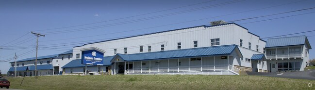
6139 State Route 39
01-00906.000
R6 T9 S4 LOT 5 PT 4.263A B-03 RES 4/03
Storebuilding
Holmes
X
Ohio
39075C0215D
5
2024
4.26 AC
2024
Ohio North Area
976403
Other Market Areas
700 SF
DEMOGRAPHICS near 6139 State Route 39
1 Mile
3 Mile
5 Mile
2024 Total Population
431
4,724
14,708
2029 Population
435
4,755
14,893
Pop Growth 2024-2029
+ 0.93%
+ 0.66%
+ 1.26%
Average Age
35
36
36
2024 Total Households
123
1,381
4,642
HH Growth 2024-2029
+ 0.81%
+ 0.43%
+ 1.27%
Median Household Inc
$76,667
$73,700
$67,040
Avg Household Size
3.40
3.30
3.00
2024 Avg HH Vehicles
1.00
1.00
2.00
Median Home Value
$295,999
$309,198
$295,149
Median Year Built
1991
1990
1988
Nearby Places
Map Layers
Map Styles
 Street
 Aerial
- Restaurants
- Banks
- Shops
- Fitness
- Groceries
PUBLIC TRANSPORTATION
AIRPORT
Akron-Canton Regional
DRIVE
WALK
Distance
Akron-Canton Regional
62 min
43.3 mi
Nearby Properties
Address
Land Use
TOTAL SIZE
Lot Size
Zoning
Address
Land Use
TOTAL SIZE
Lot Size
Zoning
74,644 SF
16.15 AC
Address
Land Use
TOTAL SIZE
Lot Size
Zoning
2,046 SF
2.50 AC
Address
Land Use
TOTAL SIZE
Lot Size
Zoning
162 SF
8.68 AC
Address
Land Use
TOTAL SIZE
Lot Size
Zoning
40,000 SF
7.77 AC
Address
Land Use
TOTAL SIZE
Lot Size
Zoning
68,800 SF
13.89 AC
Address
Land Use
TOTAL SIZE
Lot Size
Zoning
1,456 SF
174.80 AC
Address
Land Use
TOTAL SIZE
Lot Size
Zoning
59,800 SF
23.75 AC
Address
Land Use
TOTAL SIZE
Lot Size
Zoning
53,638 SF
4.43 AC
Address
Land Use
TOTAL SIZE
Lot Size
Zoning
1,276 SF
10.89 AC
Address
Land Use
TOTAL SIZE
Lot Size
Zoning
1,160 SF
38.78 AC
Address
Land Use
TOTAL SIZE
Lot Size
Zoning
6,000 SF
6.91 AC
Address
Land Use
TOTAL SIZE
Lot Size
Zoning
28,500 SF
1.75 AC
Address
Land Use
TOTAL SIZE
Lot Size
Zoning
18,217 SF
4.86 AC
Address
Land Use
TOTAL SIZE
Lot Size
Zoning
50,600 SF
7.02 AC
Address
Land Use
TOTAL SIZE
Lot Size
Zoning
2,813 SF
1.25 AC
Address
Land Use
TOTAL SIZE
Lot Size
Zoning
5,698 SF
6.82 AC
Address
Land Use
TOTAL SIZE
Lot Size
Zoning
11,465 SF
1.30 AC
Address
Land Use
TOTAL SIZE
Lot Size
Zoning
3,264 SF
30 AC
Address
Land Use
TOTAL SIZE
Lot Size
Zoning
2,229 SF
6.23 AC
Address
Land Use
TOTAL SIZE
Lot Size
Zoning
42,000 SF
10 AC
Address
Land Use
TOTAL SIZE
Lot Size
Zoning
174 SF
11.48 AC
Address
Land Use
TOTAL SIZE
Lot Size
Zoning
9,600 SF
16.53 AC
Address
Land Use
TOTAL SIZE
Lot Size
Zoning
25,000 SF
2 AC
Address
Land Use
TOTAL SIZE
Lot Size
Zoning
8,581 SF
0.77 AC
Address
Land Use
TOTAL SIZE
Lot Size
Zoning
1,520 SF
3.25 AC
Address
Land Use
TOTAL SIZE
Lot Size
Zoning
37,200 SF
3.72 AC
Address
Land Use
TOTAL SIZE
Lot Size
Zoning
9,216 SF
1 AC
Address
Land Use
TOTAL SIZE
Lot Size
Zoning
1,172 SF
5.20 AC
Address
Land Use
TOTAL SIZE
Lot Size
Zoning
4,006 SF
0.93 AC
Address
Land Use
TOTAL SIZE
Lot Size
Zoning
19,408 SF
17.39 AC
The World's #1 Commercial Real Estate Marketplace
Connect with us
© 2026 CoStar Group
The information above has been obtained from sources believed reliable. While we do not doubt its accuracy we have not verified it and make no guarantee, warranty or representation about it. It is your responsibility to independently confirm its accuracy and completeness. Any projections, opinions, assumptions, or estimates used are for example only and do not represent the current or future performance of the property. The value of this transaction to you depends on tax and other factors which should be evaluated by your tax, financial, and legal advisors. You and your advisors should conduct a careful, independent investigation of the property to determine to your satisfaction the suitability of the property for your needs.