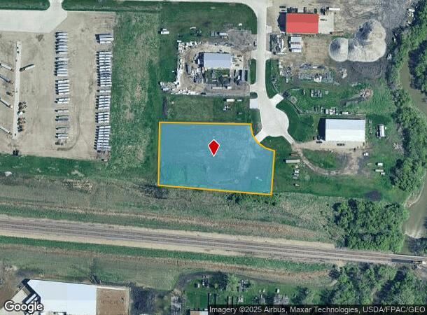
Property Record
614 5Th Street Ct Nw, West Fargo, ND 58078
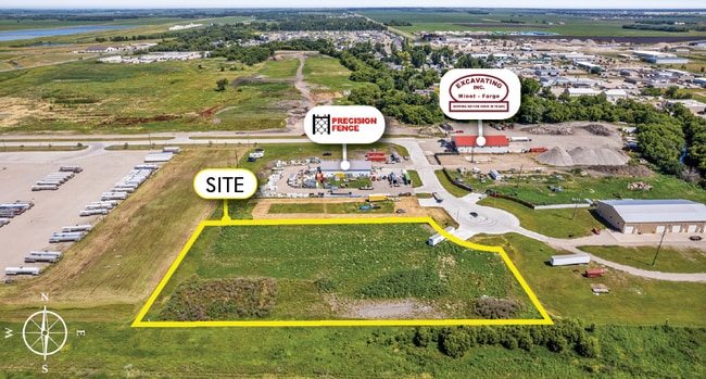
This Property Is For Sale
NEARBY LISTINGS FOR SALE OR LEASE
Property Detail
614 5Th Street Ct Nw
Fargo, ND-MN
The Yards Second Addition
02-3801-00080-000
LOT: 8 BLOCK: 1 ADDITION: THE YARDS 2ND ADDITION ADDITIONAL: THE YARDS 2ND LT 8 BLK 1
Commercialacreage
Cass
X
North Dakota
38017C0568G
8
2024
2.42 AC
2024
Fargo
040800
Other Market Areas
DEMOGRAPHICS near 614 5Th Street Ct Nw
1 Mile
3 Mile
5 Mile
2024 Total Population
3,894
32,569
93,066
2029 Population
4,160
34,635
99,485
Pop Growth 2024-2029
+ 6.83%
+ 6.34%
+ 6.90%
Average Age
39
38
35
2024 Total Households
1,648
14,200
39,791
HH Growth 2024-2029
+ 7.46%
+ 6.81%
+ 7.52%
Median Household Inc
$70,817
$67,416
$65,933
Avg Household Size
2.30
2.20
2.20
2024 Avg HH Vehicles
2.00
2.00
2.00
Median Home Value
$222,262
$236,059
$256,178
Median Year Built
1977
1993
2000
Nearby Places
- Restaurants
- Banks
- Shops
- Fitness
- Groceries
PUBLIC TRANSPORTATION
COMMUTER RAIL
DRIVE
WALK
Distance
17 min
7.8 mi
AIRPORT
Hector International
DRIVE
WALK
Distance
Hector International
20 min
9.2 mi
Nearby Properties
Address
Land Use
TOTAL SIZE
Lot Size
Zoning
Address
Land Use
TOTAL SIZE
Lot Size
Zoning
122,006 SF
24.45 AC
GI
Address
Land Use
TOTAL SIZE
Lot Size
Zoning
230,272 SF
21.77 AC
GC
Address
Land Use
TOTAL SIZE
Lot Size
Zoning
175,969 SF
35.10 AC
GI
Address
Land Use
TOTAL SIZE
Lot Size
Zoning
163,195 SF
11.95 AC
GC
Address
Land Use
TOTAL SIZE
Lot Size
Zoning
Address
Land Use
TOTAL SIZE
Lot Size
Zoning
37.39 AC
Address
Land Use
TOTAL SIZE
Lot Size
Zoning
152,509 SF
18.14 AC
Address
Land Use
TOTAL SIZE
Lot Size
Zoning
206,540 SF
16.68 AC
GI
Address
Land Use
TOTAL SIZE
Lot Size
Zoning
104,817 SF
13.93 AC
GC
Address
Land Use
TOTAL SIZE
Lot Size
Zoning
794,266 SF
36.84 AC
GC
Address
Land Use
TOTAL SIZE
Lot Size
Zoning
190,588 SF
6.32 AC
Address
Land Use
TOTAL SIZE
Lot Size
Zoning
75 AC
MHP
Address
Land Use
TOTAL SIZE
Lot Size
Zoning
218,579 SF
21.28 AC
GC
Address
Land Use
TOTAL SIZE
Lot Size
Zoning
49.50 AC
Address
Land Use
TOTAL SIZE
Lot Size
Zoning
152,508 SF
13.85 AC
GI
Address
Land Use
TOTAL SIZE
Lot Size
Zoning
155,989 SF
11.62 AC
GC
Address
Land Use
TOTAL SIZE
Lot Size
Zoning
15,895 SF
41.76 AC
Address
Land Use
TOTAL SIZE
Lot Size
Zoning
184,560 SF
17.11 AC
Address
Land Use
TOTAL SIZE
Lot Size
Zoning
135,235 SF
6.01 AC
GC
Address
Land Use
TOTAL SIZE
Lot Size
Zoning
99,300 SF
12.72 AC
Address
Land Use
TOTAL SIZE
Lot Size
Zoning
Address
Land Use
TOTAL SIZE
Lot Size
Zoning
207,189 SF
23.72 AC
Address
Land Use
TOTAL SIZE
Lot Size
Zoning
12.97 AC
GI
Address
Land Use
TOTAL SIZE
Lot Size
Zoning
Address
Land Use
TOTAL SIZE
Lot Size
Zoning
79,310 SF
17.79 AC
Address
Land Use
TOTAL SIZE
Lot Size
Zoning
354,677 SF
13.13 AC
Address
Land Use
TOTAL SIZE
Lot Size
Zoning
122,750 SF
14.27 AC
GI
Address
Land Use
TOTAL SIZE
Lot Size
Zoning
48,001 SF
4.35 AC
GC
Address
Land Use
TOTAL SIZE
Lot Size
Zoning
8,166 SF
8.26 AC
Address
Land Use
TOTAL SIZE
Lot Size
Zoning
101,324 SF
7.12 AC
LI
The World's #1 Commercial Real Estate Marketplace
Connect with us
© 2025 CoStar Group
The information above has been obtained from sources believed reliable. While we do not doubt its accuracy we have not verified it and make no guarantee, warranty or representation about it. It is your responsibility to independently confirm its accuracy and completeness. Any projections, opinions, assumptions, or estimates used are for example only and do not represent the current or future performance of the property. The value of this transaction to you depends on tax and other factors which should be evaluated by your tax, financial, and legal advisors. You and your advisors should conduct a careful, independent investigation of the property to determine to your satisfaction the suitability of the property for your needs.