Property Record
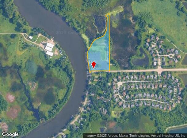
614 Rawson Bridge Rd, Port Barrington, IL 60010

This Property Is For Sale
NEARBY LISTINGS FOR SALE OR LEASE
Property Detail
614 Rawson Bridge Rd
15-32-100-017
DOC 2021R0068384 E SIDE FOX RIVER SE FR NW FRL1/4
Commercialnec
McHenry
AE
Illinois
17097C0205K
6.30 AC
2024
Far Northwest
2024
Chicago
870812
Chicago-Naperville-Elgin, IL-IN-WI
2,001 SF
DEMOGRAPHICS near 614 Rawson Bridge Rd
1 Mile
3 Mile
5 Mile
2024 Total Population
2,444
32,147
80,100
2029 Population
2,446
32,569
81,478
Pop Growth 2024-2029
+ 0.08%
+ 1.31%
+ 1.72%
Average Age
42
41
42
2024 Total Households
904
11,686
30,173
HH Growth 2024-2029
0.00%
+ 1.35%
+ 1.72%
Median Household Inc
$107,535
$111,198
$110,281
Avg Household Size
2.70
2.70
2.60
2024 Avg HH Vehicles
2.00
2.00
2.00
Median Home Value
$345,673
$328,792
$330,858
Median Year Built
1992
1984
1982
Nearby Places
- Restaurants
- Banks
- Shops
- Fitness
- Groceries
PUBLIC TRANSPORTATION
COMMUTER RAIL
Cary Station (Union Pacific Northwest Line - Northeast Illinois Regional Commuter Railroad (Metra))
DRIVE
WALK
Distance
Cary Station (Union Pacific Northwest Line - Northeast Illinois Regional Commuter Railroad (Metra))
11 min
4.4 mi
Fox River Grove Station (Union Pacific Northwest Line - Northeast Illinois Regional Commuter Railroad (Metra))
DRIVE
WALK
Distance
Fox River Grove Station (Union Pacific Northwest Line - Northeast Illinois Regional Commuter Railroad (Metra))
14 min
5.4 mi
AIRPORT
Chicago O'Hare International
DRIVE
WALK
Distance
Chicago O'Hare International
68 min
35.0 mi
Nearby Properties
Address
Land Use
TOTAL SIZE
Lot Size
Zoning
Address
Land Use
TOTAL SIZE
Lot Size
Zoning
393,554 SF
83.76 AC
Address
Land Use
TOTAL SIZE
Lot Size
Zoning
217,182 SF
22.43 AC
Address
Land Use
TOTAL SIZE
Lot Size
Zoning
212,880 SF
20.06 AC
Address
Land Use
TOTAL SIZE
Lot Size
Zoning
72,173 SF
5.23 AC
Address
Land Use
TOTAL SIZE
Lot Size
Zoning
114,186 SF
17.14 AC
Address
Land Use
TOTAL SIZE
Lot Size
Zoning
118,869 SF
5.88 AC
Address
Land Use
TOTAL SIZE
Lot Size
Zoning
34,600 SF
2.91 AC
Address
Land Use
TOTAL SIZE
Lot Size
Zoning
6.41 AC
Address
Land Use
TOTAL SIZE
Lot Size
Zoning
77,881 SF
4.60 AC
Address
Land Use
TOTAL SIZE
Lot Size
Zoning
28,340 SF
0.85 AC
Address
Land Use
TOTAL SIZE
Lot Size
Zoning
163,800 SF
5 AC
Address
Land Use
TOTAL SIZE
Lot Size
Zoning
13,833 SF
1.54 AC
Address
Land Use
TOTAL SIZE
Lot Size
Zoning
3.48 AC
Address
Land Use
TOTAL SIZE
Lot Size
Zoning
7,275 SF
7.88 AC
Address
Land Use
TOTAL SIZE
Lot Size
Zoning
22,770 SF
1.29 AC
Address
Land Use
TOTAL SIZE
Lot Size
Zoning
22,840 SF
0.60 AC
Address
Land Use
TOTAL SIZE
Lot Size
Zoning
25,900 SF
0.64 AC
Address
Land Use
TOTAL SIZE
Lot Size
Zoning
345,760 SF
11 AC
Address
Land Use
TOTAL SIZE
Lot Size
Zoning
4,608 SF
2.43 AC
Address
Land Use
TOTAL SIZE
Lot Size
Zoning
20,925 SF
1.04 AC
Address
Land Use
TOTAL SIZE
Lot Size
Zoning
17,600 SF
1.12 AC
Address
Land Use
TOTAL SIZE
Lot Size
Zoning
3,825 SF
2.99 AC
Address
Land Use
TOTAL SIZE
Lot Size
Zoning
150,600 SF
3 AC
Address
Land Use
TOTAL SIZE
Lot Size
Zoning
177,840 SF
2.53 AC
Address
Land Use
TOTAL SIZE
Lot Size
Zoning
40,192 SF
4.60 AC
Address
Land Use
TOTAL SIZE
Lot Size
Zoning
10,857 SF
1.68 AC
Address
Land Use
TOTAL SIZE
Lot Size
Zoning
21,730 SF
3.22 AC
Address
Land Use
TOTAL SIZE
Lot Size
Zoning
23,061 SF
1.43 AC
Address
Land Use
TOTAL SIZE
Lot Size
Zoning
14,736 SF
2.31 AC
Address
Land Use
TOTAL SIZE
Lot Size
Zoning
16,243 SF
1.92 AC
The World's #1 Commercial Real Estate Marketplace
Connect with us
© 2025 CoStar Group
The information above has been obtained from sources believed reliable. While we do not doubt its accuracy we have not verified it and make no guarantee, warranty or representation about it. It is your responsibility to independently confirm its accuracy and completeness. Any projections, opinions, assumptions, or estimates used are for example only and do not represent the current or future performance of the property. The value of this transaction to you depends on tax and other factors which should be evaluated by your tax, financial, and legal advisors. You and your advisors should conduct a careful, independent investigation of the property to determine to your satisfaction the suitability of the property for your needs.