Property Record
6143 Route 6N, West Springfield, PA 16443


NEARBY LISTINGS FOR SALE OR LEASE
-
-
View all West Springfield listings for lease on LoopNet.com
Property Detail
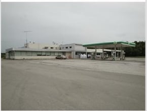
6143 Route 6N
39-024-048.0-001.00
6143 ROUTE 6N 11.48 AC CAL
Truckstopfuelanddiner
Erie
X
Pennsylvania
42049C0304D
11.43 AC
2025
Outlying Erie County
2025
Erie
010101
Erie, PA
13,430 SF
DEMOGRAPHICS near 6143 Route 6N
1 Mile
3 Mile
5 Mile
2024 Total Population
455
1,887
9,254
2029 Population
451
1,857
9,227
Pop Growth 2024-2029
(0.88%)
(1.59%)
(0.29%)
Average Age
43
43
42
2024 Total Households
182
759
3,073
HH Growth 2024-2029
(1.10%)
(1.84%)
(0.55%)
Median Household Inc
$61,346
$64,850
$54,963
Avg Household Size
2.40
2.40
2.30
2024 Avg HH Vehicles
2.00
2.00
2.00
Median Home Value
$153,086
$148,053
$114,753
Median Year Built
1960
1962
1950
Nearby Places
Map Layers
Map Styles
 Street
 Aerial
- Restaurants
- Banks
- Shops
- Fitness
- Groceries
PUBLIC TRANSPORTATION
AIRPORT
Erie International/Tom Ridge Field
DRIVE
WALK
Distance
Erie International/Tom Ridge Field
31 min
21.2 mi
Freight Ports
Port of Toledo
DRIVE
WALK
Distance
Port of Toledo
220 min
188.5 mi
SALE & LEASE HISTORY
LISTING DATE
SALE/LEASE

Oct 25, 2017
For Sale
May 12, 2025
For Lease
May 12, 2025
For Sale
Nearby Properties
Address
Land Use
TOTAL SIZE
Lot Size
Zoning
Address
Land Use
TOTAL SIZE
Lot Size
Zoning
10,524 SF
1 AC
R2
Address
Land Use
TOTAL SIZE
Lot Size
Zoning
353.60 AC
I2
Address
Land Use
TOTAL SIZE
Lot Size
Zoning
289.44 AC
I1
Address
Land Use
TOTAL SIZE
Lot Size
Zoning
3,605 SF
70.83 AC
R1
Address
Land Use
TOTAL SIZE
Lot Size
Zoning
713.04 AC
R1
Address
Land Use
TOTAL SIZE
Lot Size
Zoning
9,100 SF
1.08 AC
C1
Address
Land Use
TOTAL SIZE
Lot Size
Zoning
1,392 SF
2.84 AC
R2
Address
Land Use
TOTAL SIZE
Lot Size
Zoning
2,996 SF
82.31 AC
I1
Address
Land Use
TOTAL SIZE
Lot Size
Zoning
41.14 AC
R1
Address
Land Use
TOTAL SIZE
Lot Size
Zoning
175.88 AC
I1
Address
Land Use
TOTAL SIZE
Lot Size
Zoning
Address
Land Use
TOTAL SIZE
Lot Size
Zoning
1,968 SF
85.75 AC
Address
Land Use
TOTAL SIZE
Lot Size
Zoning
2,399 SF
84 AC
R1
Address
Land Use
TOTAL SIZE
Lot Size
Zoning
2,548 SF
24.20 AC
R1
Address
Land Use
TOTAL SIZE
Lot Size
Zoning
3,104 SF
32.46 AC
Address
Land Use
TOTAL SIZE
Lot Size
Zoning
1,864 SF
25 AC
R1
Address
Land Use
TOTAL SIZE
Lot Size
Zoning
7,200 SF
8.51 AC
C1
Address
Land Use
TOTAL SIZE
Lot Size
Zoning
4,997 SF
18.95 AC
R2
Address
Land Use
TOTAL SIZE
Lot Size
Zoning
10,400 SF
4.01 AC
R2
Address
Land Use
TOTAL SIZE
Lot Size
Zoning
2,565 SF
32.95 AC
R2
Address
Land Use
TOTAL SIZE
Lot Size
Zoning
2,800 SF
16.28 AC
R1
Address
Land Use
TOTAL SIZE
Lot Size
Zoning
3,200 SF
12.50 AC
C1
Address
Land Use
TOTAL SIZE
Lot Size
Zoning
1,910 SF
40.94 AC
R1
Address
Land Use
TOTAL SIZE
Lot Size
Zoning
5,208 SF
16 AC
R2
Address
Land Use
TOTAL SIZE
Lot Size
Zoning
25.98 AC
R1
Address
Land Use
TOTAL SIZE
Lot Size
Zoning
1,638 SF
14.06 AC
R1
Address
Land Use
TOTAL SIZE
Lot Size
Zoning
1,200 SF
71.58 AC
Address
Land Use
TOTAL SIZE
Lot Size
Zoning
2,142 SF
61.34 AC
Address
Land Use
TOTAL SIZE
Lot Size
Zoning
2,277 SF
19.63 AC
R2
Address
Land Use
TOTAL SIZE
Lot Size
Zoning
2,097 SF
17.57 AC
R1
The World's #1 Commercial Real Estate Marketplace
Connect with us
© 2026 CoStar Group
The information above has been obtained from sources believed reliable. While we do not doubt its accuracy we have not verified it and make no guarantee, warranty or representation about it. It is your responsibility to independently confirm its accuracy and completeness. Any projections, opinions, assumptions, or estimates used are for example only and do not represent the current or future performance of the property. The value of this transaction to you depends on tax and other factors which should be evaluated by your tax, financial, and legal advisors. You and your advisors should conduct a careful, independent investigation of the property to determine to your satisfaction the suitability of the property for your needs.