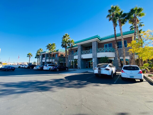
Property Record
6175 Spring Mountain Rd, Las Vegas, NV 89146
Current Lease Availabilities
NEARBY LISTINGS FOR SALE OR LEASE
Property Detail
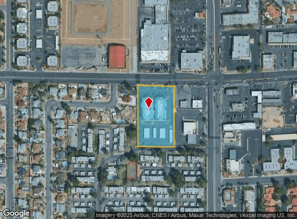
6175 Spring Mountain Rd
Las Vegas-Henderson-Paradise, NV
Parcel Map File 36 Page 33
163-14-601-006
PARCEL MAP FILE 36 PAGE 33 LOT 1 & LOT 2
Commercialnec
Clark
X
Nevada
32003C2551F
1
2025
2.12 AC
2025
Southwest Las Vegas
002936
Las Vegas
32,798 SF
DEMOGRAPHICS near 6175 Spring Mountain Rd
1 Mile
3 Mile
5 Mile
2024 Total Population
16,520
177,595
446,443
2029 Population
17,686
191,032
481,126
Pop Growth 2024-2029
+ 7.06%
+ 7.57%
+ 7.77%
Average Age
43
40
40
2024 Total Households
6,501
71,105
183,049
HH Growth 2024-2029
+ 7.01%
+ 7.56%
+ 7.82%
Median Household Inc
$58,505
$48,402
$51,649
Avg Household Size
2.50
2.40
2.40
2024 Avg HH Vehicles
2.00
2.00
2.00
Median Home Value
$333,363
$319,726
$339,960
Median Year Built
1981
1986
1990
Nearby Places
- Restaurants
- Banks
- Shops
- Fitness
- Groceries
PUBLIC TRANSPORTATION
AIRPORT
Harry Reid International
DRIVE
WALK
Distance
Harry Reid International
15 min
7.0 mi
Boulder City Municipal
DRIVE
WALK
Distance
Boulder City Municipal
42 min
27.9 mi
Nearby Properties
Address
Land Use
TOTAL SIZE
Lot Size
Zoning
Address
Land Use
TOTAL SIZE
Lot Size
Zoning
2,207,746 SF
74.17 AC
Address
Land Use
TOTAL SIZE
Lot Size
Zoning
1,494,289 SF
65.25 AC
H1
Address
Land Use
TOTAL SIZE
Lot Size
Zoning
248,689 SF
19.45 AC
H1
Address
Land Use
TOTAL SIZE
Lot Size
Zoning
777,838 SF
36.14 AC
H1
Address
Land Use
TOTAL SIZE
Lot Size
Zoning
754,711 SF
24.79 AC
H1
Address
Land Use
TOTAL SIZE
Lot Size
Zoning
1,345,377 SF
88.53 AC
H1
Address
Land Use
TOTAL SIZE
Lot Size
Zoning
987,719 SF
12.98 AC
H1
Address
Land Use
TOTAL SIZE
Lot Size
Zoning
740,584 SF
0.98 AC
Address
Land Use
TOTAL SIZE
Lot Size
Zoning
412,086 SF
33.58 AC
CP
Address
Land Use
TOTAL SIZE
Lot Size
Zoning
109,306 SF
25.79 AC
H1
Address
Land Use
TOTAL SIZE
Lot Size
Zoning
40 AC
PF
Address
Land Use
TOTAL SIZE
Lot Size
Zoning
Address
Land Use
TOTAL SIZE
Lot Size
Zoning
Address
Land Use
TOTAL SIZE
Lot Size
Zoning
6,310 SF
3.68 AC
Address
Land Use
TOTAL SIZE
Lot Size
Zoning
44,835 SF
2.58 AC
Address
Land Use
TOTAL SIZE
Lot Size
Zoning
22,018 SF
6.91 AC
Address
Land Use
TOTAL SIZE
Lot Size
Zoning
8,523 SF
6.06 AC
Address
Land Use
TOTAL SIZE
Lot Size
Zoning
12.23 AC
PF
Address
Land Use
TOTAL SIZE
Lot Size
Zoning
21,257 SF
12.72 AC
Address
Land Use
TOTAL SIZE
Lot Size
Zoning
28,956 SF
75.82 AC
CV
Address
Land Use
TOTAL SIZE
Lot Size
Zoning
4,872 SF
18.22 AC
R3
Address
Land Use
TOTAL SIZE
Lot Size
Zoning
294,204 SF
2.93 AC
M1
Address
Land Use
TOTAL SIZE
Lot Size
Zoning
7,289 SF
4.61 AC
C:R-3
Address
Land Use
TOTAL SIZE
Lot Size
Zoning
20,000 SF
37.09 AC
H1
Address
Land Use
TOTAL SIZE
Lot Size
Zoning
3.61 AC
PF
Address
Land Use
TOTAL SIZE
Lot Size
Zoning
271,484 SF
7.04 AC
C2
Address
Land Use
TOTAL SIZE
Lot Size
Zoning
322,005 SF
29.37 AC
C1
Address
Land Use
TOTAL SIZE
Lot Size
Zoning
6,558 SF
23.36 AC
R3
Address
Land Use
TOTAL SIZE
Lot Size
Zoning
66.57 AC
CV
Address
Land Use
TOTAL SIZE
Lot Size
Zoning
12,212 SF
8.29 AC
C1
The World's #1 Commercial Real Estate Marketplace
Connect with us
© 2025 CoStar Group
The information above has been obtained from sources believed reliable. While we do not doubt its accuracy we have not verified it and make no guarantee, warranty or representation about it. It is your responsibility to independently confirm its accuracy and completeness. Any projections, opinions, assumptions, or estimates used are for example only and do not represent the current or future performance of the property. The value of this transaction to you depends on tax and other factors which should be evaluated by your tax, financial, and legal advisors. You and your advisors should conduct a careful, independent investigation of the property to determine to your satisfaction the suitability of the property for your needs.