Property Record
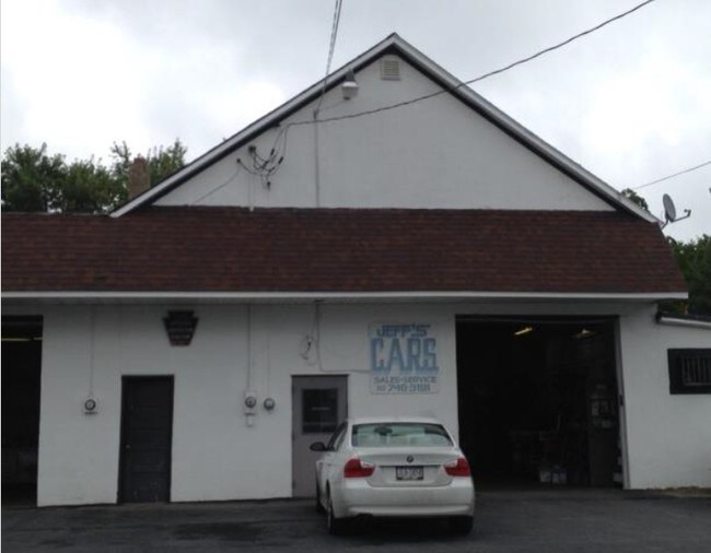
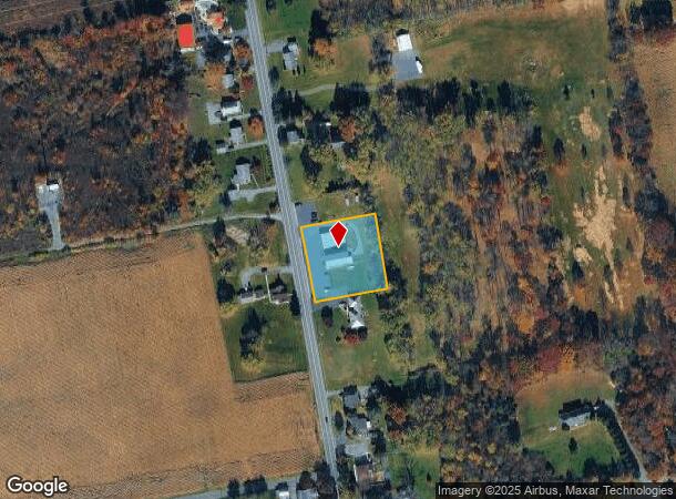
6146 Sullivan Trl, Nazareth, PA 18064

NEARBY LISTINGS FOR SALE OR LEASE
Property Detail
6146 Sullivan Trl
Autorepair
Northampton
X
Pennsylvania
42095C0145E
0.92 AC
2025
Lehigh Valley
2025
Philadelphia
015500
Allentown-Bethlehem-Easton, PA-NJ
5,544 SF
G8-10-14A-0626
DEMOGRAPHICS near 6146 Sullivan Trl
1 Mile
3 Mile
5 Mile
2024 Total Population
1,346
9,265
36,142
2029 Population
1,337
9,253
36,288
Pop Growth 2024-2029
(0.67%)
(0.13%)
+ 0.40%
Average Age
45
44
44
2024 Total Households
521
3,462
14,417
HH Growth 2024-2029
(0.77%)
(0.09%)
+ 0.44%
Median Household Inc
$85,344
$92,127
$81,396
Avg Household Size
2.50
2.60
2.50
2024 Avg HH Vehicles
2.00
2.00
2.00
Median Home Value
$298,935
$318,030
$287,470
Median Year Built
1974
1979
1971
Nearby Places
Map Layers
Map Styles
 Street
 Aerial
- Restaurants
- Banks
- Shops
- Fitness
- Groceries
PUBLIC TRANSPORTATION
AIRPORT
Lehigh Valley International
DRIVE
WALK
Distance
Lehigh Valley International
27 min
18.2 mi
Freight Ports
Port of Philadelphia
DRIVE
WALK
Distance
Port of Philadelphia
106 min
68.1 mi
SALE & LEASE HISTORY
LISTING DATE
SALE/LEASE

Sep 24, 2016
For Sale
Nearby Properties
Address
Land Use
TOTAL SIZE
Lot Size
Zoning
Address
Land Use
TOTAL SIZE
Lot Size
Zoning
430,352 SF
57.60 AC
GC/I
Address
Land Use
TOTAL SIZE
Lot Size
Zoning
352,026 SF
1.84 AC
GC/I
Address
Land Use
TOTAL SIZE
Lot Size
Zoning
349,517 SF
28.20 AC
HI
Address
Land Use
TOTAL SIZE
Lot Size
Zoning
324,240 SF
13.95 AC
HI
Address
Land Use
TOTAL SIZE
Lot Size
Zoning
214,540 SF
25.69 AC
GC/I
Address
Land Use
TOTAL SIZE
Lot Size
Zoning
193,460 SF
18.26 AC
IBP
Address
Land Use
TOTAL SIZE
Lot Size
Zoning
69,548 SF
9.18 AC
GC/I
Address
Land Use
TOTAL SIZE
Lot Size
Zoning
120,747 SF
22.45 AC
R12
Address
Land Use
TOTAL SIZE
Lot Size
Zoning
55,069 SF
6.77 AC
IC
Address
Land Use
TOTAL SIZE
Lot Size
Zoning
82,626 SF
18.96 AC
MDR
Address
Land Use
TOTAL SIZE
Lot Size
Zoning
29,666 SF
11.17 AC
FF
Address
Land Use
TOTAL SIZE
Lot Size
Zoning
37,164 SF
2.73 AC
HI
Address
Land Use
TOTAL SIZE
Lot Size
Zoning
118,536 SF
14.36 AC
GCI
Address
Land Use
TOTAL SIZE
Lot Size
Zoning
21,655 SF
4.49 AC
IP
Address
Land Use
TOTAL SIZE
Lot Size
Zoning
48,084 SF
7.96 AC
RA
Address
Land Use
TOTAL SIZE
Lot Size
Zoning
1,050 SF
4.48 AC
PR
Address
Land Use
TOTAL SIZE
Lot Size
Zoning
5,106 SF
60.79 AC
RA
Address
Land Use
TOTAL SIZE
Lot Size
Zoning
18,710 SF
26.90 AC
GC
Address
Land Use
TOTAL SIZE
Lot Size
Zoning
118,536 SF
8.17 AC
GCI
Address
Land Use
TOTAL SIZE
Lot Size
Zoning
53,467 SF
4.10 AC
IP
Address
Land Use
TOTAL SIZE
Lot Size
Zoning
24,194 SF
2.25 AC
GC/I
Address
Land Use
TOTAL SIZE
Lot Size
Zoning
298.49 AC
RC
Address
Land Use
TOTAL SIZE
Lot Size
Zoning
21,600 SF
11.74 AC
GC
Address
Land Use
TOTAL SIZE
Lot Size
Zoning
8,502 SF
6.34 AC
GC
Address
Land Use
TOTAL SIZE
Lot Size
Zoning
26,375 SF
4.97 AC
R12
Address
Land Use
TOTAL SIZE
Lot Size
Zoning
9,960 SF
30.20 AC
RC
Address
Land Use
TOTAL SIZE
Lot Size
Zoning
43,192 SF
2.82 AC
IP
Address
Land Use
TOTAL SIZE
Lot Size
Zoning
29,523 SF
4.68 AC
EE
Address
Land Use
TOTAL SIZE
Lot Size
Zoning
4,200 SF
6 AC
GC
Address
Land Use
TOTAL SIZE
Lot Size
Zoning
14,356 SF
7.89 AC
HDR
The World's #1 Commercial Real Estate Marketplace
Connect with us
© 2025 CoStar Group
The information above has been obtained from sources believed reliable. While we do not doubt its accuracy we have not verified it and make no guarantee, warranty or representation about it. It is your responsibility to independently confirm its accuracy and completeness. Any projections, opinions, assumptions, or estimates used are for example only and do not represent the current or future performance of the property. The value of this transaction to you depends on tax and other factors which should be evaluated by your tax, financial, and legal advisors. You and your advisors should conduct a careful, independent investigation of the property to determine to your satisfaction the suitability of the property for your needs.