Property Record
615 21St St, Heyburn, ID 83336
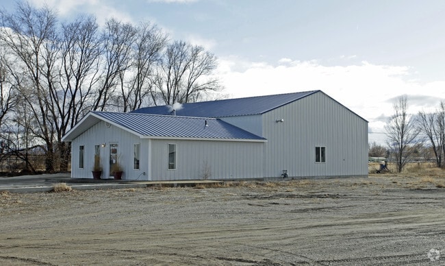

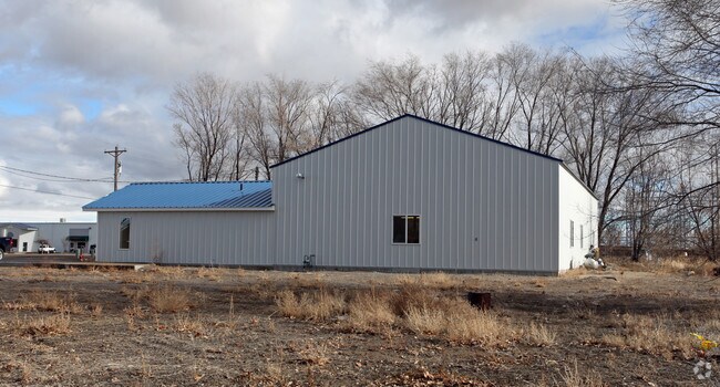
Property Detail
615 21St St
Burley, ID
LOT 1 ALFRESCO SUBDIVISION A PART OF BLK 179 HEYBURN TOWNSITE NW4NE4 15-10-23
RPH2030179001E
Cassia
Commercialnec
Idaho
2025
1
2025
0.31 AC
970200
Idaho South Area
3,800 SF
Other Market Areas
NEARBY LISTINGS FOR SALE OR LEASE
DEMOGRAPHICS near 615 21St St
1 mile
3 mile
5 mile
2025 Total Population
2,772
13,717
25,816
2030 Population
2,873
14,255
26,758
Pop Growth 2025-2030
+ 3.64%
+ 3.92%
+ 3.65%
Average Age
37
36
37
2025 Total Households
998
4,854
8,992
HH Growth 2025-2030
+ 3.61%
+ 3.96%
+ 3.67%
Median Household Inc
$77,646
$68,349
$70,862
Avg Household Size
2.80
2.80
2.80
2025 Avg HH Vehicles
2.00
2.00
2.00
Median Home Value
$423,387
$306,832
$313,174
Median Year Built
1986
1977
1976
Nearby Places
Map Layers
Map Styles
 Street
 Aerial
Transit
 Traffic
 Biking
Places
Listings with unknown addresses are not visible on the map
- Restaurants
- Banks
- Shops
- Fitness
- Groceries
Nearby Properties
Address
Land Use
TOTAL SIZE
Lot Size
Zoning
Address
Land Use
TOTAL SIZE
Lot Size
Zoning
Address
Land Use
TOTAL SIZE
Lot Size
Zoning
Address
Land Use
TOTAL SIZE
Lot Size
Zoning
163,069 SF
13.79 AC
Address
Land Use
TOTAL SIZE
Lot Size
Zoning
27.59 AC
Address
Land Use
TOTAL SIZE
Lot Size
Zoning
Address
Land Use
TOTAL SIZE
Lot Size
Zoning
81,334 SF
6.92 AC
Address
Land Use
TOTAL SIZE
Lot Size
Zoning
45,704 SF
1.72 AC
Address
Land Use
TOTAL SIZE
Lot Size
Zoning
3.19 AC
Address
Land Use
TOTAL SIZE
Lot Size
Zoning
45,672 SF
4.43 AC
4
Address
Land Use
TOTAL SIZE
Lot Size
Zoning
46.25 AC
Address
Land Use
TOTAL SIZE
Lot Size
Zoning
5.59 AC
Address
Land Use
TOTAL SIZE
Lot Size
Zoning
2.07 AC
Address
Land Use
TOTAL SIZE
Lot Size
Zoning
16.64 AC
Address
Land Use
TOTAL SIZE
Lot Size
Zoning
7.05 AC
Address
Land Use
TOTAL SIZE
Lot Size
Zoning
33,732 SF
3 AC
4
Address
Land Use
TOTAL SIZE
Lot Size
Zoning
0.57 AC
Address
Land Use
TOTAL SIZE
Lot Size
Zoning
10,088 SF
2.54 AC
Address
Land Use
TOTAL SIZE
Lot Size
Zoning
77,650 SF
8.28 AC
Address
Land Use
TOTAL SIZE
Lot Size
Zoning
8.68 AC
Address
Land Use
TOTAL SIZE
Lot Size
Zoning
24,600 SF
8.72 AC
Address
Land Use
TOTAL SIZE
Lot Size
Zoning
4.45 AC
Address
Land Use
TOTAL SIZE
Lot Size
Zoning
97,008 SF
6.66 AC
Address
Land Use
TOTAL SIZE
Lot Size
Zoning
1.81 AC
Address
Land Use
TOTAL SIZE
Lot Size
Zoning
20,150 SF
0.58 AC
Address
Land Use
TOTAL SIZE
Lot Size
Zoning
31,168 SF
3.95 AC
Address
Land Use
TOTAL SIZE
Lot Size
Zoning
3.49 AC
Address
Land Use
TOTAL SIZE
Lot Size
Zoning
13,586 SF
11.36 AC
Address
Land Use
TOTAL SIZE
Lot Size
Zoning
2.37 AC
Address
Land Use
TOTAL SIZE
Lot Size
Zoning
3.54 AC
The World's #1 Commercial Real Estate Marketplace
Connect with us
© 2026 CoStar Group
The information above has been obtained from sources believed reliable. While we do not doubt its accuracy we have not verified it and make no guarantee, warranty or representation about it. It is your responsibility to independently confirm its accuracy and completeness. Any projections, opinions, assumptions, or estimates used are for example only and do not represent the current or future performance of the property. The value of this transaction to you depends on tax and other factors which should be evaluated by your tax, financial, and legal advisors. You and your advisors should conduct a careful, independent investigation of the property to determine to your satisfaction the suitability of the property for your needs.