Property Record
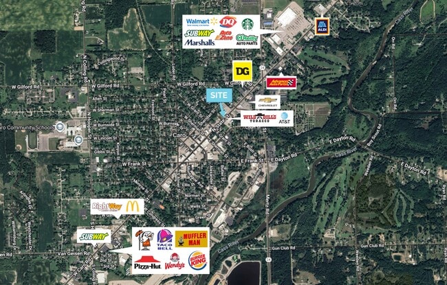
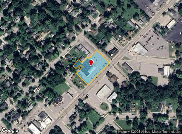
625 N State St, Caro, MI 48723
Current Lease Availabilities
NEARBY LISTINGS FOR SALE OR LEASE
Property Detail
625 N State St
050-003-200-1000-00
Nettletons Add
Commercialnec
"003-2010-000 SEC 03 T12N R9E SELY 41 FT OF LOT 6 & SELY 41 FT OF SWLY 1/2 OF LOT 5 BLK 1 NETTLETON'S ADD ALSO COM AT E 1/4 COR LOT 4 BLK 1 NETTLETON'S ADD, TH S 44 DEG 43' 05" E 24.75 FT, TH N 45 DEG E 106.8 FT, TH S 46 DEG 52' 30" E 165.09 FT, TH S
X
Tuscola
26157C0357E
Michigan
2024
2-6
2025
1.15 AC
000600
Midland/Flint
12,620 SF
Other Market Areas
DEMOGRAPHICS near 625 N State St
1 Mile
3 Mile
5 Mile
2024 Total Population
4,080
8,051
9,727
2029 Population
4,071
8,039
9,701
Pop Growth 2024-2029
(0.22%)
(0.15%)
(0.27%)
Average Age
42
43
43
2024 Total Households
1,678
3,346
4,018
HH Growth 2024-2029
(0.24%)
(0.15%)
(0.25%)
Median Household Inc
$52,331
$51,453
$53,046
Avg Household Size
2.30
2.20
2.30
2024 Avg HH Vehicles
1.00
2.00
2.00
Median Home Value
$86,401
$103,957
$111,349
Median Year Built
1957
1969
1970
Nearby Places
- Restaurants
- Banks
- Shops
- Fitness
- Groceries
PUBLIC TRANSPORTATION
AIRPORT
MBS International
DRIVE
WALK
Distance
MBS International
70 min
44.9 mi
Nearby Properties
Address
Land Use
TOTAL SIZE
Lot Size
Zoning
Address
Land Use
TOTAL SIZE
Lot Size
Zoning
74,535 SF
70.28 AC
Address
Land Use
TOTAL SIZE
Lot Size
Zoning
188,744 SF
20.76 AC
Address
Land Use
TOTAL SIZE
Lot Size
Zoning
28,644 SF
3.80 AC
Address
Land Use
TOTAL SIZE
Lot Size
Zoning
33.78 AC
Address
Land Use
TOTAL SIZE
Lot Size
Zoning
58,577 SF
85 AC
Address
Land Use
TOTAL SIZE
Lot Size
Zoning
56,224 SF
3.25 AC
Address
Land Use
TOTAL SIZE
Lot Size
Zoning
89,712 SF
10 AC
Address
Land Use
TOTAL SIZE
Lot Size
Zoning
38,927 SF
275.70 AC
Address
Land Use
TOTAL SIZE
Lot Size
Zoning
48,386 SF
9.89 AC
Address
Land Use
TOTAL SIZE
Lot Size
Zoning
67,018 SF
10.01 AC
Address
Land Use
TOTAL SIZE
Lot Size
Zoning
29,942 SF
2.72 AC
Address
Land Use
TOTAL SIZE
Lot Size
Zoning
61,280 SF
3.51 AC
Address
Land Use
TOTAL SIZE
Lot Size
Zoning
28,210 SF
3.38 AC
Address
Land Use
TOTAL SIZE
Lot Size
Zoning
34,230 SF
20.49 AC
Address
Land Use
TOTAL SIZE
Lot Size
Zoning
43,725 SF
6.31 AC
Address
Land Use
TOTAL SIZE
Lot Size
Zoning
39,755 SF
7.80 AC
Address
Land Use
TOTAL SIZE
Lot Size
Zoning
338.46 AC
Address
Land Use
TOTAL SIZE
Lot Size
Zoning
6,767 SF
3.50 AC
Address
Land Use
TOTAL SIZE
Lot Size
Zoning
76,638 SF
6.27 AC
Address
Land Use
TOTAL SIZE
Lot Size
Zoning
32,960 SF
4.31 AC
Address
Land Use
TOTAL SIZE
Lot Size
Zoning
20,118 SF
4.86 AC
Address
Land Use
TOTAL SIZE
Lot Size
Zoning
104.38 AC
Address
Land Use
TOTAL SIZE
Lot Size
Zoning
8.04 AC
Address
Land Use
TOTAL SIZE
Lot Size
Zoning
81,009 SF
0.05 AC
Address
Land Use
TOTAL SIZE
Lot Size
Zoning
2,196 SF
112.65 AC
Address
Land Use
TOTAL SIZE
Lot Size
Zoning
48,703 SF
2.28 AC
Address
Land Use
TOTAL SIZE
Lot Size
Zoning
54,876 SF
38.15 AC
Address
Land Use
TOTAL SIZE
Lot Size
Zoning
10,738 SF
0.30 AC
Address
Land Use
TOTAL SIZE
Lot Size
Zoning
14,577 SF
1.74 AC
Address
Land Use
TOTAL SIZE
Lot Size
Zoning
2,704 SF
80 AC
The World's #1 Commercial Real Estate Marketplace
Connect with us
© 2025 CoStar Group
The information above has been obtained from sources believed reliable. While we do not doubt its accuracy we have not verified it and make no guarantee, warranty or representation about it. It is your responsibility to independently confirm its accuracy and completeness. Any projections, opinions, assumptions, or estimates used are for example only and do not represent the current or future performance of the property. The value of this transaction to you depends on tax and other factors which should be evaluated by your tax, financial, and legal advisors. You and your advisors should conduct a careful, independent investigation of the property to determine to your satisfaction the suitability of the property for your needs.